
UNESCO World Heritage Sites in Turkmenistan
Turkmenistan has 3 sites on the UNESCO World Heritage List (3 cultural), the first inscribed in 1999 (Merv). The map below plots every one of them alongside the rest of the List, and each site is written up in full further down the page.
- World Heritage Sites
- 3
- Cultural
- 3
- Natural and Mixed
- 0
- First Inscribed
- 1999
Map of World Heritage Sites in Turkmenistan
CulturalNaturalMixedIn DangerLarge dots are in Turkmenistan. Click a dot to read about the site.

Merv
Turkmenistan · 37.6628° N, 62.1925° E · 4 km² · 32 km from Mary
Merv (Turkmen: Merw [ˈmeɾβ]; Persian: مرو [ˈmæɹv]), also called the Merve Oasis, was a major Iranian city in Central Asia, located on the historical Silk Road, near today's Mary, Turkmenistan. Human settlements on the site of Merv existed from the 3rd millennium BC until the 18th century AD. It changed hands repeatedly throughout history. Under the Achaemenid Empire, it was the center of the satrapy of Margiana. It was subsequently ruled by Hellenistic Kings, Parthians, Sasanians, Arabs (Rashidun, Umayyads and Abbasids), Ghaznavids, Seljuqs, Khwarazmians and Timurids, among others.
Merv served as the capital of several polities throughout its history. In the beginning of the 9th century, Merv was the seat of the Abbasid caliph al-Ma'mun and the capital of the entire Islamic caliphate. It served later as the seat of the Tahirid governors of Khorasan. In the 11th–12th centuries, Merv was the capital of the Great Seljuk Empire and remained so until its fall. Around this time, Merv turned into a chief centre of Islamic science and culture, attracting as well as producing renowned poets, musicians, physicians, mathematicians and astronomers.
Adapted from Wikipedia: Merv (CC BY-SA 4.0).
Why Merv Is Listed
- (ii)
- An important interchange of human values.
- (iii)
- A unique testimony to a cultural tradition or civilisation.
More about Merv
UNESCO's Description
Merv is the oldest and best-preserved of the oasis-cities along the Silk Route in Central Asia. The remains in this vast oasis span 4,000 years of human history. A number of monuments are still visible, particularly from the last two millennia.
From the UNESCO World Heritage Centre (CC BY-SA IGO 3.0).
Geography
The oasis of Merv is situated on the Murghab River that flows down from Afghanistan, on the southern edge of the Karakum Desert, at 37°30’N and 62°E, about 230 miles (370 km) north of Herat, and 280 miles (450 km) south of Khiva. Its area is about 1,900 square miles (4,900 km2). The great chain of mountains which, under the names of Paropamisade and Hindu Kush, extends from the Caspian Sea to the Pamir Mountains is interrupted some 180 miles (290 km) south of Merv. Through or near this gap flow northwards in parallel courses the Tejen and Murgab rivers, until they lose themselves in the Karakum Desert.
History
Merv has prehistoric roots: archaeological surveys have revealed many traces of village life as far back as the 3rd millennium BC and have associated the area culturally with the Bactria-Margiana Archaeological Complex. The geography of the Zend-Avesta (commentaries on the Avesta) mentions Merv (under the name of Mouru) along with Balkh. In Zoroastrianism, the god Ahura Mazda created Mouru as one of sixteen perfect lands.
Under the Achaemenid Empire (c. 550–330 BC), the historical record mentions Merv as a place of some importance: under the name of Margu, it occurs as part of one satrapy in the Behistun inscriptions (c. 515 BC) of the Persian monarch Darius the Great.
Economy
An elaborate system of canals cut from the Murghab irrigates the oasis. The country is renowned throughout the East for its fertility. Every kind of cereal and many fruits grow in great abundance, e.g. wheat, millet, barley and melons, also rice and cotton. Cotton seeds from archaeological levels as far back as the 5th century are the first indication that cotton textiles were already an important economic component of the Sassanian city. Silkworms have been bred. Turkmens possess a famous breed of horses (Turkoman horse) and keep camels, sheep, cattle, asses and mules. Turkmens work in silver and armour.
Sections adapted from Wikipedia: Merv (CC BY-SA 4.0).
Visiting Merv
Merv is an old city on the Silk Road 35 km east of the modern city of Mary in the Mary Province of Turkmenistan. There is a state park for the old city center, a UNESCO World Heritage Site.
The oasis of Merv is in the Karakum Desert at the crossing of the Amu Darya (or Oxus) River and the main route to Bukhara and Samarkand. It occupies an area of 86 x 75 km. Today the main city is Mary, which was mostly built during the Soviet period. However there are ruins of at least five older cities.
Travel notes adapted from Wikivoyage: Merv (CC BY-SA 4.0).
Köneürgenç
Turkmenistan · 42.3261° N, 59.1531° E · 4 km² · 2 km from Koneurgench
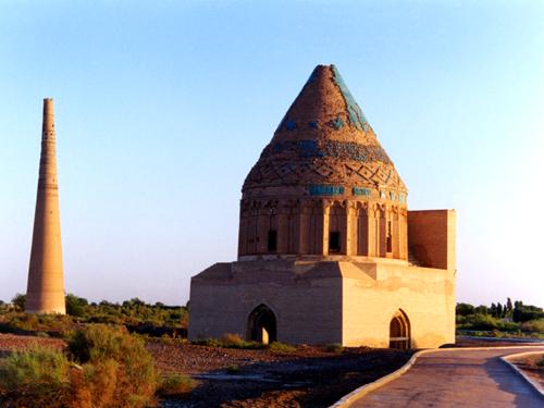
Konye-Urgench (Persian: کهنه گرگانج, romanized: Kuhna Gurgānj, lit. 'Old Gurgānj'), also known as Köneürgenç, Old Urgench or Urganj, is a city in north Turkmenistan, just south from its border with Uzbekistan. In 2022, it had a total population of 37,176 people.
It is the site of the ancient town of Gurgānj, which contains the ruins of the capital of Khwarazm. The inhabitants of the ancient city deserted it in the early eighteenth century in order to develop a new settlement, and Konye-Urgench has remained undisturbed ever since. In 2005, the ruins of Old Urgench were inscribed on the UNESCO List of World Heritage Sites.
Adapted from Wikipedia: Konye-Urgench (CC BY-SA 4.0).
Why Köneürgenç Is Listed
- (ii)
- An important interchange of human values.
- (iii)
- A unique testimony to a cultural tradition or civilisation.
More about Köneürgenç
UNESCO's Description
Kunya-Urgench is situated in north-western Turkmenistan, on the left bank of the Amu Daria River. Urgench was the capital of the Khorezm region, part of the Achaemenid Empire. The old town contains a series of monuments mainly from the 11th to 16th centuries, including a mosque, the gates of a caravanserai, fortresses, mausoleums and a 60-m high minaret. The monuments testify to outstanding achievements in architecture and craftsmanship whose influence reached Iran and Afghanistan, and later the architecture of the Mogul Empire of 16th-century India.
From the UNESCO World Heritage Centre (CC BY-SA IGO 3.0).
Geography
Konye-Urgench has a cold desert climate (BWk in the Köppen climate classification), with long and hot summers. Winters are relatively short, but quite cold. Precipitation is scarce throughout the year, with an average of 109 mm (4.36 in).
History and development
The exact dates when Konye-Urgench was founded remain uncertain, but archaeological finds at the Kyrkmolla Hill (one of the main fortresses at the site) reveal that the town already had a strong structure in the 5th and 4th centuries BC. Some of the earliest records show that Khwarezm was conquered by the Arabs in 712, who took the capital city of Kath of the Iranic Khwarazmian Afrighid dynasty. The city rose to prominence between the 10th and 14th centuries as the Khwarezmian capital, replacing Kath. Gurjanu served as an important trading center, competing in fame and population with many other Central Asian cities, such as Bukhara.
Overview
Located on the south side of the Amu Darya River, Old Urgench was situated on one of the most important medieval paths: the Silk Road, the crossroad of western and eastern civilisations. It is one of the most important archaeological sites in Turkmenistan, situated within a vast protected landscape zone and featuring a large number of well-preserved monuments dating from the 11th to the 16th centuries. They comprise mosques, the gates of a caravanserai, fortresses, mausoleums and a minaret, and the influence of their architectural style and craftsmanship reached Iran, Afghanistan and the later architecture of the Mughal Empire of 16th-century India.
Sections adapted from Wikipedia: Konye-Urgench (CC BY-SA 4.0).
Visiting Köneürgenç
Konye Urgench (Turkmen: Köneürgenç and also written Konye-Urgench, Old Urgench, or Urganj) is a city in Dashoguz Province, Turkmenistan. The former capital of the historically-important region of Khwarezmia, today Konye Urgench is an impressive collection of ruins that haven't been restored. Its proximity to the Turkmenistan-Uzbekistan border and to Khiva results in Konye Urgench being the first (or last) thing many travelers see when visiting Turkmenistan.
Travel notes adapted from Wikivoyage: Konye Urgench (CC BY-SA 4.0).

Nisa
Turkmenistan · 37.9511° N, 58.2124° E · 1 km² · 11 km from Buzmeyin
Nisa (Ancient Greek: Νῖσος, Νίσα, Νίσαιον; Turkmen: Nusaý; also Parthaunisa) was an ancient settlement of the Parthians, located near the Bagyr neighborhood of Ashgabat, Turkmenistan, 18 km west of the city center. Nisa is described by some as the first seat of the Arsacid Empire. It is traditionally assumed to have been founded by Arsaces I (reigned c. 250 BC–211 BC) and was reputedly the royal residence of the Parthian kings, although it has not been established that the fortress at Nisa was either a royal residence or a mausoleum.
In 2007, the fortress was declared a World Heritage Site by UNESCO.
Adapted from Wikipedia: Nisa, Turkmenistan (CC BY-SA 4.0).
Why Nisa Is Listed
- (ii)
- An important interchange of human values.
- (iii)
- A unique testimony to a cultural tradition or civilisation.
More about Nisa
UNESCO's Description
The Parthian Fortresses of Nisa consist of two tells of Old and New Nisa, indicating the site of one of the earliest and most important cities of the Parthian Empire, a major power from the mid 3rd century BC to the 3rd century AD. They conserve the unexcavated remains of an ancient civilization which skilfully combined its own traditional cultural elements with those of the Hellenistic and Roman west. Archaeological excavations in two parts of the site have revealed richly decorated architecture, illustrative of domestic, state and religious functions. Situated at the crossroads of important commercial and strategic axes, this powerful empire formed a barrier to Roman expansion while serving as an important communication and trading centre between east and west, north and south.
From the UNESCO World Heritage Centre (CC BY-SA IGO 3.0).
History
Nisa was a major trading hub in the Parthian Empire. It was later renamed Mithradātkert (Parthian: 𐭌𐭕𐭓𐭃𐭕𐭊𐭓𐭕, lit. 'fortress of Mithradates') by Mithridates I of Parthia (reigned c. 171 BC–138 BC). The region was famous for the beauty, agility and strength of its horses.
Sections adapted from Wikipedia: Nisa, Turkmenistan (CC BY-SA 4.0).
World Heritage in Turkmenistan: Quick Answers
- How many UNESCO World Heritage Sites are in Turkmenistan?
- Turkmenistan has 3 World Heritage Sites: 3 cultural.
- What was the first World Heritage Site in Turkmenistan?
- Merv, inscribed in 1999. The most recent is Nisa, inscribed in 2007.
- Are any World Heritage Sites in Turkmenistan in danger?
- None of the World Heritage Sites in Turkmenistan is on UNESCO's List of World Heritage in Danger.