
Map of El Salvador
El Salvador is a country in North America with its capital at San Salvador, home to about 6.37 million people across 21,041 km². The interactive map below plots 14 cities and towns, 1 rivers, 1 mountain summits and 3 ports recorded for El Salvador in YearMaps.
- Population
- 6.37 million
- Area
- 21,041 km²
- Capital
- San Salvador
- Continent
- North America
Interactive Map of El Salvador
Centred on San Salvador at 13.7119° N, 89.2050° W. Use the layer panel to switch on rivers, dams, ports, peaks and historical borders.
About El Salvador
El Salvador, officially the Republic of El Salvador, is a sovereign nation in Central America. Situated along the Pacific coast, it is bounded by Guatemala to the northwest and Honduras to the northeast. The country's political, economic, and cultural center is its capital and largest municipality, San Salvador. As of 2024, El Salvador's population was estimated at approximately 6 million inhabitants.
Historically, the territory comprising modern-day El Salvador was inhabited by various Mesoamerican civilizations, notably the Olmecs - whose presence around the first millennium BCE is attested by archeological monuments - followed by the Maya and later the Cuzcatlecs. In 1524, the region was conquered by the Spanish Empire and subsequently incorporated into the Viceroyalty of New Spain. Because the central administration in Mexico City exercised limited direct oversight over the Central American isthmus, Spain established the Captaincy General of Guatemala in 1609, an administrative division that included the territory of El Salvador throughout the colonial period.
Following its independence from Spain in 1821, El Salvador was briefly annexed by the First Mexican Empire before seceding to join the Federal Republic of Central America in 1823. Upon the dissolution of the federation in 1841, El Salvador established full sovereignty as an independent republic. Late in the 19th century, the nation temporarily reunited with Honduras and Nicaragua to form the Greater Republic of Central America, a political union that endured from 1896 to 1898. From the late 19th through the mid-20th century, El Salvador experienced prolonged political and economic instability, marked by frequent military coups, civil unrest, and a succession of authoritarian regimes. Entrenched socioeconomic disparities and escalating conflict eventually culminated in the Salvadoran Civil War (1979-1992), fought between the military-led government and the Farabundo Martí National Liberation Front (FMLN), a coalition of left-wing guerrilla groups. The war concluded with the signing of the Chapultepec Peace Accords in 1992. This negotiated settlement demilitarized the opposition, reformed the security forces, and established a multiparty constitutional republic. The conflict and its economic aftermath triggered mass emigration, primarily to the United States. Between 1980 and 2008, nearly one million citizens migrated to the U.S., establishing Salvadorans as the sixth-largest immigrant population in the nation by 2008.
Summary adapted from Wikipedia: El Salvador (CC BY-SA 4.0).

Geography and Climate of El Salvador
El Salvador achieved independence from Spain in 1821 and from the Central American Federation in 1839. A 12-year civil war, which cost about 75,000 lives, was brought to a close in 1992 when the government and leftist rebels signed a treaty that provided for military and political reforms. El Salvador is beset by one of the world's highest homicide rates and pervasive criminal gangs.
- Location
- Central America, bordering the North Pacific Ocean, between Guatemala and Honduras.
- Climate
- Tropical; rainy season (May to October); dry season (November to April); tropical on coast; temperate in uplands.
- Terrain
- Mostly mountains with narrow coastal belt and central plateau.
- Highest point
- Cerro El Pital 2,730 m.
- Lowest point
- Pacific Ocean 0 m.
- Coastline
- 307 km.
- Land borders
- Total: 590 km; border countries: Guatemala 199 km; Honduras 391 km.
- Natural resources
- Hydropower, geothermal power, petroleum, arable land.
- Land use
- Agricultural land: 57.7% (2023 est.); arable land: 34.8% (2023 est.); permanent crops: 7.7% (2023 est.); permanent pasture: 15.2% (2023 est.); forest: 33% (2023 est.); other: 9.3% (2023 est.)
- Natural hazards
- Known as the Land of Volcanoes; frequent and sometimes destructive earthquakes and volcanic activity; extremely susceptible to hurricanes volcanism: significant volcanic activity; San Salvador (1,893 m), which last erupted in 1917, has the potential to cause major harm to the country's capital, which lies just below the volcano's slopes; San Miguel (2,130 m) is one of the most active volcanoes in the country; other historically active volcanoes include Conchaguita, Ilopango, Izalco, and Santa Ana.
- Geographic note
- Smallest Central American country and only one without a coastline on the Caribbean Sea.
- Languages
- Spanish (official), Nawat (among some indigenous)
- Religions
- Roman Catholic 43.9%, Protestant 39.6% (Evangelical - unspecified 38.2%, Evangelical - Methodist 1.3%, Evangelical - Baptist 0.1%), none 16.3%, unspecified 0.2% (2023 est.)
- Ethnic groups
- Mestizo 86.3%, White 12.7%, Indigenous 0.2% (includes Lenca, Kakawira, Nahua-Pipil), Black 0.1%, other 0.6% (2007 est.)
- Economy
- Upper-middle-income, dollarized Central American economy; reliant on remittances from US; recent growth linked to infrastructure investment, consumption, and crime reduction; $1.3 billion IMF loan to address fiscal imbalances; Bitcoin adopted as legal tender; persistent poverty and large informal sector.
From the CIA World Factbook (public domain), archived edition of 2026-01-22. The Factbook is no longer updated, so figures reflect that edition.
El Salvador in Numbers
- Population
- 6.37 million
- GDP
- US$36.7 billion
- GDP per person
- US$5,767
- Life expectancy
- 72.3 years
- Population growth
- 0.43% a year
- Population density
- 306 per km²
- Urban population
- 75.5%
- Surface area
- 21,040 km²
- Forest cover
- 33.0%
- Arable land
- 34.8%
- Access to electricity
- 98.7%
- Internet users
- 66.5%
Indicators from World Bank Open Data (CC BY 4.0). The year under each figure is its reference year.
El Salvador in Depth
History
During the Pleistocene epoch, the region was inhabited by extinct megafauna, including the giant ground sloth Eremotherium, the toxodontid Mixotoxodon, the gomphothere Cuvieronius, the glyptodont Glyptotherium, the camelid Hemiauchenia, and the prehistoric horse Equus conversidens. Archeological evidence, particularly fluted stone projectile points discovered in western El Salvador, incidicates that human settlement likely dates back to the Paleoindian period.
Archaeological research into pre-Columbian El Salvador remains limited, largely due to high population density restricting excavation opportunities and historical volcanic activity blanketing potential sites under thick layers of ash.
Geography
El Salvador lies in the isthmus of Central America between latitudes 13° and 15°N, and longitudes 87° and 91°W. It stretches 270 km (168 mi) from west-northwest to east-southeast and 142 km (88 mi) north to south, with a total area of 21,041 km2 (8,124 sq mi). As the smallest and most densely populated country in continental America, El Salvador is affectionately called Pulgarcito de America (the "Tom Thumb of the Americas"). El Salvador shares borders with Guatemala and Honduras, as well as a coastline with the Pacific Ocean. The total national boundary length is 546 km (339 mi): 203 km (126 mi) with Guatemala and 343 km (213 mi) with Honduras. It is the only Central American country that has no Caribbean coastline. The coastline on the Pacific is 307 km (191 mi) long.
Economy
El Salvador's economy has been hampered at times by natural disasters such as earthquakes and hurricanes, by government policies that mandate large economic subsidies, and by official corruption. Subsidies became such a problem that in April 2012, the International Monetary Fund suspended a $750 million loan to the central government. President Funes' chief of cabinet, Alex Segovia, acknowledged that the economy was at the "point of collapse".
Gross domestic product (GDP) in purchasing power parity estimate for 2021 is US$57.95 billion growing real GDP at 4.2% for 2021. The service sector is the largest component of GDP at 64.1%, followed by the industrial sector at 24.7% (2008 est.) and agriculture represents 11.2% of GDP (2010 est.).
Demographics
El Salvador's population was 6,314,167 in 2021, compared to 2,200,000 in 1950. In 2010 the percentage of the population below the age of 15 was 32.1%, 61% were between 15 and 65 years of age, while 6.9% were 65 years or older. The capital city of San Salvador has a population of about 2.1 million people. An estimated 42% of El Salvador's population live in rural areas. Urbanization has expanded at a phenomenal rate in El Salvador since the 1960s, with millions moving to the cities and creating associated problems for urban planning and services.
Sections adapted from Wikipedia: El Salvador (CC BY-SA 4.0).
El Salvador: Key Facts
| Currencies | United States dollar, Bitcoin |
|---|---|
| Official language | Spanish |
| Head of state | Nayib Bukele |
| Head of government | Nayib Bukele |
| Form of government | republic, representative democracy |
| Calling code | +503 |
| Internet domain | .sv |
| Highest point | Cerro El Pital |
| Lowest point | Pacific Ocean |
| Established | 2 February 1841 |
Facts from Wikidata Q792 (CC0).
History of El Salvador: Empires and States
The atlas records 4 polities whose mapped territory included part of El Salvador, from Mayan City-States in 247 BCE to 2024 CE. They are listed in the order they first appear.
| Polity | Period here | Extent |
|---|---|---|
| Mayan City-States | 247 BCE – 849 CE | A small part |
| The Spanish Empire | 1526–1821 CE | Nearly all |
| United Provinces of Central America | 1824–1839 CE | Nearly all |
| Republic of El Salvador | 1840–2024 CE | Nearly all |
Historical Maps of El Salvador
El Salvador on the world map in each year one of these states held it:
Derived by testing mapped cities against dated territorial polygons. Dates are when the polygons cover this place, not the polity's whole lifespan, and polities absent from the source dataset are not listed.
Visiting El Salvador
El Salvador has many natural riches, such as beautiful and secluded beaches on the Pacific coast of Central America, majestic forests in the mountains and striking volcanoes. The countryside of El Salvador is breathtaking, with volcanoes and mountains offering "green" adventurers exactly what they are looking for. Many environmentally-oriented community-based organizations promote eco-tourism.
Travel notes adapted from Wikivoyage: El Salvador (CC BY-SA 4.0).
Largest Cities in El Salvador
14 cities recorded. Ranked by metropolitan population. A port city's harbour is written up on the page of its sea.
| # | Name | Population | Region | Role |
|---|---|---|---|---|
| 1 | San Salvador | 1.43 million | San Salvador | National capital |
| 2 | Santa Ana | 234,478 | Santa Ana | Admin-1 capital |
| 3 | San Miguel | 201,563 | San Miguel | Admin-1 capital |
| 4 | Sonsonate | 168,947 | Sonsonate | Admin-1 capital |
| 5 | Nueva San Salvador | 124,694 | La Libertad | Admin-1 capital |
| 6 | Usulután | 51,910 | Usulután | Admin-1 capital |
| 7 | Cojutepeque | 48,411 | Cuscatlán | Admin-1 capital |
| 8 | Zacatecoluca | 39,613 | La Paz | Admin-1 capital |
| 9 | San Vicente | 37,326 | San Vicente | Admin-1 capital |
| 10 | Ahuachapán | 34,102 | Ahuachapán | Admin-1 capital |
| 11 | Chalatenango | 29,271 | Chalatenango | Admin-1 capital |
| 12 | Sensuntepeque | 26,989 | Cabañas | Admin-1 capital |
| 13 | La Unión | 26,807 | La Unión | Admin-1 capital |
| 14 | San Francisco Gotera | 16,152 | Morazán | Admin-1 capital |
Highest Mountains in El Salvador
1 mountain recorded. Ranked by summit elevation above sea level. A summit on a border is listed under both countries.
| # | Name | Elevation | Feet | Region |
|---|---|---|---|---|
| 1 | Cerro El Pital | 2,730 m | 8,957 ft | North America |
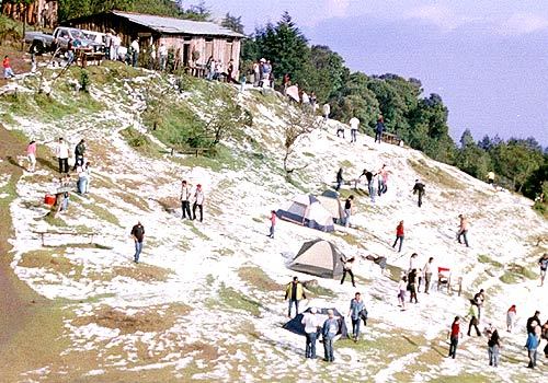
Cerro El Pital
Mountain · 2,730 m
Cerro El Pital is a mountain rising to 2,730 metres (8,957 ft) in El Salvador and Honduras, in the North America region. The summit stands on the border between them. From PeakBagger.com, with kind permission..
Cerro El Pital is a mountain in El Salvador, Central America and near the border with Honduras. It is located 12 km (7 mi) from the town of La Palma at a height of 2,730 m (8,957 ft) above sea level, and is the highest point in Salvadoran territory. Cerro El Pital is in the middle of a cloud forest that has an average annual temperature of 10 °C (50 °F).
It is one of the most popular tourist draws in El Salvador, with great biodiversity in a wide altitudinal range containing many endangered species of flora and fauna. The cloud forest has some of the rarest plants and animals in the country, including quetzals and other endangered species.
From November to February the temperature ranges between −6 °C (21 °F) and 10 °C (50 °F) (lowest recorded, in January 1956) and in the rest of the year the temperature ranges between 5 °C (41 °F) and 17 °C (63 °F). It is the coldest place in El Salvador. On 13 April 2004, much of the mountain was blanketed by an accumulation of hail during a storm, an unusual event that caused a commotion among the local community.
Adapted from Wikipedia: Cerro El Pital (CC BY-SA 4.0).
- Elevation
- 2,730 m (8,957 ft)
- Global rank
- #290 of 641 indexed
- Region
- North America (#64)
- Subregion
- Central America
- Countries
- El Salvador, Honduras
- Coordinates
- 14.3801°, -89.1200°
Of the 641 named summits indexed in YearMaps, Cerro El Pital ranks #290 by elevation, below Paektu-san (2,744 m) and above Jabal Hamoyet (2,726 m).
- Ranges:
- Sierra Madre Oriental (North America), Ouachita Mountains (North America)
- Settlements below:
- Chalatenango (34 km), Santa Ana (64 km), San Salvador (75 km)
More about Cerro El Pital
Cerro El Pital: Key Facts
| Topographic prominence | 1,530 m |
|---|---|
| Mountain range | Sierra Madre de Chiapas |
Facts from Wikidata Q74214 (CC0).
Rivers in El Salvador
1 river recorded. Listed alphabetically. A river is listed where its mapped reach lies, so long rivers appear under more than one country.
| Name | Type | Also Flows Through |
|---|---|---|
| Lempa | River | Honduras |
Ports in El Salvador
3 ports recorded. Ranked by approach channel depth, the figure that limits which ships can call. Harbours link to their write-up on the page of the sea or coast they lie on.
| # | Name | Channel Depth | Class | Sea | Max Vessel |
|---|---|---|---|---|---|
| 1 | la Union | 49.4 m | Very Small | Pacific Coast of North & Central America | large vessels |
| 2 | Acajutla | — | Very Small | Pacific Coast of North & Central America | large vessels |
| 3 | Acajutla Offshore Terminal | — | Very Small | Pacific Coast of North & Central America | large vessels |
UNESCO World Heritage Sites in El Salvador
1 World Heritage Site recorded. Listed by year of inscription, earliest first. Sites shared with another country appear under each.
| # | Name | Inscribed | Type | Criteria |
|---|---|---|---|---|
| 1 | Joya de Cerén | 1993 | Cultural | (iii) (iv) |
Mountain Ranges, Deserts and Landforms of El Salvador
1 landform recorded. Ranked by mapped area. Covers mountain ranges, deserts, plateaus, named glaciers, plains, basins, peninsulas and capes. One that crosses a border is listed under every country it lies in, with the area of the whole feature.
| # | Name | Area | Type | Region |
|---|---|---|---|---|
| 1 | Central America | 787,235 km² | Isthmus | North America |

Central America
Isthmus · 787,235 km²
Central America is an isthmus in North America (Central America), covering an estimated 787,235 km². It extends across Mexico, Nicaragua, Honduras, Guatemala, Panama, Costa Rica, El Salvador and Belize. It is the 20th-largest of the 231 landforms with a mapped extent in YearMaps.
Central America is a subregion of North America. Its political boundaries are defined as bordering Mexico to the north, Colombia to the southeast, the Caribbean to the east, and the Pacific Ocean to the southwest. Central America is usually defined as consisting of seven countries: Belize, Costa Rica, El Salvador, Guatemala, Honduras, Nicaragua, and Panama, and also, in specialized contexts, including Mexico. Within Central America is the Mesoamerican biodiversity hotspot, which extends from southern Mexico to southeastern Panama. Due to the presence of several active geologic faults and the Central America Volcanic Arc, seismic activity in the region, such as volcanic eruptions and earthquakes, is high, which has caused death, injury, and property damage.
Central America includes portions of two recognized cultural areas: the Isthmo-Colombian cultural area, which encompasses modern Panama, Costa Rica, and the eastern portions of Nicaragua and Honduras, along with regions to the east; and the Mesoamerican cultural area, encompassing Guatemala, Belize, El Salvador, and the western portions of Honduras and Nicaragua, along with the southern part of Mexico.
Adapted from Wikipedia: Central America (CC BY-SA 4.0).
- Feature class
- Isthmus
- Mapped extent
- 787,235 km²
- Size rank
- #20 of 231 landforms
- Region
- North America
- Subregion
- Central America
- Countries
- Mexico, Nicaragua, Honduras, Guatemala, Panama, Costa Rica, El Salvador, Belize
- Coordinates
- 13.8877°, -85.5972°
- Summits:
- Cerro El Pital (2,730 m)
- Ranges:
- Sierra Madre Oriental (North America), Ouachita Mountains (North America)
- Settlements:
- San Vicente (7 km), Cojutepeque (20 km), Sensuntepeque (24 km)
More about Central America
Geography
Central America is a part of North America consisting of a tapering isthmus running from the southern extent of Mexico to the northwestern portion of South America. Central America has the Gulf of Mexico, a body of water within the Atlantic Ocean, to the north; the Caribbean Sea, also part of the Atlantic Ocean, to the northeast; and the Pacific Ocean to the southwest. Some physiographists define the Isthmus of Tehuantepec as the northern geographic border of Central America, while others use the northwestern borders of Belize and Guatemala. From there, the Central American land mass extends southeastward to the Atrato River, where it connects to the Pacific Lowlands in northwestern South America.
History
Central America was formed more than 3 million years ago, as part of the Isthmus of Panama, when its portion of land connected each side of water.
In the Pre-Columbian era, the northern areas of Central America were inhabited by the indigenous peoples of Mesoamerica. Most notable among these were the Mayans, who had built numerous cities throughout the region, and the Aztecs, who had created a vast empire. The pre-Columbian cultures of eastern Honduras, Caribbean Nicaragua, most of Costa Rica and Panama were predominantly speakers of the Chibchan languages at the time of European contact and are considered by some culturally different and grouped in the Isthmo-Colombian Area.
Economy
Signed in 2004, the Central American Free Trade Agreement (CAFTA) is an agreement between the United States, Costa Rica, El Salvador, Guatemala, Honduras, Nicaragua, and the Dominican Republic. The treaty is aimed at promoting free trade among its members.
Guatemala has the largest economy in the region. Its main exports are coffee, sugar, bananas, petroleum, clothing, and cardamom. Of its 10.29 billion dollar annual exports, 40.2% go to the United States, 11.1% to neighboring El Salvador, 8% to Honduras, 5.5% to Mexico, 4.7% to Nicaragua, and 4.3% to Costa Rica.
The region is particularly attractive for companies (especially clothing companies) because of its geographical proximity to the United States, very low wages and considerable tax advantages.
Sections adapted from Wikipedia: Central America (CC BY-SA 4.0).
Central America: Key Facts
| Area | 560,988 km² |
|---|---|
| Highest point | Volcán Tajumulco |
Facts from Wikidata Q27611 (CC0).
Countries Bordering El Salvador
Land and maritime neighbours.
More Maps in North America
El Salvador: Quick Answers
- What is the capital of El Salvador?
- The capital of El Salvador is San Salvador.
- What is the population of El Salvador?
- El Salvador has a population of about 6.37 million, the #113 largest of 225 countries in YearMaps. Source: World Bank, 2025.
- How big is El Salvador?
- El Salvador covers 21,041 km², ranking #154 by area, with about 303 people per square kilometre.
- Which continent is El Salvador in?
- El Salvador is in North America.
- Which countries border El Salvador?
- El Salvador shares a land or maritime border with Guatemala, Honduras.
- What is the largest city in El Salvador?
- San Salvador is the largest city in El Salvador, with a metropolitan population of about 1.43 million.
- What is the highest mountain in El Salvador?
- The highest summit recorded for El Salvador in YearMaps is Cerro El Pital at 2,730 m (8,957 ft). Summits on a border are counted for both countries.