
Map of Honduras
Honduras is a country in North America with its capital at Tegucigalpa, home to about 11.01 million people across 112,492 km². The interactive map below plots 19 cities and towns, 3 rivers, 3 mountain summits and 8 ports recorded for Honduras in YearMaps.
- Population
- 11.01 million
- Area
- 112,492 km²
- Capital
- Tegucigalpa
- Continent
- North America
Interactive Map of Honduras
Centred on Tegucigalpa at 14.1040° N, 87.2195° W. Use the layer panel to switch on rivers, dams, ports, peaks and historical borders.
About Honduras
Honduras, officially the Republic of Honduras, is a country in Central America. It is bordered to the west by Guatemala, to the southwest by El Salvador, to the southeast by Nicaragua, to the south by the Pacific Ocean at the Gulf of Fonseca, and to the north by the Gulf of Honduras, a large inlet of the Caribbean Sea. Its capital and largest city is Tegucigalpa.
Honduras was home to several important Mesoamerican cultures, most notably the Maya, before Spanish colonization in the 16th century. The Spanish introduced Catholicism and the Spanish language, along with numerous customs that have blended with the indigenous culture. Honduras became independent in 1821 and has since been a republic, although it has consistently endured much social strife and political instability, and remains one of the poorest countries in the Western Hemisphere. In 1960, the northern part of what was the Mosquito Coast was transferred from Nicaragua to Honduras by the International Court of Justice.
The economy is primarily agricultural, making it vulnerable to natural disasters such as Hurricane Mitch in 1998. Honduras has a Human Development Index of 0.624, ranking 138th in the world. In 2022, according to the National Institute of Statistics of Honduras, 73% of the country's population lived in poverty, and 53% lived in extreme poverty. The lower class is primarily agriculturally based while wealth is concentrated in the urban centers. The country is one of the most economically unequal in Latin America. Honduran society is predominantly Mestizo; however, there are also significant Indigenous, Black, and White communities.
In the early 20th century, Honduras was dominated by transnational agricultural companies, whose interests were protected militarily by the United States. The term "banana republic" was originally coined to describe Honduras's politically unstable, corporate-dominated democracy. The civilian government was overthrown in a 1963 military coup, and the nation returned to civilian rule in 1979. The United States re-established its military presence in Honduras in the 1980s, using Honduras as a base of operations to oppose the Nicaraguan government in the Contra war.
A 2009 military coup toppled the government of Manuel Zelaya, and controversy arose from claims of electoral fraud in the subsequent 2013 and 2017 presidential elections. In 2021 Xiomara Castro was elected to the presidency, returning the left to power for the first time since the 2009 coup. Nasry Asfura won the 2025 election amid claims of fraud and electoral interference by the United States.
Summary adapted from Wikipedia: Honduras (CC BY-SA 4.0).

Geography and Climate of Honduras
Once part of Spain's vast empire in the New World, Honduras became an independent nation in 1821. After two and a half decades of mostly military rule, a freely elected civilian government came to power in 1982. During the 1980s, Honduras proved a haven for anti-Sandinista contras fighting the Marxist Nicaraguan Government and an ally to Salvadoran Government forces fighting leftist guerrillas. Hurricane Mitch devastated the country in 1998, killing about 5,600 people and causing approximately $2 billion in damage. Since then, the economy has slowly rebounded, despite COVID-19 and severe storm-related setbacks in 2020 and 2021.
- Location
- Central America, bordering the Caribbean Sea, between Guatemala and Nicaragua and bordering the Gulf of Fonseca (North Pacific Ocean), between El Salvador and Nicaragua.
- Climate
- Subtropical in lowlands, temperate in mountains.
- Terrain
- Mostly mountains in interior, narrow coastal plains.
- Highest point
- Cerro Las Minas 2,870 m.
- Lowest point
- Caribbean Sea 0 m.
- Coastline
- 823 km (Caribbean Sea 669 km; Gulf of Fonseca 163 km)
- Land borders
- Total: 1,575 km; border countries: Guatemala 244 km; El Salvador 391 km; Nicaragua 940 km.
- Major lakes
- Salt water lake(s): Laguna de Caratasca - 1,110 sq km.
- Natural resources
- Timber, gold, silver, copper, lead, zinc, iron ore, antimony, coal, fish, hydropower.
- Land use
- Agricultural land: 32% (2023 est.); arable land: 9.1% (2023 est.); permanent crops: 5.4% (2023 est.); permanent pasture: 17.5% (2023 est.); forest: 53.3% (2023 est.); other: 14.8% (2023 est.)
- Natural hazards
- Frequent, but generally mild, earthquakes; extremely susceptible to damaging hurricanes and floods along the Caribbean coast.
- Geographic note
- Has only a short Pacific coast but a long Caribbean shoreline, including the virtually uninhabited eastern Mosquito Coast.
- Languages
- Spanish (official), Amerindian dialects.
- Religions
- Evangelical 55%, Roman Catholic 33.4%, none 10.1%, unspecified 1.5% (2023 est.)
- Ethnic groups
- Mestizo (mixed Indigenous and European) 90%, Indigenous 7%, African descent 2%, White 1%.
- Economy
- Second-fastest-growing Central American economy; COVID-19 and two hurricanes crippled activity; high poverty and inequality; declining-but-still-high violent crime disruption; systemic corruption; coffee and banana exporter; enormous remittances.
From the CIA World Factbook (public domain), archived edition of 2026-01-22. The Factbook is no longer updated, so figures reflect that edition.
Honduras in Numbers
- Population
- 11.01 million
- GDP
- US$39.6 billion
- GDP per person
- US$3,598
- Life expectancy
- 73.0 years
- Population growth
- 1.65% a year
- Population density
- 97 per km²
- Urban population
- 59.3%
- Surface area
- 112,492 km²
- Forest cover
- 52.8%
- Arable land
- 9.1%
- Access to electricity
- 95.5%
- Internet users
- 58.6%
Indicators from World Bank Open Data (CC BY 4.0). The year under each figure is its reference year.
Honduras in Depth
History
In the pre-Columbian era, the territory was split between two large and diverse cultural regions: Mesoamerica in the west and the Isthmo-Colombian area in the east. Each complex had a "core area" within Honduras (the far west for Mesoamerica, and La Mosquitia for the Isthmo-Colombian area). The intervening area was one of gradual transition, with influences ebbing and flowing over time. For instance, Mesoamerican influences expanded at the time of the preclassic Olmec culture, and later again at the time of the postclassic Toltec culture. On the other hand, Isthmo-Colombian influences intensifed during the classic period.
In the extreme west, Maya civilization flourished for hundreds of years.
Geography
The north coast of Honduras borders the Caribbean Sea, and the Pacific Ocean lies south through the Gulf of Fonseca. Honduras consists mainly of mountains, with narrow plains along the coasts. A large undeveloped lowland jungle, La Mosquitia, lies in the northeast and the heavily populated lowland Sula valley in the northwest.
The Islas de la Bahía and the Swan Islands are off the north coast. Misteriosa Bank and Rosario Bank, 130 to 150 kilometres (81 to 93 miles) north of the Swan Islands, fall within the exclusive economic zone of Honduras. Natural resources include timber, gold, silver, copper, lead, zinc, iron ore, antimony, coal, fish, shrimp, and hydropower.
The climate varies from tropical in the lowlands to temperate in the mountains.
Economy
The World Bank categorizes Honduras as a low middle-income nation. The per capita income is around US$4,000, making it one of the lowest in North America and Central America. In 2016, more than 66% of the population was living below the poverty line.
Economic growth has averaged 7% per year, one of the highest rates in Latin America as of 2010. Despite this, Honduras has seen the least development amongst all Central American countries. Honduras is ranked 130 of 188 countries with a Human Development Index of.625 that classifies the nation as having medium development (2015).
Demographics
Honduras had a population of 10,278,345 in 2021. The proportion of the population below age 15 in 2010 was 36.8%; 58.9% were between 15 and 65 years old, and 4.3% were 65 years old or older.
Since 1975, emigration from Honduras has accelerated as economic migrants and political refugees sought a better life elsewhere. A majority of expatriate Hondurans live in the United States. A 2012 US State Department estimate suggested that between 800,000 and one million Hondurans lived in the United States at that time, nearly 15% of the Honduran population. The large uncertainty about numbers is because numerous Hondurans live in the United States without a visa.
Sections adapted from Wikipedia: Honduras (CC BY-SA 4.0).
Honduras: Key Facts
| Currency | Honduran lempira |
|---|---|
| Official language | Spanish |
| Head of state | Nasry Asfura |
| Head of government | Nasry Asfura |
| Form of government | republic |
| Calling code | +504 |
| Internet domain | .hn |
| Highest point | Cerro Las Minas |
| Lowest point | Caribbean Sea |
| Established | 1821 |
Facts from Wikidata Q783 (CC0).
History of Honduras: Empires and States
The atlas records 6 polities whose mapped territory included part of Honduras, from Mayan City-States in 247 BCE to 2024 CE. They are listed in the order they first appear.
| Polity | Period here | Extent |
|---|---|---|
| Mayan City-States | 247 BCE – 849 CE | A small part |
| The Spanish Empire | 1526–1821 CE | Nearly all |
| British Colonial Empire | 1744–1787 CE | A small part |
| The British Empire | 1744–1787 CE | A small part |
| United Provinces of Central America | 1824–1839 CE | Nearly all |
| Honduras | 1840–2024 CE | Nearly all |
Historical Maps of Honduras
Honduras on the world map in each year one of these states held it:
Derived by testing mapped cities against dated territorial polygons. Dates are when the polygons cover this place, not the polity's whole lifespan, and polities absent from the source dataset are not listed.
Visiting Honduras
Honduras has colonial villages (Gracias, Comayagua), ancient Maya ruins (Copán), natural parks (Moskitia), and a Pacific and Caribbean coastline and the Bay Islands, with great beaches and coral reefs where snorkeling and diving are exceptional by any standard.
The second-biggest country in Central America, Honduras presents a variety of travel. Good amenities can be found in cities like Tegucigalpa, San Pedro Sula, La Ceiba, Tela, Utila, Roatán and Copán Ruinas, but elsewhere conditions can be basic, especially in the rural areas.
You can find good hotels even in small towns if you are willing to pay a bit more (Honduras is relatively inexpensive). Nevertheless a visit is worthwhile, especially to the ancient Maya ruins in Copán, the colonial towns of Gracias and Comayagua, and the Caribbean Coast.
Travel notes adapted from Wikivoyage: Honduras (CC BY-SA 4.0).
Largest Cities in Honduras
19 cities recorded. Ranked by metropolitan population. A port city's harbour is written up on the page of its sea.
| # | Name | Population | Region | Role |
|---|---|---|---|---|
| 1 | Tegucigalpa | 946,000 | Francisco Morazán | National capital |
| 2 | San Pedro Sula | 680,091 | Cortés | Admin-1 capital |
| 3 | La Ceiba | 145,926 | Atlántida | Admin-1 capital |
| 4 | Choluteca | 99,429 | Choluteca | Admin-1 capital |
| 5 | Comayagua | 71,142 | Comayagua | Admin-1 capital |
| 6 | Nacaome | 47,000 | Valle | Admin-1 capital |
| 7 | Juticalpa | 37,442 | Olancho | Admin-1 capital |
| 8 | Santa Rosa de Copán | 35,529 | Copán | Admin-1 capital |
| 9 | La Paz | 17,555 | La Paz | Admin-1 capital |
| 10 | Yoro | 15,774 | Yoro | Admin-1 capital |
| 11 | Santa Bárbara | 15,119 | Santa Bárbara | Admin-1 capital |
| 12 | Trujillo | 9,646 | Colón | Admin-1 capital |
| 13 | Nueva Ocotepeque | 8,780 | Ocotepeque | Admin-1 capital |
| 14 | Gracias | 7,909 | Lempira | Admin-1 capital |
| 15 | Roatán | 7,514 | Islas de la Bahía | Admin-1 capital |
| 16 | La Esperanza | 5,318 | Intibucá | Admin-1 capital |
| 17 | Puerto Lempira | 4,856 | Gracias a Dios | Admin-1 capital |
| 18 | Brus Laguna | 4,067 | Gracias a Dios | Populated place |
| 19 | Yuscarán | 2,371 | El Paraíso | Admin-1 capital |
Highest Mountains in Honduras
3 mountains recorded. Ranked by summit elevation above sea level. A summit on a border is listed under both countries.
| # | Name | Elevation | Feet | Region |
|---|---|---|---|---|
| 1 | Cerro Las Minas | 2,849 m | 9,347 ft | North America |
| 2 | Cerro El Pital | 2,730 m | 8,957 ft | North America |
| 3 | Pico Mogotón | 2,106 m | 6,909 ft | North America |

Cerro Las Minas
Mountain · 2,849 m
Cerro Las Minas is a mountain rising to 2,849 metres (9,347 ft) in Honduras, in the North America region. From PeakBagger.com, with kind permission..
Cerro Las Minas is the highest mountain in Honduras. Cerro Las Minas is located in the rugged and relatively isolated Lempira Department in the western part of the country. A Honduran national park, the Celaque National Park, was established in 1987 for the mountain and some 266 square kilometres (65,730 acres) of surrounding territory.
It is part of the Cordillera de Celaque mountain range and is given the name "Pico Celaque, 2849m" on local 1:50,000 topographic mapping, but SRTM data suggests that 2870 m is more accurate.
Adapted from Wikipedia: Cerro Las Minas (CC BY-SA 4.0).
- Elevation
- 2,849 m (9,347 ft)
- Global rank
- #266 of 641 indexed
- Region
- North America (#56)
- Subregion
- Central America
- Country
- Honduras
- Coordinates
- 14.5400°, -88.6900°
Of the 641 named summits indexed in YearMaps, Cerro Las Minas ranks #266 by elevation, below Triglav (2,864 m) and above Volcaán Villarrica (2,847 m).
- Ranges:
- Sierra Madre Oriental (North America), Ouachita Mountains (North America)
- Neighbouring summits:
- Cerro El Pital (2,730 m), Doyle's Delight (1,174 m), Pico Mogotón (2,106 m)
- Settlements below:
- Santa Rosa de Copán (27 km), Chalatenango (68 km), Sensuntepeque (74 km)
More about Cerro Las Minas
Cerro Las Minas: Key Facts
| Topographic prominence | 2,069 m |
|---|---|
| Mountain range | American Cordillera |
Facts from Wikidata Q1055875 (CC0).
Cerro El Pital
Mountain · 2,730 m
Cerro El Pital is a mountain rising to 2,730 metres (8,957 ft) in El Salvador and Honduras, in the North America region. The summit stands on the border between them. From PeakBagger.com, with kind permission..
Cerro El Pital is a mountain in El Salvador, Central America and near the border with Honduras. It is located 12 km (7 mi) from the town of La Palma at a height of 2,730 m (8,957 ft) above sea level, and is the highest point in Salvadoran territory. Cerro El Pital is in the middle of a cloud forest that has an average annual temperature of 10 °C (50 °F).
It is one of the most popular tourist draws in El Salvador, with great biodiversity in a wide altitudinal range containing many endangered species of flora and fauna. The cloud forest has some of the rarest plants and animals in the country, including quetzals and other endangered species.
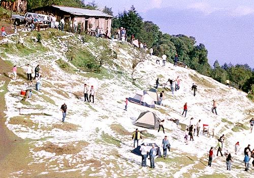
From November to February the temperature ranges between −6 °C (21 °F) and 10 °C (50 °F) (lowest recorded, in January 1956) and in the rest of the year the temperature ranges between 5 °C (41 °F) and 17 °C (63 °F). It is the coldest place in El Salvador. On 13 April 2004, much of the mountain was blanketed by an accumulation of hail during a storm, an unusual event that caused a commotion among the local community.
Adapted from Wikipedia: Cerro El Pital (CC BY-SA 4.0).
- Elevation
- 2,730 m (8,957 ft)
- Global rank
- #290 of 641 indexed
- Region
- North America (#64)
- Subregion
- Central America
- Countries
- El Salvador, Honduras
- Coordinates
- 14.3801°, -89.1200°
Of the 641 named summits indexed in YearMaps, Cerro El Pital ranks #290 by elevation, below Paektu-san (2,744 m) and above Jabal Hamoyet (2,726 m).
- Ranges:
- Sierra Madre Oriental (North America), Ouachita Mountains (North America)
- Neighbouring summits:
- Cerro Las Minas (2,849 m), Pico Mogotón (2,106 m)
- Settlements below:
- Santa Rosa de Copán (57 km), Comayagua (159 km), San Pedro Sula (171 km)
More about Cerro El Pital
Cerro El Pital: Key Facts
| Topographic prominence | 1,530 m |
|---|---|
| Mountain range | Sierra Madre de Chiapas |
Facts from Wikidata Q74214 (CC0).
Pico Mogotón
Mountain · 2,106 m
Pico Mogotón is a mountain rising to 2,106 metres (6,909 ft) in Nicaragua and Honduras, in the North America region. The summit stands on the border between them.
Mogotón is a mountain in the Reserva Nacional Cordillera Dipilto y Jalapa on the border of Nicaragua and Honduras; It rises 6,841 feet (2,085 m) above sea level and is the highest point in Nicaragua.
Adapted from Wikipedia: Mogotón (CC BY-SA 4.0).
- Elevation
- 2,106 m (6,909 ft)
- Global rank
- #398 of 641 indexed
- Region
- North America (#80)
- Subregion
- Central America
- Countries
- Nicaragua, Honduras
- Coordinates
- 13.7638°, -86.3914°
Of the 641 named summits indexed in YearMaps, Pico Mogotón ranks #398 by elevation, below Hvannadalshnkur (2,110 m) and above Gora Tardoki-Yani (2,090 m).
- Ranges:
- Sierra Madre Oriental (North America), Blue Ridge (North America)
- Neighbouring summits:
- Cerro Las Minas (2,849 m), Cerro El Pital (2,730 m)
- Settlements below:
- Tegucigalpa (97 km), Choluteca (101 km), Juticalpa (102 km)
More about Pico Mogotón
Pico Mogotón: Key Facts
| Mountain range | Cordillera dariense |
|---|
Facts from Wikidata Q2092378 (CC0).
Rivers in Honduras
3 rivers recorded. Listed alphabetically. A river is listed where its mapped reach lies, so long rivers appear under more than one country.
Ports in Honduras
8 ports recorded. Ranked by approach channel depth, the figure that limits which ships can call. Harbours link to their write-up on the page of the sea or coast they lie on.
| # | Name | Channel Depth | Class | Sea | Max Vessel |
|---|---|---|---|---|---|
| 1 | la Ceiba | 49.4 m | Very Small | Caribbean Sea | large vessels |
| 2 | Puerto de Hencan | 42.1 m | Very Small | Pacific Coast of North & Central America | large vessels |
| 3 | Puerto Este | 38.4 m | Very Small | Caribbean Sea | medium vessels |
| 4 | Puerto Castilla | 31.1 m | Very Small | Caribbean Sea | large vessels |
| 5 | Trujillo | 31.1 m | Very Small | Caribbean Sea | large vessels |
| 6 | Puerto Cortes | 27.4 m | Small | Caribbean Sea | large vessels |
| 7 | Coxen Hole | 12.8 m | Very Small | Caribbean Sea | large vessels |
| 8 | Tela | — | Very Small | Caribbean Sea | large vessels |
UNESCO World Heritage Sites in Honduras
2 World Heritage Sites recorded. Listed by year of inscription, earliest first. Sites shared with another country appear under each.
| # | Name | Inscribed | Type | Criteria |
|---|---|---|---|---|
| 1 | Copán | 1980 | Cultural | (iv) (vi) |
| 2 | Río Plátano Biosphere Reserve | 1982 | Natural | (vii) (viii) (ix) (x) |
Mountain Ranges, Deserts and Landforms of Honduras
2 mountain ranges, deserts and other landforms recorded. Ranked by mapped area. Covers mountain ranges, deserts, plateaus, named glaciers, plains, basins, peninsulas and capes. One that crosses a border is listed under every country it lies in, with the area of the whole feature.
| # | Name | Area | Type | Region |
|---|---|---|---|---|
| 1 | Central America | 787,235 km² | Isthmus | North America |
| 2 | Costa de los Mosquitos | 170 km² | Coast | North America |

Central America
Isthmus · 787,235 km²
Central America is an isthmus in North America (Central America), covering an estimated 787,235 km². It extends across Mexico, Nicaragua, Honduras, Guatemala, Panama, Costa Rica, El Salvador and Belize. It is the 20th-largest of the 231 landforms with a mapped extent in YearMaps.
Central America is a subregion of North America. Its political boundaries are defined as bordering Mexico to the north, Colombia to the southeast, the Caribbean to the east, and the Pacific Ocean to the southwest. Central America is usually defined as consisting of seven countries: Belize, Costa Rica, El Salvador, Guatemala, Honduras, Nicaragua, and Panama, and also, in specialized contexts, including Mexico. Within Central America is the Mesoamerican biodiversity hotspot, which extends from southern Mexico to southeastern Panama. Due to the presence of several active geologic faults and the Central America Volcanic Arc, seismic activity in the region, such as volcanic eruptions and earthquakes, is high, which has caused death, injury, and property damage.
Central America includes portions of two recognized cultural areas: the Isthmo-Colombian cultural area, which encompasses modern Panama, Costa Rica, and the eastern portions of Nicaragua and Honduras, along with regions to the east; and the Mesoamerican cultural area, encompassing Guatemala, Belize, El Salvador, and the western portions of Honduras and Nicaragua, along with the southern part of Mexico.
Adapted from Wikipedia: Central America (CC BY-SA 4.0).
- Feature class
- Isthmus
- Mapped extent
- 787,235 km²
- Size rank
- #20 of 231 landforms
- Region
- North America
- Subregion
- Central America
- Countries
- Mexico, Nicaragua, Honduras, Guatemala, Panama, Costa Rica, El Salvador, Belize
- Coordinates
- 13.8877°, -85.5972°
- Summits:
- Pico Mogotón (2,106 m), Cerro Las Minas (2,849 m), Cerro El Pital (2,730 m)
- Ranges:
- Sierra Madre Oriental (North America), Blue Ridge (North America)
- Settlements:
- Juticalpa (49 km), Tegucigalpa (101 km), La Ceiba (105 km)
More about Central America
Geography
Central America is a part of North America consisting of a tapering isthmus running from the southern extent of Mexico to the northwestern portion of South America. Central America has the Gulf of Mexico, a body of water within the Atlantic Ocean, to the north; the Caribbean Sea, also part of the Atlantic Ocean, to the northeast; and the Pacific Ocean to the southwest. Some physiographists define the Isthmus of Tehuantepec as the northern geographic border of Central America, while others use the northwestern borders of Belize and Guatemala. From there, the Central American land mass extends southeastward to the Atrato River, where it connects to the Pacific Lowlands in northwestern South America.
History
Central America was formed more than 3 million years ago, as part of the Isthmus of Panama, when its portion of land connected each side of water.
In the Pre-Columbian era, the northern areas of Central America were inhabited by the indigenous peoples of Mesoamerica. Most notable among these were the Mayans, who had built numerous cities throughout the region, and the Aztecs, who had created a vast empire. The pre-Columbian cultures of eastern Honduras, Caribbean Nicaragua, most of Costa Rica and Panama were predominantly speakers of the Chibchan languages at the time of European contact and are considered by some culturally different and grouped in the Isthmo-Colombian Area.
Economy
Signed in 2004, the Central American Free Trade Agreement (CAFTA) is an agreement between the United States, Costa Rica, El Salvador, Guatemala, Honduras, Nicaragua, and the Dominican Republic. The treaty is aimed at promoting free trade among its members.
Guatemala has the largest economy in the region. Its main exports are coffee, sugar, bananas, petroleum, clothing, and cardamom. Of its 10.29 billion dollar annual exports, 40.2% go to the United States, 11.1% to neighboring El Salvador, 8% to Honduras, 5.5% to Mexico, 4.7% to Nicaragua, and 4.3% to Costa Rica.
The region is particularly attractive for companies (especially clothing companies) because of its geographical proximity to the United States, very low wages and considerable tax advantages.
Sections adapted from Wikipedia: Central America (CC BY-SA 4.0).
Central America: Key Facts
| Area | 560,988 km² |
|---|---|
| Highest point | Volcán Tajumulco |
Facts from Wikidata Q27611 (CC0).
Countries Bordering Honduras
Land and maritime neighbours.
More Maps in North America
Honduras: Quick Answers
- What is the capital of Honduras?
- The capital of Honduras is Tegucigalpa.
- What is the population of Honduras?
- Honduras has a population of about 11.01 million, the #87 largest of 225 countries in YearMaps. Source: World Bank, 2025.
- How big is Honduras?
- Honduras covers 112,492 km², ranking #104 by area, with about 98 people per square kilometre.
- Which continent is Honduras in?
- Honduras is in North America.
- Which countries border Honduras?
- Honduras shares a land or maritime border with Guatemala, El Salvador, Nicaragua.
- What is the largest city in Honduras?
- Tegucigalpa is the largest city in Honduras, with a metropolitan population of about 946,000.
- What is the highest mountain in Honduras?
- The highest summit recorded for Honduras in YearMaps is Cerro Las Minas at 2,849 m (9,347 ft). Summits on a border are counted for both countries.