
Map of Ireland
Ireland is a country in Europe with its capital at Dublin, home to about 5.48 million people across 69,797 km². The interactive map below plots 15 cities and towns, 1 rivers, 3 lakes, 1 mountain summits and 20 ports recorded for Ireland in YearMaps.
- Population
- 5.48 million
- Area
- 69,797 km²
- Capital
- Dublin
- Continent
- Europe
Interactive Map of Ireland
Centred on Dublin at 53.3350° N, 6.2508° W. Use the layer panel to switch on rivers, dams, ports, peaks and historical borders.
About Ireland
Ireland (Irish: Éire [ˈeːɾʲə] ), also known as the Republic of Ireland (Poblacht na hÉireann), is a country in Northwestern Europe. It consists of 26 of the 32 counties of the island of Ireland, with a population of about 5.4 million. Its capital and largest city is Dublin, on the eastern side of the island, with a population of over 1.5 million. The sovereign state shares its only land border with Northern Ireland, which is part of the United Kingdom. It is otherwise surrounded by the Atlantic Ocean, with the Celtic Sea to the south, St George's Channel to the south-east and the Irish Sea to the east. It is a unitary, parliamentary republic. The legislature, the Oireachtas, consists of a lower house, Dáil Éireann; an upper house, Seanad Éireann; and an elected president (Uachtarán) who serves as the largely ceremonial head of state, but with some important powers and duties. The head of government is the Taoiseach (prime minister, lit. 'chief'), elected by the Dáil and appointed by the president, who appoints other government ministers.
The Irish Free State was created with Dominion status in 1922, following the Anglo-Irish Treaty. In 1937, a new constitution was adopted, in which the state was named "Ireland" and effectively became a republic, with an elected non-executive president. It was officially declared a republic in 1949, following The Republic of Ireland Act 1948. Ireland became a member of the United Nations in 1955. It joined the European Communities (EC), the predecessor of the European Union (EU), in 1973. The state had no formal relations with Northern Ireland for most of the 20th century, but the 1980s and 1990s saw the British and Irish governments working with Northern Irish parties to resolve the conflict that had become known as the Troubles. Since the signing of the Good Friday Agreement in 1998, the Irish government and Northern Irish government have co-operated on a number of policy areas under the North/South Ministerial Council created by the Agreement.
Ireland is a developed country with a quality of life ranked sixth in the world by the 2024 Human Development Index Report adjusted for inequality. It also ranks highly in healthcare, economic freedom and freedom of the press. According to the Global Peace Index, Ireland was the second most peaceful country worldwide in 2024.
It is a member of the EU and a founding member of the Council of Europe and the OECD.
Summary adapted from Wikipedia: Republic of Ireland (CC BY-SA 4.0).

Geography and Climate of Ireland
Celtic tribes arrived in Ireland between 600 and 150 B.C. Norse invasions that began in the late 8th century finally ended when King Brian BORU defeated the Danes in 1014. Norman invasions began in the 12th century and set off more than seven centuries of Anglo-Irish struggle marked by fierce rebellions and harsh repressions. The Irish famine of the mid-19th century caused an almost 25-percent decline in the island's population through starvation, disease, and emigration. The population of the island continued to fall until the 1960s, but over the last 50 years, Ireland's high birthrate has made it demographically one of the youngest populations in the EU. The modern Irish state traces its origins to the failed 1916 Easter Monday Uprising that galvanized nationalist sentiment. The ensuing guerrilla war led to independence from the UK in 1921 with the signing of the Anglo-Irish Treaty and the creation of the Irish Free State. The treaty was deeply controversial in Ireland, in part because it helped solidify the country's partition, with six of the 32 counties remaining in the UK as Northern Ireland. The split between pro-Treaty and anti-Treaty partisans led to the Irish Civil War (1922-23). The traditionally dominant political parties in Ireland, Fine Gael and Fianna Fail, are de facto descendants of the opposing sides of the treaty debate. Ireland declared itself a republic in 1949 and formally left the British Dominion. Beginning in the 1960s, deep sectarian divides between the Catholic and Protestant populations and systemic discrimination in Northern Ireland erupted into years of violence known as the Troubles. In 1998, the governments of Ireland and the UK, along with most political parties in Northern Ireland, reached the Belfast/Good Friday Agreement with the support of the US. This agreement helped end the Troubles and initiated a new phase of cooperation between the Irish and British Governments. Ireland was neutral in World War II and continues its policy of military neutrality. Ireland joined the European Community in 1973 and the euro-zone currency union in 1999. The economic boom years of the Celtic Tiger (1995-2007) saw rapid economic growth that came to an abrupt end in 2008 with the meltdown of the Irish banking system. As a small, open economy, Ireland has excelled at courting foreign direct investment, especially from US multi-nationals, which has helped the economy recover from the financial crisis and insulated it somewhat from the economic shocks of the COVID-19 pandemic.
- Location
- Western Europe, occupying five-sixths of the island of Ireland in the North Atlantic Ocean, west of Great Britain.
- Climate
- Temperate maritime; modified by North Atlantic Current; mild winters, cool summers; consistently humid; overcast about half the time.
- Terrain
- Mostly flat to rolling interior plain surrounded by rugged hills and low mountains; sea cliffs on west coast.
- Highest point
- Carrauntoohil 1,041 m.
- Lowest point
- Atlantic Ocean 0 m.
- Coastline
- 1,448 km.
- Land borders
- Total: 490 km; border countries: UK 499 km.
- Natural resources
- Natural gas, peat, copper, lead, zinc, silver, barite, gypsum, limestone, dolomite.
- Land use
- Agricultural land: 60.8% (2023 est.); arable land: 6.4% (2023 est.); permanent crops: 0% (2023 est.); permanent pasture: 54.4% (2023 est.); forest: 11.9% (2023 est.); other: 27.3% (2023 est.)
- Natural hazards
- Rare extreme weather events.
- Geographic note
- Strategic location on major air and sea routes between North America and northern Europe; over 40% of the population resides within 100 km of Dublin.
- Languages
- English (official, the language generally used), Irish (Gaelic or Gaeilge) (official, spoken by approximately 37.7% of the population)
- Religions
- Roman Catholic 69.2% (includes lapsed), Protestant 3.7% (Church of Ireland/England/Anglican/Episcopalian 2.5%, other Protestant 1.2%), Orthodox 2%, other Christian 0.9%, Muslim 1.6%, other 1.4%, agnostic/atheist 0.1%, none 14.5%, unspecified 6.7% (2022 est.)
- Ethnic groups
- Irish 76.6%, Irish travelers 0.6%, other White 9.9%, Asian 3.3%, Black 1.5%, other (includes Arab, Roma, and persons of mixed backgrounds) 2%, unspecified 2.6% (2022 est.)
- Economy
- High-income, export-oriented EU economy; large multinational business sector contributes to growth and tax revenues but poses volatility risks; high living standards; strong labor market challenged by skill shortages and aging workforce.
From the CIA World Factbook (public domain), archived edition of 2026-01-22. The Factbook is no longer updated, so figures reflect that edition.
Ireland in Numbers
- Population
- 5.48 million
- GDP
- US$721.7 billion
- GDP per person
- US$131,592
- Life expectancy
- 83.0 years
- Population growth
- 1.63% a year
- Population density
- 78 per km²
- Urban population
- 64.6%
- Surface area
- 70,280 km²
- Forest cover
- 12.0%
- Arable land
- 6.3%
- Access to electricity
- 100.0%
- Internet users
- 97.2%
Indicators from World Bank Open Data (CC BY 4.0). The year under each figure is its reference year.
Ireland in Depth
History
From the Act of Union on 1 January 1801, until 6 December 1922, the island of Ireland was part of the United Kingdom of Great Britain and Ireland. During the Great Famine, from 1845 to 1849, the island's population of over 8 million fell by 30%. One million Irish died of starvation and disease and another 1.5 million emigrated, mostly to the United States. This set the pattern of emigration for the century to come, resulting in constant population decline up to the 1960s.
From 1874, and particularly under Charles Stewart Parnell from 1880, the Irish Parliamentary Party gained prominence.
Geography
The state extends over an area of about five-sixths (70,273 km2 or 27,133 sq mi) of the island of Ireland (84,421 km2 or 32,595 sq mi), with Northern Ireland constituting the remainder. The island is bounded to the north and west by the Atlantic Ocean and to the northeast by the North Channel. To the east, the Irish Sea connects to the Atlantic Ocean via St George's Channel and the Celtic Sea to the southwest.
The western landscape mostly consists of rugged cliffs, hills and mountains. The central lowlands are extensively covered with glacial deposits of clay and sand, as well as significant areas of bogland and several lakes. The highest point is Carrauntoohil (1,038.6 m or 3,407 ft), located in the MacGillycuddy's Reeks mountain range in the southwest.
Economy
Ireland is an open economy and ranks first for "high-value" foreign direct investment (FDI) flows. Ireland ranks 5th of 187 (IMF) and 6th of 175 (World Bank) in GDP per capita as well as ranking in the top ten for GNI per capita. An alternative metric, known as modified gross national income (GNI), was created by the Central Statistics Office and is used by the Irish government to give a view of activity in the domestic economy after stripping out large multinational export movements which can often relate to intangible assets. This is particularly relevant in Ireland's economy, as GDP disproportionately includes income from non-Irish owned companies, which often flows out of Ireland.
Demographics
Genetic research suggests that the earliest settlers migrated from Iberia following the most recent ice age. After the Mesolithic, Neolithic and Bronze Age, migrants introduced a Celtic language and culture. Migrants from the two latter eras still represent the genetic heritage of most Irish people. Gaelic tradition expanded and became the dominant form over time. Irish people are a combination of Gaelic, Norse, Anglo-Norman, French, and British ancestry.
The population of Ireland was recorded as 5,149,139 in 2022, an increase of 8% since 2016. In 2011, Ireland had the highest birth rate in the European Union (16 births per 1,000 of population). In 2014, 36.3% of births were to unmarried women.
Sections adapted from Wikipedia: Republic of Ireland (CC BY-SA 4.0).
Ireland: Key Facts
| Official languages | Irish, English |
|---|---|
| Head of state | Catherine Connolly |
| Head of government | Micheál Martin |
| Form of government | parliamentary republic, unitary state |
| Calling code | +353 |
| Internet domain | .ie |
| Highest point | Carrauntoohil |
| Lowest point | North Slob |
| Established | 29 December 1937 |
Facts from Wikidata Q27 (CC0).
History of Ireland: Empires and States
The atlas records 10 polities whose mapped territory included part of Ireland, from Viking settlements in 850 CE to 2024 CE. They are listed in the order they first appear.
| Polity | Period here | Extent |
|---|---|---|
| Viking settlements | 850–1325 CE | A large part |
| Angevin Empire | 1177–1209 CE | A large part |
| Kingdom of England | 1177–1708 CE | Nearly all |
| Earldom of Desmond | 1352–1458 CE | A large part |
| Irish Catholic Confederation | 1642–1652 CE | A large part |
| Commonwealth of England | 1648–1661 CE | Nearly all |
| The British Empire | 1709–1921 CE | Nearly all |
| Kingdom of Great Britain | 1709–1921 CE | Nearly all |
| Irish Free State | 1922–1937 CE | Nearly all |
| Éire | 1938–2024 CE | Nearly all |
Historical Maps of Ireland
Ireland on the world map in each year one of these states held it:
Derived by testing mapped cities against dated territorial polygons. Dates are when the polygons cover this place, not the polity's whole lifespan, and polities absent from the source dataset are not listed.
Largest Cities in Ireland
15 cities recorded. Ranked by metropolitan population. A port city's harbour is written up on the page of its sea.
| # | Name | Population | Region | Role |
|---|---|---|---|---|
| 1 | Dublin | 1.06 million | Dublin | National capital |
| 2 | Cork | 188,907 | Cork | Populated place |
| 3 | Limerick | 90,054 | Limerick | Populated place |
| 4 | Galway | 75,594 | Galway | Populated place |
| 5 | Waterford | 49,275 | Kilkenny | Populated place |
| 6 | Dundalk | 38,884 | Louth | Admin-1 capital |
| 7 | Drogheda | 36,533 | Louth | Populated place |
| 8 | Tralee | 26,384 | Kerry | Admin-1 capital |
| 9 | Kilkenny | 21,589 | Kilkenny | Populated place |
| 10 | Sligo | 20,228 | Sligo | Populated place |
| 11 | Killarney | 11,902 | Kerry | Populated place |
| 12 | Shannon | 8,781 | Clare | Populated place |
| 13 | Muineachan | 5,937 | Monaghan | Admin-1 capital |
| 14 | Ros Comain | 4,860 | Roscommon | Admin-1 capital |
| 15 | Donegal | 2,513 | Donegal | Populated place |
Highest Mountains in Ireland
1 mountain recorded. Ranked by summit elevation above sea level. A summit on a border is listed under both countries.
| # | Name | Elevation | Feet | Region |
|---|---|---|---|---|
| 1 | Carrauntoohil | 1,038 m | 3,406 ft | Europe |
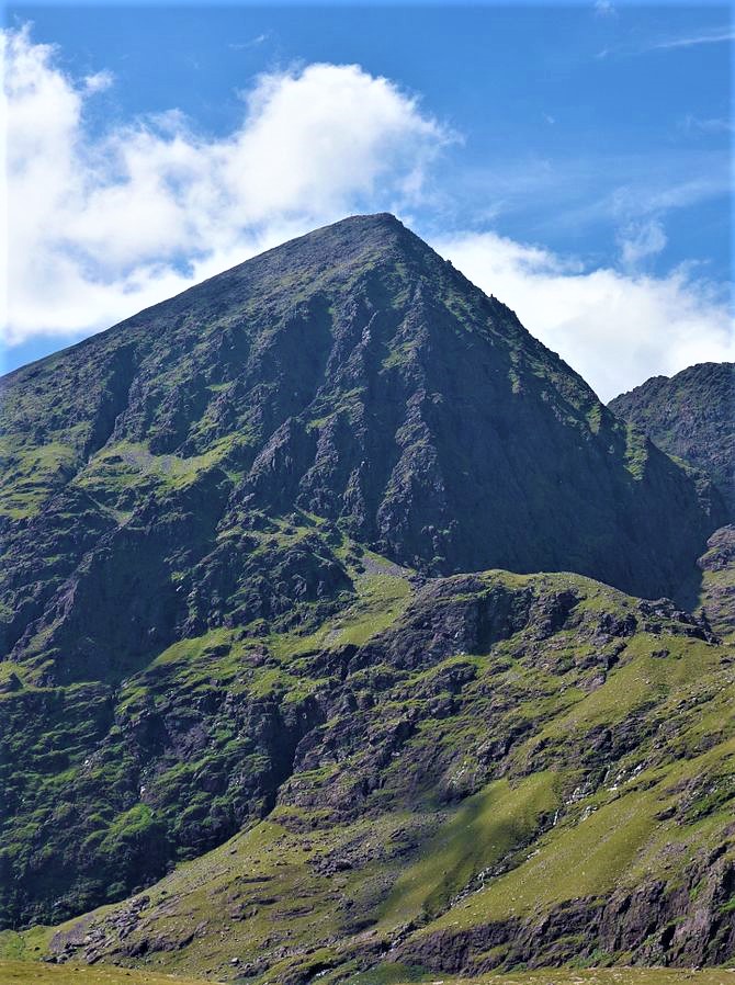
Carrauntoohil
Mountain · 1,038 m
Carrauntoohil is a mountain rising to 1,038 metres (3,406 ft) in Ireland, in the Europe region.
Carrauntoohil, Carrauntoohill or Carrantuohill (, KARR-ən-TOO-əl; Irish: Corrán Tuathail [ˌkɔɾˠaːn̪ˠ ˈt̪ˠuəhəlʲ], meaning "Tuathal's sickle") is the highest mountain in Ireland at 1,038.6 metres (3,407 feet 6 inches). It is on the Iveragh Peninsula in County Kerry, close to the centre of Ireland's highest mountain range, MacGillycuddy's Reeks. Carrauntoohil is composed mainly of sandstone, whose glaciation produced distinctive features on the mountain such as the Eagle's Nest corrie and some deep gullies and sharp arêtes in its east and northeastern faces that are popular with rock and winter climbers.
As Ireland's highest mountain, Carrauntoohil is popular with mountain walkers, who most commonly ascend via the Devil's Ladder route; however, Carrauntoohil is also climbed as part of longer mountain walking routes in the MacGillycuddy's Reeks range, including the 15-kilometre (9+1⁄2 mi) Coomloughra Horseshoe or the 26-kilometre (16 mi) MacGillycuddy's Reeks Ridge Walk of the entire mountain range. Carrauntoohil, and most of the range is held in private ownership and is not part of any Irish national park; however, reasonable access is granted to the public for recreational use.
Adapted from Wikipedia: Carrauntoohil (CC BY-SA 4.0).
- Elevation
- 1,038 m (3,406 ft)
- Global rank
- #554 of 641 indexed
- Region
- Europe (#64)
- Subregion
- British Isles
- Country
- Ireland
- Coordinates
- 51.9990°, -9.7427°
Of the 641 named summits indexed in YearMaps, Carrauntoohil ranks #554 by elevation, below Mowdok Mual (1,052 m) and above Selvili Tepe (1,023 m).
- Ranges:
- Cambrian Mountains (Europe), Grampian Mountains (Europe)
More about Carrauntoohil
Geography
Carrauntoohil is the central peak of the MacGillycuddy's Reeks range, and has three major ridges. A narrow rocky ridge, or arête, to the north, known as the Beenkeragh Ridge, contains the summit of The Bones (Na Cnámha), and leads to Ireland's second-highest peak, Beenkeragh (Binn Chaorach) at 1,008 m (3,307 ft). The ridge westward, called the Caher Ridge, also an arête, leads to Ireland's third-highest peak, Caher at 1,000 m (3,300 ft). A third and much wider unnamed south-easterly ridge, or spur, leads down to a col where sits the top of the Devil's Ladder (the classic access route for Carrauntoohil from the Hag's Glen), but then rises back up to Cnoc na Toinne 845 m (2,772 ft), from which the long easterly ridge section of MacGillycuddy's Reeks is accessed.
Geology
Carrauntoohil is composed of sandstone particles of various sizes which are collectively known as Old Red Sandstone. Old Red Sandstone has a purple-reddish colour (stained green in places), and has virtually no fossils; it dates from the Devonian period (410 to 350 million years ago) when Ireland was in a hot equatorial climate. The sedimentary rocks of the Iveragh Peninsula are composed of three layers that are up to 7 kilometres (4+1⁄2 mi) thick (in ascending order): Lough Acoose Formation, Chloritic Sandstone Formation, and the Ballinskelligs Sandstone Formation.
Carrauntoohil was later subject to significant glaciation during the last ice age, the result of which is deep fracturing of the rock, and the surrounding of Carrauntoohil by U-shaped valleys, sharp arêtes, and deep corries.
Sections adapted from Wikipedia: Carrauntoohil (CC BY-SA 4.0).
Carrauntoohil: Key Facts
| Topographic prominence | 1,039 m |
|---|---|
| Mountain range | MacGillycuddy's Reeks |
Facts from Wikidata Q503368 (CC0).
Largest Lakes in Ireland
3 lakes recorded. Ranked by mapped surface area. A lake on a border is listed under each country it lies in, with the area of the whole lake.
| # | Name | Surface Area | Type |
|---|---|---|---|
| 1 | Lough Derg | 136 km² | Lake |
| 2 | Lough Ree | 111 km² | Lake |
| 3 | Lough Allen | 36 km² | Lake |

Lough Ree
Lake · 111 km²
Lough Ree is a lake in Ireland, with a mapped surface area of about 111 km².
Lough Ree (Irish: Loch Rí), translated to English as King's Lake or King Lake,is a lake in the midlands of Ireland, the second of the three major lakes on the River Shannon. Lough Ree is the second largest lake on the Shannon after Lough Derg. The other two major lakes are Lough Allen to the north, and Lough Derg to the south. There are also several minor lakes along the length of the river. The lake serves as a border between the counties of Longford and Westmeath (both in the province of Leinster) on the eastern side and County Roscommon in the province of Connacht on the western side. The lake is popular for fishing and boating. The lake supports a small commercial eel fishery and is locally famous for its eels on wheels truck. The town of Athlone is situated at the southern end of the lake, and has a harbour for boats going out on the lake. The small town of Lanesboro is at the northern end of the lake.
The island of Inchcleraun (Inis Cloithreann) in the northern part of the lake is the site of a monastery founded in the early Christian era and contains the remains of several ancient churches. In Irish legends, it was on this island that Queen Maeve was killed.
Adapted from Wikipedia: Lough Ree (CC BY-SA 4.0).
- Surface area
- 111 km²
- Area rank
- #596 of 756 indexed
- Type
- Lake
- Country
- Ireland
- Coordinates
- 53.5196°, -7.9475°
Among the 756 water bodies with a mapped extent in YearMaps, Lough Ree ranks #596 by surface area, after Sebago Lake (111 km²) and ahead of Ozero Chrtovo (111 km²). Areas are computed from the mapped outline and are approximate.
- Watercourses:
- Caledonian Canal (River), Thames (River)
- Other water nearby:
- Lough Allen (36 km²), Upper Lough Erne (51 km²)
More about Lough Ree
Human history
9th century Viking attacks climaxed in 845 in Ireland and they built a fortified base on Lough Ree.
AI907.1 Kl. The plundering of Lough Rí by the men of Mumu as far as Mairg Laigen and Mag Léna, as a result of which Mael Craíbe son of Cathalán, king of Cenél Fiachrach, and many others were slain.
AI922.2 Tomrair son of Elgi, a Jarl of the foreigners, on Luimnech (the Lower Shannon), and he proceeded and plundered Inis Celtra and Muicinis, and burned Cluain Moccu Nóis; and he went on Loch Rí and plundered all its islands, and he ravaged Mide.
M934.6.Amhlaibh Ceannchairech, with the foreigners, came from Loch Eirne across Breifne to Loch Ribh. On the night of Great Christmas they reached the Sinainn, and they remained seven months there; and Magh-Aei was spoiled and plundered by them.
Ecology
Lough Ree has been designated a Special Area of Conservation. The main habitat, by area, is the lake itself, but there are other habitats including bog.
Lough Ree site has been designated a Special Protection Area on the basis of its migratory waterfowl, with nationally important numbers of Tachybaptus ruficollis.
In 2021, invasive quagga mussels were discovered in the lake and in Lough Derg by a research team from UCD.
Sections adapted from Wikipedia: Lough Ree (CC BY-SA 4.0).
Lough Ree: Key Facts
| Surface area | 105 km² |
|---|---|
| Maximum depth | 35 m |
| Surface elevation | 38 m |
| Inflows | River Shannon, River Inny |
| Outflows | River Shannon |
| Drainage system | Shannon River Basin |
Facts from Wikidata Q608133 (CC0).

Lough Allen
Lake · 36 km²
Lough Allen is a lake in Ireland, with a mapped surface area of about 36 km².
Lough Allen (Irish: Loch Aillionn) is a lake on the River Shannon in northeastern Connacht, Ireland. Most of the lake is in County Leitrim, with a smaller part in County Roscommon. The lake lies to the south of the River Shannon's source, near the Iron Mountains, and is the uppermost of the three main lakes on the river. The other two, Lough Ree and Lough Derg are much further to the south.
Adapted from Wikipedia: Lough Allen (CC BY-SA 4.0).
- Surface area
- 36 km²
- Area rank
- #733 of 756 indexed
- Type
- Lake
- Country
- Ireland
- Coordinates
- 54.1359°, -8.0545°
Among the 756 water bodies with a mapped extent in YearMaps, Lough Allen ranks #733 by surface area, after Lake Coleridge (36 km²) and ahead of Lake Walcott (34 km²). Areas are computed from the mapped outline and are approximate.
- Settlements on the shore:
- Sligo (31 km), Omagh (71 km), Londonderry (107 km)
- Watercourses:
- Caledonian Canal (River), Thames (River)
- Other water nearby:
- Upper Lough Erne (51 km²), Lough Ree (111 km²)
More about Lough Allen
Geography
Lough Allen, out of which the Shannon takes its source, is nine miles long, and three miles wide. The lake is shaped like an isosceles triangle. The Shannon enters the lake at the wider northern end and leaves the lake at the narrow southern end. Other rivers that feed the lake include the Diffagher (northwest), the Yellow (northeast), the Stoney (east) and the Arigna (southwest). The R280 regional road skirts the west side of the lake, while the R207 follows the east bank, from Ballinagleragh to Drumshanbo. The R200 road is on the north side of the lake, traveling west from Dowra to Drumkeeran. Slieve Anierin lie to the east of Lough Allen. There has been speculation that notable reserves of oil and gas lie beneath the Allen basin.
History
Iron ore has been extracted at Slieve Anierin for millennia. From the early 17th century a number of mines and works were conveniently contiguous to Lough Allen, allowing for the transportation of iron ore over water to the ironworks in boats of up to forty tons. During the Irish Rebellion of 1641 nearly all ironworks were destroyed, but many were revived by the English after the Irish Confederate Wars. Extensive forests around Lough Allen before the 17th century were denuded to make charcoal for ironworks, the industry later collapsing in the 19th century.
On the construction of the Shannon hydroelectric scheme in 1925–9, the lake became a storage reservoir for the power station nearly 100 miles away, with sluices to control the flow into the river.
Ecology
Between c. 2001 – c. 2003, water quality was reported to be excellent with an oligotrophic rating. The pike population is the "native Irish strain" (Irish: liús meaning 'Irish Pike') not the other European Pike strain (Irish: gailliasc meaning 'strange or foreign fish'). The ecology of Lough Allen, and other Irish waterways, remain threatened by curly waterweed, zebra mussel, and freshwater clam invasive species.
Sections adapted from Wikipedia: Lough Allen (CC BY-SA 4.0).
Lough Allen: Key Facts
| Surface area | 36 km² |
|---|---|
| Maximum depth | 31 m |
| Inflows | River Shannon |
| Outflows | River Shannon |
Facts from Wikidata Q1366974 (CC0).
Rivers in Ireland
1 river recorded. Listed alphabetically. A river is listed where its mapped reach lies, so long rivers appear under more than one country.
| Name | Type | Also Flows Through |
|---|---|---|
| Shannon | Lake reach | — |
Ports in Ireland
20 ports recorded. Ranked by approach channel depth, the figure that limits which ships can call. Harbours link to their write-up on the page of the sea or coast they lie on.
| # | Name | Channel Depth | Class | Sea | Max Vessel |
|---|---|---|---|---|---|
| 1 | Westport | 56.7 m | Very Small | Irish Sea & Celtic Sea | point_of_interest |
| 2 | Limerick | 56.7 m | Small | Irish Sea & Celtic Sea | medium vessels |
| 3 | Sligo | 56.7 m | Very Small | Irish Sea & Celtic Sea | medium vessels |
| 4 | Galway | 53 m | Very Small | Irish Sea & Celtic Sea | medium vessels |
| 5 | Greenore | 49.4 m | Very Small | Irish Sea & Celtic Sea | large vessels |
| 6 | Kilrush | 49.4 m | Very Small | Irish Sea & Celtic Sea | medium vessels |
| 7 | Fenit | 49.4 m | Very Small | Irish Sea & Celtic Sea | medium vessels |
| 8 | Valentia | 49.4 m | Very Small | Irish Sea & Celtic Sea | medium vessels |
| 9 | New Ross | 49.4 m | Small | Irish Sea & Celtic Sea | medium vessels |
| 10 | Waterford | 49.4 m | Very Small | Irish Sea & Celtic Sea | large vessels |
The other 10 (channel depth, class, sea, max vessel)
- Drogheda · 49.4 m · Very Small · Irish Sea & Celtic Sea · medium vessels
- Foynes · 45.7 m · Major · Irish Sea & Celtic Sea · large vessels
- Rosslare · 45.7 m · Small · Irish Sea & Celtic Sea · medium vessels
- Castletown Bearhaven · 42.1 m · Very Small · Irish Sea & Celtic Sea · medium vessels
- Bantry · 38.4 m · Very Small · Irish Sea & Celtic Sea · large vessels
- Rathmullan · 38.4 m · Very Small · Irish Sea & Celtic Sea · point_of_interest
- Dublin · 38.4 m · Minor · Irish Sea & Celtic Sea · large vessels
- Cobh · 34.7 m · Minor · Irish Sea & Celtic Sea · medium vessels
- Tarbert · 16.5 m · Very Small · Irish Sea & Celtic Sea · large vessels
- Killybegs · 5.5 m · Very Small · Irish Sea & Celtic Sea · large vessels
UNESCO World Heritage Sites in Ireland
2 World Heritage Sites recorded. Listed by year of inscription, earliest first. Sites shared with another country appear under each.
| # | Name | Inscribed | Type | Criteria |
|---|---|---|---|---|
| 1 | Brú na Bóinne | 1993 | Cultural | (i) (iii) (iv) |
| 2 | Skellig Michael | 1996 | Cultural | (iii) (iv) |
Largest Islands of Ireland
2 islands recorded. Ranked by mapped area. An island divided between countries is listed under each, with the area of the whole island.
| # | Name | Area | Type |
|---|---|---|---|
| 1 | British Isles | 543,325 km² | Island group |
| 2 | Ireland | 83,066 km² | Island |

British Isles
Island group · 543,325 km²
British Isles is an island group in Europe (British Isles), covering an estimated 543,325 km². It extends across the United Kingdom, Ireland and Isle of Man. It is the 18th-largest of the 445 islands with a mapped extent in YearMaps.
The British Isles, also called "these islands" in diplomatic settings, are an archipelago in the North Atlantic Ocean off the north-western coast of continental Europe, consisting of the islands of Great Britain, Ireland, the Isle of Man, the Inner and Outer Hebrides, the Northern Isles (Orkney and Shetland), and over six thousand smaller islands. They have a total area of 315,159 km2 (121,684 sq mi) and a combined population of almost 75 million, and include two sovereign states, the Republic of Ireland (which covers roughly five-sixths of Ireland) and the United Kingdom of Great Britain and Northern Ireland. The Channel Islands, off the north coast of France, are normally taken to be part of the British Isles, even though geographically they do not form part of the archipelago. Under the UK Interpretation Act 1978, the Channel Islands are clarified as forming part of the British Islands, not to be confused with the British Isles.
The oldest rocks are 2.7 billion years old and are found in Ireland, Wales and the north-west of Scotland. During the Silurian period, the north-western regions collided with the south-east, which had been part of a separate continental landmass.
Adapted from Wikipedia: British Isles (CC BY-SA 4.0).
- Feature class
- Island group
- Mapped extent
- 543,325 km²
- Size rank
- #18 of 445 islands
- Region
- Europe
- Subregion
- British Isles
- Countries
- United Kingdom, Ireland, Isle of Man
- Coordinates
- 54.0510°, -4.2765°
- Summits:
- Carrauntoohil (1,038 m)
- Ranges:
- Cambrian Mountains (Europe), Grampian Mountains (Europe)
More about British Isles
Geography
The British Isles lie at the juncture of several regions with past episodes of tectonic mountain building. These orogenic belts form a complex geology that records a huge and varied span of Earth's history. Of particular note was the Caledonian orogeny during the Ordovician and early Silurian periods, when the craton Baltica collided with the terrane Avalonia to form the mountains and hills in northern Britain and Ireland. Baltica formed roughly the north-western half of Ireland and Scotland. Further collisions caused the Variscan orogeny in the Devonian and Carboniferous periods, forming the hills of Munster, south-west England, and southern Wales.
History
2.5 million years ago, the British Isles were repeatedly submerged beneath an ice sheet that extended into the middle of the North Sea, with a larger ice sheet that covered a significant proportion of Scandinavia on the opposite side. Around 1.9 million years ago, these two ice sheets frequently merged, essentially creating a land bridge between Scandinavia and northern Great Britain. Further south was a direct land bridge, now known as Doggerland, which was gradually submerged as sea levels rose. However, the Irish Sea was formed before Doggerland was completely covered in water, with Ireland becoming an island roughly 6,000 years before Great Britain did.
Demographics
England has a generally high population density, with almost 80% of the total population of the islands. Elsewhere in Great Britain and Ireland, high density of population is limited to areas around a few large cities. The largest urban area by far is the Greater London Built-up Area with 9 million inhabitants. Other major population centres include the Greater Manchester Built-up Area (2.4 million), West Midlands conurbation (2.4 million) and West Yorkshire Urban Area (1.6 million) in England, Greater Glasgow (1.2 million) in Scotland and Greater Dublin Area (1.9 million) in Ireland.
Sections adapted from Wikipedia: British Isles (CC BY-SA 4.0).
British Isles: Key Facts
| Area | 315,160 km² |
|---|---|
| Population | 71,891,524 (2019) |
| Highest point | Ben Nevis |
| Surrounded by | Atlantic Ocean |
Facts from Wikidata Q38272 (CC0).
Visiting British Isles
Great Britain, Ireland and the rest of the British Isles lie just northwest of the European mainland. Together they form one of the most visited regions on Earth, containing some of the world's most recognisable landmarks, historical sites dating back thousands of years, and unique natural environments, world cities, quaint towns, and remote and isolated areas and islands.
Travel notes adapted from Wikivoyage: Britain and Ireland (CC BY-SA 4.0).

Ireland
Island · 83,066 km²
Ireland is an island in Europe (British Isles), covering an estimated 83,066 km². It extends across Ireland and the United Kingdom. About 80% of the island belongs to Ireland, and the rest to the United Kingdom.
Ireland is an island in the North Atlantic Ocean, in Northwestern Europe. Geopolitically, the island is divided between the Republic of Ireland (officially named Ireland – a sovereign state covering five-sixths of the island) and Northern Ireland (part of the United Kingdom – covering the remaining sixth). It is separated from Great Britain to its east by the North Channel, the Irish Sea, and St George's Channel. Ireland is the second-largest island of the British Isles, the third-largest in Europe, and the twentieth-largest in the world. As of 2022, the population of the entire island is just over 7 million, with 5.1 million in the Republic of Ireland and 1.9 million in Northern Ireland, ranking it the second-most populous island in Europe after Great Britain.
The geography of Ireland comprises relatively low-lying mountains surrounding a central plain, with several navigable rivers extending inland. Much of Ireland was woodland until the end of the Middle Ages. Today, woodland makes up about 10% of the island, compared with a European average of over 33%, with most of it being non-native conifer plantations.
Adapted from Wikipedia: Ireland (CC BY-SA 4.0).
- Feature class
- Island
- Mapped extent
- 83,066 km²
- Size rank
- #64 of 445 islands
- Region
- Europe
- Subregion
- British Isles
- Countries
- Ireland, United Kingdom
- Coordinates
- 53.0671°, -7.5266°
- Summits:
- Carrauntoohil (1,038 m)
- Ranges:
- Cambrian Mountains (Europe), Grampian Mountains (Europe)
More about Ireland
Geography
Ireland is located in the north-west of Europe, between latitudes 51° and 56° N, and longitudes 11° and 5° W. The island is separated from Great Britain by the Irish Sea and the North Channel, which has a width of 23 kilometres (14 mi) at its narrowest point. To the west is the northern Atlantic Ocean and to the south is the Celtic Sea, which lies between Ireland and Brittany, in France. Ireland has a total area of 84,421 km2 (32,595 mi2), of which the Republic of Ireland occupies 83 percent. Ireland and Great Britain, together with many nearby smaller islands, are known collectively as the British Isles. As the term British Isles can be controversial in relation to Ireland, the alternate term Britain and Ireland is sometimes used as a neutral term for the islands.
History
During the last glacial period, much of Ireland was periodically covered by ice sheets. The relative sea level was less than 50 m lower, resulting in an ice bridge rather than a land bridge forming between Ireland and Great Britain. By 14,000 BC this ice bridge existed only between Northern Ireland and Scotland and by 12,000 BC Ireland was completely separated from Great Britain. Later, around 6,100 BC, Great Britain became separated from continental Europe. Until recently, the earliest evidence of human activity in Ireland was dated at 12,500 years ago, demonstrated by a butchered bear bone found in a cave in County Clare.
Demographics
The population of Ireland is just over 7 million, of which approximately 5.1 million reside in the Republic of Ireland and 1.9 million reside in Northern Ireland.
People have lived in Ireland for over 9,000 years. Early historical and genealogical records note the existence of major groups such as the Cruthin, Corcu Loígde, Dál Riata, Dáirine, Deirgtine, Delbhna, Érainn, Laigin, Ulaid. Later major groups included the Connachta, Ciannachta, Eóganachta. Smaller groups included the aithechthúatha (see Attacotti), Cálraighe, Cíarraige, Conmaicne, Dartraighe, Déisi, Éile, Fir Bolg, Fortuatha, Gailenga, Gamanraige, Mairtine, Múscraige, Partraige, Soghain, Uaithni, Uí Maine, Uí Liatháin. Many survived into late medieval times, others vanished as they became politically unimportant.
Economy
The GDP of the Republic of Ireland as of 2021 was €423.5 billion (nominal), and in Northern Ireland in 2021, it was £52 billion (GVA Balanced). The GDP per capita in the Republic of Ireland was €84,049.9 (nominal) as of 2021, and in Northern Ireland 2021 was £27,154 (GVA Balanced). The Republic of Ireland and the United Kingdom measure these numbers differently.
Despite the two jurisdictions using two distinct currencies (the euro and pound sterling), a growing amount of commercial activity is carried out on an all-Ireland basis.
Sections adapted from Wikipedia: Ireland (CC BY-SA 4.0).
Ireland: Key Facts
| Area | 84,421 km² |
|---|---|
| Population | 7,185,600 (2023) |
| Highest point | Carrauntoohil |
| Surrounded by | Atlantic Ocean, Irish Sea |
Facts from Wikidata Q22890 (CC0).
Visiting Ireland
Ireland (Irish: Éire), also known as the Republic of Ireland (Irish: Poblacht na hÉireann), has a rich culture that, along with its people, has been exported around the world. Some Irish history has been very dark indeed, but it remains a land of poets, story-tellers, and musicians, with marvellous scenery, an advanced knowledge economy, first-rate infrastructure, and leading industries, with a high gross domestic product and standard of living. Ireland has historically been referred to as ‘The Land of Saints and Scholars’, reflecting its long standing religious affinities as well as its many contributions to the fields of poetry and literature.
Gaelic culture is alive and well; one way to experience it is to go to a pub which has a traditional music session on. The Irish language has declined and English is now the most common language, though there are still certain areas where Irish is frequently spoken. It can be worth your while to dig a little deeper before visiting Ireland to discover something about the older world that lies beneath.
Travel notes adapted from Wikivoyage: Ireland (CC BY-SA 4.0).
Countries Bordering Ireland
Land and maritime neighbours.
More Maps in Europe
Ireland: Quick Answers
- What is the capital of Ireland?
- The capital of Ireland is Dublin.
- What is the population of Ireland?
- Ireland has a population of about 5.48 million, the #122 largest of 225 countries in YearMaps. Source: World Bank, 2025.
- How big is Ireland?
- Ireland covers 69,797 km², ranking #122 by area, with about 79 people per square kilometre.
- Which continent is Ireland in?
- Ireland is in Europe.
- Which countries border Ireland?
- Ireland shares a land or maritime border with United Kingdom.
- What is the largest city in Ireland?
- Dublin is the largest city in Ireland, with a metropolitan population of about 1.06 million.
- What is the highest mountain in Ireland?
- The highest summit recorded for Ireland in YearMaps is Carrauntoohil at 1,038 m (3,406 ft). Summits on a border are counted for both countries.
- What is the largest lake in Ireland?
- The largest lake recorded in or bordering Ireland is Lough Derg, at roughly 136 km².