
Map of Malaysia
Malaysia is a country in Asia with its capital at Kuala Lumpur, home to about 35.98 million people across 330,803 km². The interactive map below plots 32 cities and towns, 4 rivers, 3 mountain summits and 30 ports recorded for Malaysia in YearMaps.
- Population
- 35.98 million
- Area
- 330,803 km²
- Capital
- Kuala Lumpur
- Continent
- Asia
Interactive Map of Malaysia
Centred on Kuala Lumpur at 3.1686° N, 101.6980° E. Use the layer panel to switch on rivers, dams, ports, peaks and historical borders.
About Malaysia
Malaysia is a country in Southeast Asia. A federal constitutional monarchy, it consists of 13 states and three federal territories, separated by the South China Sea into two regions: Peninsular Malaysia on Mainland Southeast Asia and East Malaysia on the island of Borneo. Peninsular Malaysia shares land and maritime borders with Thailand, as well as maritime borders with Singapore, Vietnam, and Indonesia; East Malaysia shares land borders with Brunei and Indonesia, and maritime borders with the Philippines and Vietnam. Kuala Lumpur is the country's national capital, largest city, and the seat of the legislative branch of the federal government, while Putrajaya is the federal administrative capital, representing the seat of both the executive branch and the judicial branch of the federal government. With a population of over 34 million, it is the world's 43rd-most populous country.
The country has its origins in the Malay kingdoms, which, from the 18th century on, became subject to the British Empire, along with the British Straits Settlements protectorate. During World War II, British Malaya, along with other nearby British and American colonies, was occupied by the Empire of Japan. Following three years of occupation, Malaya was briefly unified as the Malayan Union in 1946 until 1948 when it was restructured as the Federation of Malaya. The country achieved independence on 31 August 1957. On 16 September 1963, independent Malaya united with the then British crown colonies of North Borneo, Sarawak, and Singapore to become Malaysia. In August 1965, Singapore was separated from the federation and became an independent country.
Malaysia is tropical and is one of 17 megadiverse countries; it is home to numerous endemic species. The country is multiethnic and multicultural, which has a significant effect on its politics. About half the population is ethnically Malay, with minorities of Chinese, Indians, and indigenous peoples. The Bumiputra policy grants the Malay majority a constitutionally enshrined privileged status over Malaysian citizens who are Chinese or Indians via affirmative action measures. The official language is Malaysian Malay, a standard form of the Malay language. English remains an active second language. While recognising Islam as the official religion, the constitution grants freedom of religion to non-Muslims though conversion out of Islam is forbidden while conversion to it is allowed. The government is modelled on the Westminster parliamentary system, and the legal system is based on common law.
Summary adapted from Wikipedia: Malaysia (CC BY-SA 4.0).

Geography and Climate of Malaysia
Malaysia’s location has long made it an important cultural, economic, historical, social, and trade link between the islands of Southeast Asia and the mainland. Through the Strait of Malacca, which separates the Malay Peninsula from the archipelago, flowed maritime trade and with it influences from China, India, the Middle East, and the east coast of Africa. Prior to the 14th century, several powerful maritime empires existed in what is modern-day Malaysia, including the Srivijayan, which controlled much of the southern part of the peninsula between the 7th and 13th centuries, and the Majapahit Empire, which took control over most of the peninsula and the Malay Archipelago between the 13th and 14th centuries. The adoption of Islam between the 13th and 17th centuries also saw the rise of a number of powerful maritime states and sultanates on the Malay Peninsula and the island of Borneo, such as the port city of Malacca (Melaka), which at its height in the 15th century had a navy and hosted thousands of Chinese, Arab, Persian, and Indian merchants. The Portuguese in the 16th century and the Dutch in the 17th century were the first European colonial powers to establish themselves on the Malay Peninsula and in Southeast Asia. However, it was the British who ultimately secured hegemony across the territory and during the late 18th and 19th centuries established colonies and protectorates in the area that is now Malaysia. Japan occupied these holdings from 1942 to 1945. In 1948, the British-ruled territories on the Malay Peninsula (except Singapore) formed the Federation of Malaya, which became independent in 1957. Malaysia was formed in 1963 when the former British colonies of Singapore, as well as Sabah and Sarawak on the northern coast of Borneo, joined the Federation. A communist insurgency, confrontations with Indonesia, Philippine claims to Sabah, and Singapore's expulsion in 1965 marred the first several years of the country's independence. During the 22-year term of Prime Minister MAHATHIR Mohamad (1981-2003), Malaysia was successful in diversifying its economy from dependence on exports of raw materials to the development of manufacturing, services, and tourism. Former Prime Minister MAHATHIR and a newly formed coalition of opposition parties defeated Prime Minister Mohamed NAJIB bin Abdul Razak's United Malays National Organization (UMNO) in 2018, ending over 60 years of uninterrupted UMNO rule. From 2018-2022, Malaysia underwent considerable political upheaval, with a succession of coalition governments holding power. Following legislative elections in 2022, ANWAR Ibrahim was appointed prime minister after more than 20 years in opposition. His political coalition, Pakatan Harapan (PH), joined its longtime UNMO rival to form a government, but the two groups have remained deeply divided on many issues.
- Location
- Southeastern Asia, peninsula bordering Thailand and northern one-third of the island of Borneo, bordering Indonesia, Brunei, and the South China Sea, south of Vietnam.
- Climate
- Tropical; annual southwest (April to October) and northeast (October to February) monsoons.
- Terrain
- Coastal plains rising to hills and mountains.
- Highest point
- Gunung Kinabalu 4,095 m.
- Lowest point
- Indian Ocean 0 m.
- Coastline
- 4,675 km (Peninsular Malaysia 2,068 km; East Malaysia 2,607 km)
- Land borders
- Total: 2,742 km; border countries: Brunei 266 km; Indonesia 1,881 km; Thailand 595 km.
- Natural resources
- Tin, petroleum, timber, copper, iron ore, natural gas, bauxite.
- Land use
- Agricultural land: 26.1% (2023 est.); arable land: 2.4% (2023 est.); permanent crops: 22.7% (2023 est.); permanent pasture: 0.9% (2023 est.); forest: 57.8% (2023 est.); other: 16% (2023 est.)
- Natural hazards
- Flooding; landslides; forest fires.
- Geographic note
- Strategic location along Strait of Malacca and southern South China Sea.
- Languages
- Bahasa Malaysia (official), English, Chinese (Cantonese, Mandarin, Hokkien, Hakka, Hainan, Foochow), Tamil, Telugu, Malayalam, Panjabi, Thai.
- Religions
- Muslim (official) 63.5%, Buddhist 18.7%, Christian 9.1%, Hindu 6.1%, other (Confucianism, Taoism, other traditional Chinese religions) 0.9%, none/unspecified 1.8% (2020 est.)
- Ethnic groups
- Bumiputera 63.8% (Malay 52.8% and indigenous peoples, including Orang Asli, Dayak, Anak Negeri, 11%), Chinese 20.6%, Indian 6%, other 0.6%, non-citizens 9% (2023 est.)
- Economy
- Upper middle-income Southeast Asian economy; implementing key anticorruption policies; major electronics, oil, and chemicals exporter; trade sector employs over 40% of jobs; key economic equity initiative; high labor productivity.
From the CIA World Factbook (public domain), archived edition of 2026-01-22. The Factbook is no longer updated, so figures reflect that edition.
Malaysia in Numbers
- Population
- 35.98 million
- GDP
- US$472.2 billion
- GDP per person
- US$13,125
- Life expectancy
- 76.8 years
- Population growth
- 1.18% a year
- Population density
- 108 per km²
- Urban population
- 77.4%
- Surface area
- 330,534 km²
- Forest cover
- 57.7%
- Arable land
- 2.6%
- Access to electricity
- 100.0%
- Internet users
- 98.0%
Indicators from World Bank Open Data (CC BY 4.0). The year under each figure is its reference year.
Malaysia in Depth
History
Evidence of modern human habitation in Malaysia dates back 40,000 years. In the Malay Peninsula, the first inhabitants are thought to be Negritos. Areas of Malaysia participated in the Maritime Jade Road between 2000 BC to 1000 AD. Traders and settlers from India and China arrived as early as the first century AD, establishing trading ports and coastal towns in the second and third centuries. Their presence resulted in strong Indian and Chinese influences on the local cultures, and the people of the Malay Peninsula adopted the religions of Hinduism and Buddhism. Sanskrit inscriptions appear as early as the fourth or fifth century. The Kingdom of Langkasuka arose around the second century in the northern area of the Malay Peninsula, lasting until about the 15th century.
Geography
Malaysia is the 66th largest country by total land area, with a total area of 330,803 km2 (127,724 sq mi). West Malaysia shares land borders with Thailand, while East Malaysia shares land borders with Indonesia and Brunei. Singapore is separated from the West by the Straits of Johor and is linked to it by a narrow causeway and a bridge. The country also shares maritime boundaries with Indonesia, Vietnam and the Philippines. The land borders are defined in large part by geological features such as the Perlis River, the Golok River and the Pagalayan Canal, whilst some of the maritime boundaries are the subject of ongoing contention. Brunei forms what is almost an enclave in Malaysia, with the state of Sarawak dividing it into two parts.
Economy
Malaysia is a relatively open state-oriented and newly industrialised market economy. It has the world's 34th-largest economy by nominal GDP and the 28th-largest by PPP. In 2017, the large service sector contributed to 53.6% of total GDP, the industrial sector 37.6%, and the small agricultural sector roughly 8.8%. Malaysia has a low official unemployment rate of 3.4% as of 2024. Its foreign exchange reserves are the world's 24th-largest. It has a labour force of about 15 million, which is the world's 34th-largest. Malaysia's large automotive industry ranks as the world's 22nd-largest by production.
Malaysia is the world's 23rd-largest exporter and 25th-largest importer. However, economic inequalities exist between different ethnic groups.
Demographics
According to the Malaysian Department of Statistics, the country's population was 32,447,385 in 2020, making it the 42nd-most populated country. According to a 2012 estimate, the population is increasing by 1.54% per year. Malaysia has an average population density of 96 people per km2, ranking it 116th in the world for population density. People within the 15–64 age group constitute 70.3% of the total population; the 0–14 age group corresponds to 21.5%; while senior citizens aged 65 years or older make up 8.1%.
Sections adapted from Wikipedia: Malaysia (CC BY-SA 4.0).
Malaysia: Key Facts
| Currency | Malaysian ringgit |
|---|---|
| Official language | Malay |
| Head of state | Ibrahim Iskandar of Johor |
| Head of government | Anwar Ibrahim |
| Form of government | constitutional monarchy, federal monarchy |
| Calling code | +60 |
| Internet domain | .my |
| Highest point | Mount Kinabalu |
| Lowest point | Indian Ocean |
| Established | 16 September 1963 |
Facts from Wikidata Q833 (CC0).
History of Malaysia: Empires and States
The atlas records 17 polities whose mapped territory included part of Malaysia, from Srivijaya in 692 CE to 2024 CE. They are listed in the order they first appear.
| Polity | Period here | Extent |
|---|---|---|
| Srivijaya | 692–1293 CE | Most |
| Sultanate of Kedah | 1139–1910 CE | A small part |
| Malaya | 1294–1351 CE | A large part |
| Majapahit | 1352–1474 CE | A large part |
| The Majapahit Empire | 1352–1474 CE | A large part |
| Sultanate of Brunei | 1492–1869 CE | A small part |
| The Portuguese Empire | 1512–1644 CE | A small part |
| Sultanate of Malacca | 1512–1743 CE | A large part |
| Sultanate of Perak | 1529–1876 CE | A small part |
| Sultanate of Johor | 1529–1884 CE | A large part |
| Sultanate of Selangor | 1744–1876 CE | A small part |
| British Colonial Empire | 1800–1962 CE | Nearly all |
| The British Empire | 1800–1962 CE | Nearly all |
| Rattanakosin Kingdom | 1822–1841 CE | A small part |
| Pahang Sultanate | 1853–1889 CE | A small part |
| Kingdom of Sarawak | 1868–1946 CE | A small part |
| Malaysia | 1963–2024 CE | Nearly all |
Historical Maps of Malaysia
Malaysia on the world map in each year one of these states held it:
Derived by testing mapped cities against dated territorial polygons. Dates are when the polygons cover this place, not the polity's whole lifespan, and polities absent from the source dataset are not listed.
Visiting Malaysia
Malaysia is a country in Southeast Asia, on the Malay Peninsula, as well as on northern Borneo. The country is one of Asia's tiger economies, having seen great economic and human development during the last several decades. While the capital Kuala Lumpur is a cosmopolitan city, deep jungles cover vast swaths of the land, and the offshore islands are home to pristine beaches and some of the world's best scuba diving sites. Malaysia is also a foodie's paradise, with its diverse ethnic groups contributing to an incredibly rich culinary heritage.
Travel notes adapted from Wikivoyage: Malaysia (CC BY-SA 4.0).
Largest Cities in Malaysia
32 cities recorded. Ranked by metropolitan population. A port city's harbour is written up on the page of its sea.
| # | Name | Population | Region | Role |
|---|---|---|---|---|
| 1 | George Town | 2.50 million | Pulau Pinang | Admin-1 capital |
| 2 | Kuala Lumpur | 1.45 million | Selangor | National capital |
| 3 | Kelang | 956,000 | Selangor | Populated place |
| 4 | Johor Bahru | 875,000 | Johor | Admin-1 capital |
| 5 | Butterworth | 821,652 | Pulau Pinang | Populated place |
| 6 | Malacca | 788,706 | Melaka | Admin-1 capital |
| 7 | Ipoh | 673,318 | Perak | Admin-1 capital |
| 8 | Kuching | 570,407 | Sarawak | Admin-1 capital |
| 9 | Kota Kinabalu | 527,671 | Sabah | Admin-1 capital |
| 10 | Kota Baharu | 505,583 | Kelantan | Admin-1 capital |
| 11 | Shah Alam | 481,654 | Selangor | Admin-1 capital |
| 12 | Sandakan | 392,288 | Sabah | Populated place |
| 13 | Seremban | 372,917 | Negeri Sembilan | Admin-1 capital |
| 14 | Kuantan | 366,229 | Pahang | Populated place |
| 15 | Sungai Petani | 358,499 | Kedah | Populated place |
| 16 | Kuala Terengganu | 350,210 | Trengganu | Admin-1 capital |
| 17 | Alor Setar | 336,475 | Kedah | Admin-1 capital |
| 18 | Tawau | 306,462 | Sabah | Populated place |
| 19 | Taiping | 237,095 | Perak | Populated place |
| 20 | Miri | 228,212 | Sarawak | Populated place |
| 21 | Sibu | 203,832 | Sarawak | Populated place |
| 22 | Batu Pahat | 199,619 | Johor | Populated place |
| 23 | Muar | 191,346 | Johor | Populated place |
| 24 | Keluang | 169,828 | Johor | Populated place |
| 25 | Bintulu | 151,617 | Sarawak | Populated place |
The other 7 (population, region, role)
- Lahad Datu · 105,622 · Sabah · Populated place
- Teluk Intan · 101,659 · Perak · Populated place
- Chukai · 82,425 · Trengganu · Populated place
- Putrajaya · 67,964 · Selangor · Admin-0 capital alt
- Kangar · 63,869 · Perlis · Admin-1 capital
- Raub · 40,024 · Pahang · Populated place
- Kuala Lipis · 15,448 · Pahang · Admin-1 capital
Highest Mountains in Malaysia
3 mountains recorded. Ranked by summit elevation above sea level. A summit on a border is listed under both countries.
| # | Name | Elevation | Feet | Region |
|---|---|---|---|---|
| 1 | Gunung Kinabalu | 4,101 m | 13,455 ft | Asia |
| 2 | Gunung Tahan | 2,190 m | 7,185 ft | Asia |
| 3 | Bukit Pagon | 1,850 m | 6,070 ft | Asia |

Gunung Kinabalu
Mountain · 4,101 m
Gunung Kinabalu is a mountain rising to 4,101 metres (13,455 ft) in Malaysia, in the Asia region.
Mount Kinabalu (Dusun: Gayo Ngaran or Nulu Nabalu, Malay: Gunung Kinabalu) is the highest mountain in Malaysia and Maritime Southeast Asia, located on the island of Borneo in Sabah. With a height of 4,095 metres (13,435 ft), it is the third-highest peak of an island on Earth, the 28th-highest peak in Southeast Asia, and 20th-most-prominent mountain in the world. The mountain is located in Ranau district, West Coast Division of Sabah, Malaysia. It is protected as Kinabalu Park, a World Heritage Site.
In 1997, a re-survey using satellite technology was conducted. It established Mount Kinabalu had a summit (known as Low's Peak) height of 4,095 m (13,435 ft) above sea level, some 6 m (20 ft) less than the hitherto-published figure of 4,101 m (13,455 ft).
The mountain and its surroundings have high biodiversity, with 5,000 to 6,000 species of plants, 326 species of birds, and over 100 mammalian species identified. Among this rich collection of wildlife are famous species such as the Rafflesia plants and orangutans.
Low's Peak can be climbed by a person in good physical condition without mountaineering equipment on the main route.
Adapted from Wikipedia: Mount Kinabalu (CC BY-SA 4.0).
- Elevation
- 4,101 m (13,455 ft)
- Global rank
- #114 of 641 indexed
- Region
- Asia (#53)
- Subregion
- Malay Archipelago
- Country
- Malaysia
- Coordinates
- 6.0834°, 116.5500°
Of the 641 named summits indexed in YearMaps, Gunung Kinabalu ranks #114 by elevation, below Kings Pk (4,123 m) and above Dome A (Argus) (4,093 m).
- Ranges:
- Dângrêk Range (Asia), Barisan Mountains (Asia)
- Neighbouring summits:
- Bukit Pagon (1,850 m), Mount Mantalingajan (2,085 m), Mount Halcon (2,585 m)
- Settlements below:
- Kota Kinabalu (50 km), Sandakan (174 km), Bandar Seri Begawan (223 km)
More about Gunung Kinabalu
Geology
Mount Kinabalu is a massive pluton formed from granodiorite that intruded into sedimentary and ultrabasic rocks, and forms the central part, or core, of the Kinabalu massif. The granodiorite is intrusive into strongly folded strata, probably of Eocene to Miocene age, and associated ultrabasic and basic igneous rocks. It was pushed up from the Earth's crust as molten rock millions of years ago. In geological terms, it is a very young mountain, as the granodiorite cooled and hardened only about 10 million years ago.
The present landform is considered to be a mid-Pliocene peneplain, arched and deeply dissected, through which the Kinabalu granodiorite body has risen in isostatic adjustment. It is still gaining roughly 5 mm (0.20 in) of height per year.
History
British colonial administrator Hugh Low made the first recorded ascent of Mount Kinabalu's summit plateau in March 1851 with local Dusun guide Lemaing of Kampung Kiau. Low did not scale the mountain's highest peak, however, considering it "inaccessible to any but winged animals". In April and July 1858, Low was accompanied on two further ascents by Spenser St. John, the British Consul in Brunei. The highest point of Mount Kinabalu was finally reached in 1888 by zoologist John Whitehead. British botanist Lilian Gibbs became the first woman and the first botanist to summit Mount Kinabalu in February 1910.
Botanist E. J. H. Corner led two important expeditions of the Royal Society of Great Britain to the mountain in 1961 and 1964. Kinabalu National Park was established in 1964.
Climate
The climate of the mountain varies from humid tropical at its base to alpine at its summit. The temperature at the summit of Mount Kinabalu ranges from −4 to 8 °C (25 to 46 °F) from December to January, and 3 to 12 °C (37 to 54 °F) from June to September. Depending on how cold the mountain remains from December to January, there are a few occasions where frost and ice appear at the summit. Snow has been recorded three times in this area, in 1975, 1993, and 2022.
Sections adapted from Wikipedia: Mount Kinabalu (CC BY-SA 4.0).
Gunung Kinabalu: Key Facts
| Topographic prominence | 4,095 m |
|---|---|
| Mountain range | Crocker Range |
Facts from Wikidata Q60967 (CC0).
Gunung Tahan
Mountain · 2,190 m
Gunung Tahan is a mountain rising to 2,190 metres (7,185 ft) in Malaysia, in the Asia region.
Mount Tahan (Malay: Gunung Tahan), is the highest point in Peninsular Malaysia with an elevation of 2,187 m (7,175 ft) above sea level, on the border between the states of Pahang and Kelantan, with the peak lying on the Pahangite side. It is part of the Taman Negara that straddles Jerantut District in Pahang, Gua Musang District in Kelantan and Hulu Terengganu District in Terengganu. The mountain is part of the Tahan Range in the Tenasserim Hills and is popular with local climbers.
Gunung Tahan is considered by many to be one of the toughest treks in Peninsular Malaysia.
Adapted from Wikipedia: Mount Tahan (CC BY-SA 4.0).
- Elevation
- 2,190 m (7,185 ft)
- Global rank
- #385 of 641 indexed
- Region
- Asia (#141)
- Country
- Malaysia
- Coordinates
- 4.6335°, 102.2334°
Of the 641 named summits indexed in YearMaps, Gunung Tahan ranks #385 by elevation, below Golden Hinde (2,195 m) and above El Teleno (2,183 m).
- Ranges:
- Barisan Mountains (Asia), Dângrêk Range (Asia)
- Neighbouring summits:
- Khao Luang (1,780 m), Gunung Kerinci (3,805 m), Phnom Aural (1,813 m)
- Settlements below:
- Raub (103 km), Kuala Terengganu (125 km), Ipoh (130 km)
More about Gunung Tahan
Gunung Tahan: Key Facts
| Topographic prominence | 2,140 m |
|---|---|
| Mountain range | Tenasserim Hills |
Facts from Wikidata Q187315 (CC0).

Bukit Pagon
Mountain · 1,850 m
Bukit Pagon is a mountain rising to 1,850 metres (6,070 ft) in Brunei and Malaysia, in the Asia region. The summit stands on the border between them. From PeakBagger.com, with kind permission..
Bukit Pagon (BOO-kit PAH-gon) is the highest point in the country, rising to an elevation of 1,841 metres (6,040 ft) above sea level. It is located in the Temburong District of eastern Brunei, along the border with Sarawak. While most of Brunei consists of swampy coastal plains, Bukit Pagon forms part of the main mountain range that rises from the low hills of its interior.
Adapted from Wikipedia: Bukit Pagon (CC BY-SA 4.0).
- Elevation
- 1,850 m (6,070 ft)
- Global rank
- #444 of 641 indexed
- Region
- Asia (#159)
- Subregion
- Malay Archipelago
- Countries
- Brunei, Malaysia
- Coordinates
- 4.3000°, 115.3300°
Of the 641 named summits indexed in YearMaps, Bukit Pagon ranks #444 by elevation, below Jabal Is (1,851 m) and above Grand Ross (1,850 m).
- Ranges:
- Barisan Mountains (Asia), Dângrêk Range (Asia)
- Neighbouring summits:
- Gunung Kinabalu (4,101 m), Gunung Tahan (2,190 m)
- Settlements below:
- Miri (150 km), Kota Kinabalu (206 km), Bintulu (284 km)
More about Bukit Pagon
History
Following the 1962 Brunei revolt, Bukit Pagon was a strategic site in the final phase of the Indonesia–Malaysia confrontation. In December 1962, Harrison Force, composed of two thousand Iban irregulars, was deployed south of Brunei and succeeded in capturing around 100 of the North Kalimantan National Army (TNKU) and Clandestine Communist Organisation. Later in the month, Lieutenant Rupert van der Horst of 42 Commando led a patrol to investigate intelligence about a TNKU baseon Bukit Pagon. The seven-day operation lasted more than ten days, with the Marines having to rummage around for food. Intelligence eventually discovered that Indonesian Lieutenant Sumbi and his men were moving toward Bukit Pagon, located near the Sungei Pasia river, which would provide a water route to safety.
Sections adapted from Wikipedia: Bukit Pagon (CC BY-SA 4.0).
Rivers in Malaysia
4 rivers recorded. Listed alphabetically. A river is listed where its mapped reach lies, so long rivers appear under more than one country.
Ports in Malaysia
30 ports recorded. Ranked by approach channel depth, the figure that limits which ships can call. Harbours link to their write-up on the page of the sea or coast they lie on.
| # | Name | Channel Depth | Class | Sea | Max Vessel |
|---|---|---|---|---|---|
| 1 | Muar | 56.7 m | Very Small | Strait of Malacca & Singapore | medium vessels |
| 2 | Sibu | 53 m | Very Small | South China Sea & Gulf of Thailand | medium vessels |
| 3 | Bintangor | 49.4 m | Very Small | South China Sea & Gulf of Thailand | point_of_interest |
| 4 | Bakapit | 49.4 m | Very Small | Philippine, Sulu & Celebes Seas | medium vessels |
| 5 | Kuching | 49.4 m | Small | South China Sea & Gulf of Thailand | medium vessels |
| 6 | Lumut | 45.7 m | Very Small | Strait of Malacca & Singapore | large vessels |
| 7 | Victoria | 45.7 m | Small | South China Sea & Gulf of Thailand | large vessels |
| 8 | Sarikei | 45.7 m | Very Small | South China Sea & Gulf of Thailand | point_of_interest |
| 9 | Tg. Mani | 42.1 m | Very Small | South China Sea & Gulf of Thailand | medium vessels |
| 10 | Kota Kinabalu | 42.1 m | Minor | South China Sea & Gulf of Thailand | large vessels |
The other 20 (channel depth, class, sea, max vessel)
- Pelabuhan Sandakan · 38.4 m · Small · Philippine, Sulu & Celebes Seas · medium vessels
- Lahad Datu · 38.4 m · Very Small · Philippine, Sulu & Celebes Seas · medium vessels
- Port Dickson · 34.7 m · Minor · Strait of Malacca & Singapore · large vessels
- Kirteh Oil Terminal · 34.7 m · Small · South China Sea & Gulf of Thailand · large vessels
- Sapangar Bay · 34.7 m · Small · South China Sea & Gulf of Thailand · point_of_interest
- Kudat · 34.7 m · Very Small · Philippine, Sulu & Celebes Seas · large vessels
- Kuantan New Port · 31.1 m · Small · South China Sea & Gulf of Thailand · medium vessels
- Bintulu Port · 31.1 m · Small · South China Sea & Gulf of Thailand · large vessels
- Tanjung Pelepas · 27.4 m · Minor · Strait of Malacca & Singapore · large vessels
- Port Klang · 23.8 m · Major · Strait of Malacca & Singapore · large vessels
- Pelabuhan Sungai Udang · 20.1 m · Very Small · Strait of Malacca & Singapore · medium vessels
- Tawa · 20.1 m · Very Small · Philippine, Sulu & Celebes Seas · medium vessels
- Lutong · 9.1 m · Small · South China Sea & Gulf of Thailand · large vessels
- Malong Marine Terminal · 5.5 m · Very Small · South China Sea & Gulf of Thailand · large vessels
- Pelabuhan Bass · 5.5 m · Very Small · Strait of Malacca & Singapore · medium vessels
- Mostyn · 5.5 m · Very Small · Philippine, Sulu & Celebes Seas · point_of_interest
- Tapis Marine Terminal A · 5.5 m · Major · South China Sea & Gulf of Thailand · large vessels
- Port Langkawi · Very Small · Strait of Malacca & Singapore · medium vessels
- Melaka · Small · Strait of Malacca & Singapore · medium vessels
- Teluk Anson · Very Small · Strait of Malacca & Singapore · medium vessels
UNESCO World Heritage Sites in Malaysia
5 World Heritage Sites recorded. Listed by year of inscription, earliest first. Sites shared with another country appear under each.
| # | Name | Inscribed | Type | Criteria |
|---|---|---|---|---|
| 1 | Gunung Mulu National Park | 2000 | Natural | (vii) (viii) (ix) (x) |
| 2 | Kinabalu Park | 2000 | Natural | (ix) (x) |
| 3 | Archaeological Heritage of the Lenggong Valley | 2012 | Cultural | (iii) (iv) |
| 4 | Niah National Park | 2024 | Cultural | (iii) (v) |
| 5 | Forest Research Institute Malaysia Forest Park Selangor | 2025 | Cultural | (iv) |
Largest Islands of Malaysia
3 islands recorded. Ranked by mapped area. An island divided between countries is listed under each, with the area of the whole island.
| # | Name | Area | Type |
|---|---|---|---|
| 1 | Greater Sunda Islands | 969,929 km² | Island group |
| 2 | Borneo | 733,858 km² | Island |
| 3 | Spratly Islands | 188,559 km² | Island group |

Greater Sunda Islands
Island group · 969,929 km²
Greater Sunda Islands is an island group in Asia (Malay Archipelago), covering an estimated 969,929 km². It extends across Brunei, Malaysia and Indonesia. It is the 10th-largest of the 445 islands with a mapped extent in YearMaps.
The Greater Sunda Islands (Indonesian and Malay: Kepulauan Sunda Besar) are four tropical islands situated within the Indonesian Archipelago, in the Pacific Ocean. The islands, Borneo, Java, Sulawesi and Sumatra, are internationally recognised for their ecological diversity and rich culture. Together with the Lesser Sunda Islands to their southeast, they all together comprise the archipelago known as the Sunda Islands.
Mainly part of Indonesia, each island is diverse in its ethnicity, culture and biological attributes. The islands have a long and rich history which has shaped their cultural backgrounds.
Adapted from Wikipedia: Greater Sunda Islands (CC BY-SA 4.0).
- Feature class
- Island group
- Mapped extent
- 969,929 km²
- Size rank
- #10 of 445 islands
- Region
- Asia
- Subregion
- Malay Archipelago
- Countries
- Brunei, Malaysia, Indonesia
- Coordinates
- 2.8102°, 119.8558°
- Summits:
- Gunung Kinabalu (4,101 m), Bukit Pagon (1,850 m), Gunung Tahan (2,190 m)
- Ranges:
- Maoke Mountains (Oceania), Barisan Mountains (Asia)
- Settlements:
- Tawau (271 km), Lahad Datu (300 km), Sandakan (389 km)
More about Greater Sunda Islands
Greater Sunda Islands: Key Facts
| Area | 1,500,000 km² |
|---|---|
| Highest point | Mount Kinabalu |
| Surrounded by | Indian Ocean |
Facts from Wikidata Q165481 (CC0).

Borneo
Island · 733,858 km²
Borneo is an island in Asia (Malay Archipelago), covering an estimated 733,858 km². It extends across Indonesia, Malaysia and Brunei. About 27% of the island belongs to Malaysia, and the rest to Indonesia and Brunei. It is the 13th-largest of the 445 islands with a mapped extent in YearMaps.
Borneo () is the third-largest island in the world, with an area of 748,168 km2 (288,869 sq mi), and population of 23,053,723 (2020 national censuses). Situated at the geographic centre of Maritime Southeast Asia, it is one of the Greater Sunda Islands, located north of Java, west of Sulawesi, and east of Sumatra. The island is crossed by the equator, which divides it roughly in half. In Indonesia, the island is also known as Kalimantan, which is also the name of the Indonesian region located on the island. The rest of the island consists of East Malaysia and Brunei.
The geology of Borneo was formed beginning in the Mesozoic. It formed part of Sundaland, a region connected to mainland Asia, until it became isolated by sea level rise at the end of the Last Glacial Period. With seven unique ecoregions, including large expanses of some of the oldest tropical rainforests in the world, Borneo is rich in biodiversity and endemic species.
Archaeological evidence indicates that Borneo has been inhabited by humans for tens of thousands of years.
Adapted from Wikipedia: Borneo (CC BY-SA 4.0).
- Feature class
- Island
- Mapped extent
- 733,858 km²
- Size rank
- #13 of 445 islands
- Region
- Asia
- Subregion
- Malay Archipelago
- Countries
- Indonesia, Malaysia, Brunei
- Coordinates
- 0.4493°, 114.1872°
- Summits:
- Bukit Pagon (1,850 m), Gunung Kinabalu (4,101 m), Gunung Tahan (2,190 m)
- Ranges:
- Barisan Mountains (Asia), Dângrêk Range (Asia)
- Settlements:
- Miri (118 km), Bintulu (191 km), Kota Kinabalu (307 km)
More about Borneo
Geography
Borneo was formed through Mesozoic accretion of microcontinental fragments, ophiolite terranes and island arc crust onto a Paleozoic continental core. At the beginning of the Cenozoic, Borneo formed a promontory of Sundaland which partly separated from Asian mainland by the proto-South China Sea. The oceanic part of the proto-South China Sea was subducted during the Paleogene period and a large accretionary complex formed along the northwestern of the island of Borneo.
In the early Miocene uplift of the accretionary complex occurred as a result of underthrusting of thinned continental crust in northwest. The uplift may have also resulted from shortening due to the counter-clockwise rotation of Borneo between 20 and 10 mega-annum (Ma) as a consequence of Australia–Southeast Asia collision.
History
In the Samang Buat Cave, in Lahad Datu, Sabah, archaeological evidence suggests that human settlement dates back to around 46,000 years ago, confirming Lahad Datu as one of the most important prehistoric centres in Southeast Asia. Intriguingly, tools found in Mansuli Valley, also in Lahad Datu, have been dated as early as 235,000 years ago.
In Tingkayu Valley, Kunak, Sabah, archaeological excavations revealed traces of a Palaeolithic community dating from approximately 28,000–30,000 years ago. The site, once a prehistoric lake basin, yielded Hoabinhian stone tools that indicate human activity in the area.
In Niah Cave, Sarawak, human presence has been dated to around 40,000 years ago.
Demographics
Borneo had 23,053,723 inhabitants (in 2020 Censuses), a population density of 30.8 inhabitants per square kilometre (80 inhabitants per square mile). Most of the population lives in coastal cities, although the hinterland has small towns and villages along the rivers.
Borneo is home to a number of different Indigenous peoples and distinct languages and cultures. Dayak is inconsistently used as a collective term for non-Muslim Austronesian Indigenous peoples from Borneo, encompassing the Iban and Bidayuh in East Malaysia, and the Kayan, Kenyah and Ngaju of Kalimantan. Historically, many Dayaks lived in communal longhouses, lacked class structure and practiced shifting cultivation for subsistence.
Economy
Borneo's economy depends mainly on agriculture, logging and mining, oil and gas, and ecotourism. Brunei's economy is highly dependent on the oil and gas production sector, and the country has become one of the largest oil producers in Southeast Asia. The Malaysian states of Sabah and Sarawak are both top exporters of timber. Sabah is also known as the agricultural producer of rubber, cacao, and vegetables, and for its fisheries, while Sabah, Sarawak and Labuan export liquefied natural gas (LNG) and petroleum.
Sections adapted from Wikipedia: Borneo (CC BY-SA 4.0).
Borneo: Key Facts
| Area | 748,168 km² |
|---|---|
| Population | 18,590,000 (2009) |
| Highest point | Mount Kinabalu |
| Surrounded by | Pacific Ocean, Sulu Sea |
Facts from Wikidata Q36117 (CC0).
Visiting Borneo
Borneo is the third largest non-continental island in the world (after Greenland and New Guinea). The island is located in Southeast Asia, straddling the equator. It's sparsely populated and famous for ancient rainforests filled with wildlife, including several primates and various rare and endangered species. The island also has extensive caves and rivers. In Indonesian, the term Kalimantan is used to refer to the entire island of Borneo, not just the Indonesian-controlled part as in Malay and English.
It is divided into three parts, administered by separate countries:
Some islands that are part of the Philippines — Palawan and the Sulu Islands — are geographically close to Sabah, and have some things in common with Borneo in flora, fauna, history and culture.
Travel notes adapted from Wikivoyage: Borneo (CC BY-SA 4.0).
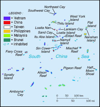
Spratly Islands
Island group · 188,559 km²
Spratly Islands is an island group in Asia (South China Sea), covering an estimated 188,559 km².
The Spratly Islands (Filipino: Kapuluang Spratly; simplified Chinese: 南沙群岛; traditional Chinese: 南沙群島; pinyin: Nánshā Qúndǎo; Malay: Kepulauan Spratly; Vietnamese: Quần đảo Trường Sa) are a disputed archipelago in the South China Sea. Composed of islands, islets, cays, and more than 100 reefs, sometimes grouped in submerged old atolls, the archipelago lies off the coasts of the Philippines, Malaysia, and southern Vietnam. Named after the 19th-century British whaling captain Richard Spratly who sighted Spratly Island in 1843, the islands contain less than 200 ha (500 acres) of naturally occurring land area that is spread over hundreds of square km of the South China Sea.
The Spratly Islands are one of the major archipelagos in the South China Sea which complicate governance and economics in this part of Southeast Asia due to their location in strategic shipping lanes. The islands are largely uninhabited, but offer rich fishing grounds and may contain significant oil and natural gas reserves, and as such are important to the claimants in their attempts to establish international boundaries.
Adapted from Wikipedia: Spratly Islands (CC BY-SA 4.0).
- Feature class
- Island group
- Mapped extent
- 188,559 km²
- Size rank
- #38 of 445 islands
- Region
- Asia
- Subregion
- South China Sea
- Coordinates
- 9.3608°, 114.1246°
- Summits:
- Mount Mantalingajan (2,085 m), Gunung Kinabalu (4,101 m), Bukit Pagon (1,850 m)
- Ranges:
- Dângrêk Range (Asia), Barisan Mountains (Asia)
- Settlements:
- Kota Kinabalu (435 km), Bandar Seri Begawan (506 km), Puerto Princesa (508 km)
More about Spratly Islands
History
The earliest evidence of human presence in the nearby region, dating back nearly 50,000 years, has been found in the Tabon Caves on Palawan in the Philippine islands. By 2,000 BC, the maritime jade road, an advanced and extensive sea-based trade network, was established by the animist indigenous Austronesian peoples of the Philippines and Taiwan. The trade network later expanded to include states in what is now Brunei, Malaysia, Singapore, Thailand, Indonesia, Cambodia, and Vietnam. Between 600 BC to 3 BC there was an east to west migration by members of the seafaring Sa Huỳnh culture, who, like the earlier Austronesians who came before them, may have passed through the Spratly Islands on their way to Vietnam.
Geology
The Spratly Islands consist of islands, reefs, banks and shoals made up of biogenic carbonate. These accumulations of biogenic carbonate lie upon the higher crests of major submarine ridges that are uplifted fault blocks known by geologists as horsts. These horsts are part of a series of half-grabens and rotated fault-blocks which lie parallel and en echelon. The long axes of the horsts, rotated fault blocks and half-grabens form well-defined linear trends that lie parallel to magnetic anomalies exhibited by the oceanic crust of the adjacent South China Sea.
Ecology
In some cays in the Spratly Islands, the sand and pebble sediments form the beaches and spits around the island. Under the influence of the dominant wind direction, which changes seasonally, these sediments move around the island to change the shape and size of the island. For example, Spratly Island is larger during the northeast monsoon (about 700 by 300 metres (2,300 ft × 980 ft)), and smaller during the southwest monsoon (approximately 650 m × 320 m (2,130 ft × 1,050 ft)).
Some islands may contain fresh groundwater fed by rain. Groundwater levels fluctuate during the day with the rhythm of the tides.
Phosphates guano (bird faeces) are mainly concentrated in the beach rocks by the way of exchange-endosmosis.
Geographic and economic overview
In 1939, the Spratly Islands were coral islets mostly inhabited by seabirds. Despite the Spratly Islands naturally consisting of 19 islands (see below), according to a Chinese 1986 source, the Spratly Islands consist of 14 islands or islets, 6 banks, 113 submerged reefs, 35 underwater banks and 21 underwater shoals.
The islands are all of similar nature; they are cays (or keys): sand islands formed on old degraded and submerged coral reefs. The northeast part of the Spratly Islands is known as Dangerous Ground and is characterised by many low islands, sunken reefs, and degraded, sunken atolls with coral often rising abruptly from ocean depths greater than 1,000 m (3,000 ft) — all of which makes the area dangerous for navigation.
Sections adapted from Wikipedia: Spratly Islands (CC BY-SA 4.0).
Spratly Islands: Key Facts
| Surrounded by | West Philippine Sea |
|---|
Facts from Wikidata Q215664 (CC0).
Visiting Spratly Islands
The Spratly Islands are a collection of more than 100 small islands and reefs in the South China Sea, claimed in full or in part by several governments in the region.
Travel notes adapted from Wikivoyage: Spratly Islands (CC BY-SA 4.0).
Mountain Ranges, Deserts and Landforms of Malaysia
2 mountain ranges, deserts and other landforms recorded. Ranked by mapped area. Covers mountain ranges, deserts, plateaus, named glaciers, plains, basins, peninsulas and capes. One that crosses a border is listed under every country it lies in, with the area of the whole feature.
| # | Name | Area | Type | Region |
|---|---|---|---|---|
| 1 | Malay Peninsula | 214,867 km² | Pen/cape | Asia |
| 2 | Datu Peninsula | 557 km² | Pen/cape | Asia |

Malay Peninsula
Pen/cape · 214,867 km²
Malay Peninsula is a pen/cape in Asia, covering an estimated 214,867 km². It extends across Malaysia, Thailand and Myanmar.
The Malay Peninsula is located in Mainland Southeast Asia. The landmass runs approximately north–south, and at its terminus, Tanjung Piai, it is the southernmost point of the Asian continental mainland. The area contains Peninsular Malaysia, Southern Thailand, and the southernmost tip of Myanmar (Kawthaung). The island country of Singapore also has historical and cultural ties with the region.
The Titiwangsa Mountains are part of the Tenasserim Hills system and form the backbone of the peninsula and the southernmost section of the central cordillera, which runs from Tibet through the Kra Isthmus, the peninsula's narrowest point, into the Malay Peninsula. The Strait of Malacca separates the Malay Peninsula from the Indonesian island of Sumatra, and the south coast is separated from the island of Singapore by the Straits of Johor.
Adapted from Wikipedia: Malay Peninsula (CC BY-SA 4.0).
- Feature class
- Pen/cape
- Mapped extent
- 214,867 km²
- Size rank
- #40 of 231 landforms
- Region
- Asia
- Countries
- Malaysia, Thailand, Myanmar
- Coordinates
- 4.4950°, 102.0162°
- Summits:
- Gunung Tahan (2,190 m), Bukit Pagon (1,850 m), Gunung Kinabalu (4,101 m)
- Ranges:
- Barisan Mountains (Asia), Dângrêk Range (Asia)
- Settlements:
- Raub (46 km), Kuala Lumpur (112 km), Teluk Intan (126 km)
More about Malay Peninsula
Ecology
The Malay Peninsula is covered with tropical moist broadleaf forests. Lowland forests are dominated by dipterocarp trees, while montane forests are home to evergreen trees in the beech family (Fagaceae), Myrtle family (Myrtaceae), laurel family (Lauraceae), tropical conifers, and other plant families.
The peninsula's forests are home to thousands of species of animals and plants. Several large endangered mammals inhabit the peninsula – Asian elephant (Elephas maximus), gaur (Bos gaurus), tiger (Panthera tigris), sun bear (Helarctos malayanus), Malayan tapir (Tapirus indicus), clouded leopard (Neofelis nebulosa), and siamang (Symphalangus syndactylus).
Sections adapted from Wikipedia: Malay Peninsula (CC BY-SA 4.0).
Malay Peninsula: Key Facts
| Area | 242,364 km² |
|---|---|
| On | Andaman Sea, Gulf of Thailand |
Facts from Wikidata Q18758 (CC0).
States and Provinces of Malaysia
4 first-level divisions with their own map.
Countries Bordering Malaysia
Land and maritime neighbours.
More Maps in Asia
Malaysia: Quick Answers
- What is the capital of Malaysia?
- The capital of Malaysia is Kuala Lumpur.
- What is the population of Malaysia?
- Malaysia has a population of about 35.98 million, the #45 largest of 225 countries in YearMaps. Source: World Bank, 2025.
- How big is Malaysia?
- Malaysia covers 330,803 km², ranking #70 by area, with about 109 people per square kilometre.
- Which continent is Malaysia in?
- Malaysia is in Asia.
- Which countries border Malaysia?
- Malaysia shares a land or maritime border with Indonesia, Singapore, Thailand, Brunei, Philippines.
- What is the largest city in Malaysia?
- George Town is the largest city in Malaysia, with a metropolitan population of about 2.50 million.
- What is the highest mountain in Malaysia?
- The highest summit recorded for Malaysia in YearMaps is Gunung Kinabalu at 4,101 m (13,455 ft). Summits on a border are counted for both countries.