Skip to content
YearMaps
10 states567 CE – 2024 CE

Medieval States of the Caucasus: Map & History

10 states of the Caucasus on one map, from 567 CE to 2024 CE.The largest, Khazaria, covered about 802,987 km²; the longest-lived, Georgia, lasted 567 CE – 2024 CE. Each has its own section below with its rulers, capitals, wars and pictures where the records hold them.

Evening rooftop view of Savannah, Georgia, U.S., taken near corner of Abercorn St and Bay St., looking northwest
RCraig09 · CC BY-SA 3.0 · Commons
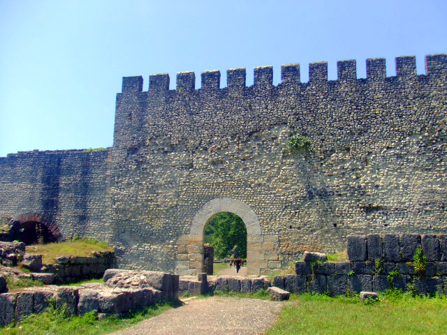
Nokalakevi
Lika (ლიკა) · Public domain · Commons
View of Tbilisi from Tabori Church
Alexey Komarov · CC BY-SA 4.0 · Commons
Charte von Laender am Caucasus nach den besten vorhand Charten, Reisen und Astronomischen Ortsbestimmungen / gegeichnet von I.C.M. Reinecke
Johann Christoph Matthias Reinecke · Public domain · Commons
Base map
567 AD
903 AD
2024 AD
567 AD
900 AD
1100 AD
1400 AD
1700 AD
2024 AD
Epochs:
↗
↗
↗
↗
↗
↗
↗
↗

Each state in its own colour. Move the timeline to see which existed in any year from 567 AD to 2024; select a territory to read about it. Borders: Cliopatria / Seshat (CC BY 4.0).

The Medieval States of the Caucasus Compared

StateYearsCapitalLargest extentRulers
Georgia567 CE – 2024 CE–86,640 km²–
Khazaria630 CE – 979 CEBalanjar (c. 650 – c. 720), Samandar (720–750), Atil (750 – c. 965–969)802,987 km²2
Balasagan638 CE – 646 CEPaytakaran74,449 km²–
Kingdom of Lazica638 CE – 777 CEArchaeopolis23,545 km²2
Principality of Iberia682 CE – 740 CETbilisi34,712 km²2
Kingdom of the Iberians814 CE – 999 CEArtanuji, Bana24,615 km²2
Shirvan825 CE – 1539 CE–113,084 km²–
Bagratid Armenia886 CE – 1045 CEBagaran (885–890), Shirakavan (890–929), Kars (929–961), Ani (961–1045)99,224 km²1
Sajid Dynasty898 CE – 935 CEMaragha, (889–901), Ardabil, (901–929)58,189 km²2
Kingdom of Georgia1010 CE – 1802 CETbilisi197,402 km²5

Timeline of the Medieval States of the Caucasus

When each state existed, 567 CE to 2024 CE. Select a year to see the map then.

  1. Georgia
    567 CE – 2024 CE
  2. Khazaria
    630 CE – 979 CE
  3. Balasagan
    638 CE – 646 CE
  4. Kingdom of Lazica
    638 CE – 777 CE
  5. Principality of Iberia
    682 CE – 740 CE
  6. Kingdom of the Iberians
    814 CE – 999 CE
  7. Shirvan
    825 CE – 1539 CE
  8. Bagratid Armenia
    886 CE – 1045 CE
  9. Sajid Dynasty
    898 CE – 935 CE
  10. Kingdom of Georgia
    1010 CE – 1802 CE

The 10 States

Georgia

567 CE – 2024 CE · 86,640 km²

Evening rooftop view of Savannah, Georgia, U.S., taken near corner of Abercorn St and Bay St., looking northwest
Evening rooftop view of Savannah, Georgia, U.S., taken near corner of Abercorn St and Bay St., looking northwest RCraig09 · CC BY-SA 3.0 · Commons

The Province of Georgia, also known as the Colony of Georgia, was a province of Great Britain in America that existed from 1732 to 1776. It was one of the five Southern colonies and one of the thirteen American colonies. The monarch of Great Britain was represented by the Governor of Georgia, until the American colonies declared independence at Philadelphia on July 4, 1776.

From Wikipedia: Province of Georgia (CC BY-SA 4.0)

Coins, Currency and Symbols

  • Red ensign of Great Britain (1707–1800, square canton)
    Red ensign of Great Britain (1707–1800, square canton) AnonMoos, based on image by Zscout370, AnonMoos · Public domain · Commons
  • Coat of arms of Great Britain (1714–1801)
    Coat of arms of Great Britain (1714–1801) Sodacan · CC BY-SA 3.0 · Commons

Wars and Battles

In the 1742 invasion of Georgia, Spanish forces based in Spanish Florida attempted to seize and occupy disputed territory held by the British colony of Georgia. The campaign was part of a larger conflict which became known as the War of Jenkins' Ear. Local British forces under the command of the Governor James Oglethorpe rallied and defeated the Spaniards at the Battle of Bloody Marsh and the Battle of Gully Hole Creek, forcing them to withdraw. Britain's ownership of Georgia was formally recognized by Spain in the subsequent Treaty of Madrid.

From Wikipedia: Province of Georgia · War of Jenkins' Ear (CC BY-SA 4.0)

Khazaria

630 CE – 979 CE · Capital: Balanjar (c. 650 – c. 720), Samandar (720–750), Atil (750 – c. 965–969) · 802,987 km²

The Khazars (/kəˈzɑːrz/) were a semi-nomadic Turkic people who established a major commercial empire in the late 6th century CE spanning the south of modern European Russia, southern Ukraine, and western Kazakhstan. It was the most powerful polity to emerge from the break-up of the Western Turkic Khaganate.

From Wikipedia: Khazars (CC BY-SA 4.0)

Origins and Founding

An embryonic state of Khazaria began to form sometime after 630, when it emerged from the breakdown of the larger First Turkic Khaganate of the Göktürks. Göktürk armies had penetrated the Volga by 549, ejecting the Avars, who were then forced to flee to the sanctuary of the Pannonian Basin. The Ashina clan appeared on the scene by 552, when they overthrew the Rourans and established the First Turkic Khaganate, whose self designation was Tür(ü)k. By 568, these Göktürks were probing for an alliance with Byzantium to attack the Sasanian Empire. An internecine war broke out between the senior eastern Göktürks and the junior Western Turkic Khaganate some decades later, when on the death of Taspar Qaghan, a succession dispute led to a dynastic crisis between Taspar's chosen heir, the Apa Qaghan, and the ruler appointed by the tribal high council, Āshǐnà Shètú, the Ishbara Qaghan.

From Wikipedia: Khazars · History: Rise of the Khazar state (CC BY-SA 4.0)

Founded
630 CE

Rulers

  • Irbis
  • Bulan

Government, Society and Religion

The earliest surviving Arabic text that refers to Khazar Jewishness appears to be that which was written by Ibn Rustah, a Persian scholar who wrote an encyclopedic work on geography in the early tenth century. It is believed that ibn Rustah derived much of his information from the works of his contemporary Abu al-Jayhani based in Central Asia.

Read more

Christian of Stavelot in his Expositio in Matthaeum Evangelistam (c. 860–870s) refers to Gazari, presumably Khazars, as living in the lands of Gog and Magog, who were circumcised and omnem Judaismum observat—observing all the laws of Judaism. New numismatic evidence of coins dated 837/8 bearing the inscriptions arḍ al-ḫazar "Land of the Khazars", or Mûsâ rasûl Allâh "Moses is the messenger of God", in imitation of the Islamic coin phrase "Muhammad is the messenger of God") suggest to many the conversion took place in that decade.

From Wikipedia: Khazars · Religion: History of discussions about Khazar Jewishness (CC BY-SA 4.0)

Languages
Oghuric (lingua franca), Old Turkic (dynastic, spoken), Alanian (spoken)
Religion
Judaism (official religion of Khazaria since the reign of Khan Bulan), Tengrism, Christianity, Islam, Paganism, Religious syncretism

Economy and Trade

The import and export of foreign wares, and the revenues derived from taxing their transit, was a hallmark of the Khazar economy, although it is said also to have produced isinglass. Distinctively among the nomadic steppe polities, the Khazar Qağanate developed a self-sufficient domestic Saltovo economy, a combination of traditional pastoralism – allowing sheep and cattle to be exported – extensive agriculture, abundant use of the Volga's rich fishing stocks, together with craft manufacture, with diversification in lucrative returns from taxing international trade given its pivotal control of major trade routes.

Read more

The Khazar slave trade constituted one of the two great furnishers of slaves to the Muslim market to slavery in the Abbasid Caliphate (the other being the Iranian Sâmânid amîrs), supplying it with captured Slavs and tribesmen from the Eurasian northlands.

From Wikipedia: Khazars · History: Economy (CC BY-SA 4.0)

Coins, Currency and Symbols

Currency
yarmaq

Wars and Battles

During the 7th and 8th centuries, the Khazars fought a series of wars against the Umayyad Caliphate and its Abbasid successor. The First Arab-Khazar War began during the first phase of Muslim expansion. By 640, Muslim forces had reached Armenia; in 642 they launched their first raid across the Caucasus under Abd ar-Rahman ibn Rabiah. In 652 Arab forces advanced on the Khazar capital, Balanjar, but were defeated, suffering heavy losses; according to Persian historians such as al-Tabari, both sides in the battle used catapults against the opposing troops. A number of Russian sources give the name of a Khazar khagan from this period as Irbis and describe him as a scion of the Göktürk royal house, the Ashina. Whether Irbis ever existed is open to debate, as is whether he can be identified with one of the many Göktürk rulers of the same name.

From Wikipedia: Khazars · History: Arab–Khazar wars (CC BY-SA 4.0)

Achievements and Monuments

The Kuzari is an influential work written by the medieval Spanish Jewish philosopher and poet Rabbi Yehuda Halevi (c. 1075–1141). Divided into five essays (ma'amarim), it takes the form of a fictional dialogue between the pagan king of the Khazars and a Jew who was invited to instruct him in the tenets of the Jewish religion. The intent of the work, although based on Ḥasdai ibn Shaprūṭ's correspondence with the Khazar king, was not historical, but rather to defend Judaism as a revealed religion, written in the context, firstly of Karaite challenges to the Spanish rabbinical intelligentsia, and then against temptations to adapt Aristotelianism and Islamic philosophy to the Jewish faith. Originally written in Arabic, it was translated into Hebrew by Judah ibn Tibbon.

Read more

Benjamin Disraeli's early novel Alroy (1833) draws on Menachem ben Solomon's story.

From Wikipedia: Khazars · In literature (CC BY-SA 4.0)

Decline and Fall

By the 9th century, groups of Varangian Rus', developing a powerful warrior-merchant system, began probing south down the waterways controlled by the Khazars and their protectorate, the Volga Bulgarians, partially in pursuit of the Arab silver that flowed north for hoarding through the Khazarian-Volga Bulgarian trading zones, partially to trade in furs and ironwork. Northern mercantile fleets passing Atil were tithed, as they were at Byzantine Cherson. Their presence may have prompted the formation of a Rus' state by convincing the Slavs, Merja and the Chud' to unite to protect common interests against Khazarian exactions of tribute.

From Wikipedia: Khazars · History: Rise of the Rus' and the collapse of the Khazarian state (CC BY-SA 4.0)

Ended
979 CE

Balasagan

638 CE – 646 CE · Capital: Paytakaran · 74,449 km²

Balāsagān (an Iranian toponym meaning "country of Balas"; Armenian: Bałasakan, the inhabitants known as Bałasičkʻ, Arabic: Balāsajān/Balāšajān), also known as Bazgan, was a region located in the area of the Kura and Aras rivers, adjacent to the Caspian Sea. To the south, it bordered Atropatene/Adurbadagan and Gilan. It roughly corresponded to the Armenian province of Paytakaran, albeit extending farther into the north. It has been suggested that under the Sasanians the region extended as far as the stronghold of Derbent, albeit this remains disputed.

From Wikipedia: Balasagan (CC BY-SA 4.0)

Government, Society and Religion

During the reign of Khosrow II (r. 590–628), the catholicos of Iberia and Albania, Gregory, attempted to convert the people of Balasagan to Christianity. Regardless, pockets of local paganism still remained in the country, notably in Mughan. In c. 800 bishop Eliya, who was sent as a missionary to the area, reports of inhabitants worshipping a god named Yazd, who lived in an oak tree called "king of the forest"; the bushes that encircled the tree were called "children of Yazd." The locals alleged that they had inherited the worship of Yazd from their ancestors. In Middle Persian, the term yazd simply means god, which demonstrates influence from Zoroastrianism, which must have taken place in the Sasanian era.

From Wikipedia: Balasagan · Religion (CC BY-SA 4.0)

Kingdom of Lazica

638 CE – 777 CE · Capital: Archaeopolis · 23,545 km²

Nokalakevi
Nokalakevi Lika (ლიკა) · Public domain · Commons

The Kingdom of Lazica (Georgian: ეგრისი, romanized: Egrisi; Laz: ლაზიკა, romanized: Laziǩa; Ancient Greek: Λαζική, romanized: Lazikḗ), sometimes called Lazian Empire, was a state in the territory of west Georgia in the Roman period, from about the 1st century BC. Created as a result of the collapse of the kingdom of Colchis and the gaining of independence by the tribal-territorial units included in it in 131 AD.

From Wikipedia: Lazica (CC BY-SA 4.0)

Rulers

  • Malassas (first)
  • Tzath II (last)

Government, Society and Religion

Languages
Zan, Old Georgian, Greek (religious)
Religion
Georgian paganism, Eastern Orthodoxy (pre-Schism)

Economy and Trade

Maritime trade played a significant role in the country's economy, with the port of Phasis serving as its main center. Trade was conducted mainly with Pontus and the Bosporan Kingdom in Crimea, which were under Roman control at the time. Leather, fur, and other raw materials, as well as slaves, were exported from Lazica in large quantities. In return, the Laz imported salt, bread, wine, luxury textiles, and weapons. The destruction of free trade and the introduction of a Roman trade monopoly in Lazica are considered among the causes of the Lazic War.

Read more

The primary currency used in Lazica for trade was the Roman Antoninianus until the 4th century. Afterwards it was replaced by the Byzantine Solidus.

From Wikipedia: Lazica · Economy (CC BY-SA 4.0)

Coins, Currency and Symbols

Currency
Antoninianus until IV A.D, later Solidus

Wars and Battles

Principality of Iberia

682 CE – 740 CE · Capital: Tbilisi · 34,712 km²

View of Tbilisi from Tabori Church
View of Tbilisi from Tabori Church Alexey Komarov · CC BY-SA 4.0 · Commons

The Principality of Iberia was an early medieval aristocratic regime in a core Georgian region of Kartli, called Iberia by classical authors. It flourished in the period of interregnum between the sixth and ninth centuries, when the leading political authority was exercised by a succession of princes. The principality was established shortly after the Sassanid suppression of the local royal Chosroid dynasty, around 580; it lasted until 888, when the kingship was restored by a member of the Bagrationi dynasty.

From Wikipedia: Principality of Iberia (CC BY-SA 4.0)

Origins and Founding

Founded
682 CE
Preceded by
Sasanian Iberia

Capitals

Castle of Ardanuç in the Province of Artvin in Turkey.
Castle of Ardanuç in the Province of Artvin in Turkey. Babbsack · CC BY-SA 3.0 · Commons
Tbilisi
Capital
Ardanuç Castle
Capital
Uplistsikhe
Capital

Rulers

  • Guaram I (first)
  • Adarnase IV (last prince)

Government, Society and Religion

Government
feudal monarchy
Languages
Georgian
Religion
Georgian Orthodox Church

Coins, Currency and Symbols

Wars and Battles

Decline and Fall

Ended
740 CE

Kingdom of the Iberians

814 CE – 999 CE · Capital: Artanuji, Bana · 24,615 km²

The Kingdom of the Iberians was a medieval Georgian monarchy under the Bagrationi dynasty which emerged circa 888 AD, succeeding the Principality of Iberia, in historical region of Tao-Klarjeti, or upper Iberia in north-eastern Turkey as well parts of modern southwestern Georgia, that stretched from the Iberian gates in the south and to the Lesser Caucasus in the north. Historically, the area comprised the following historical districts: West of the Arsiani Mountains were Tao, Klarjeti, Nigali, and Shavsheti, to the east lay Meskheti, Erusheti, Javakheti, Artaani, Abotsi, Kola and Basiani.

From Wikipedia: Kingdom of the Iberians (CC BY-SA 4.0)

Origins and Founding

In 813, the last Iberian prince Ashot I of the Bagrationi dynasty established himself in his patrimonial Duchy of Klarjeti, where he restored the castle of Artanuji, said to have been built by the king Vakhtang I of Iberia in the 5th century, and received the Byzantine protection. Being recognized as the presiding prince and curopalates of Iberia, Ashot fought the Arabs from there, gradually incorporating the surrounding lands from the Arab dominance.

Read more

Ashot I encouraged resettlement of Georgians in these lands, and patronized monastic life initiated by the prominent Georgian ecclesiastic figure Gregory of Khandzta (c. 759–861). For a long time the region became a cultural safe-house and one of the most important religious centers of Georgia. As a result, the political and religious center of Iberia was effectively transferred from central Iberia to the south-west, in Tao-Klarjeti.

From Wikipedia: Kingdom of the Iberians · History: Establishment (CC BY-SA 4.0)

Founded
814 CE

Capitals

oltu sülün kaya -köroğlu ormanları
oltu sülün kaya -köroğlu ormanları Halis DURAN · CC BY-SA 3.0 · Commons
Ardanuç
Capital
Ardanuç Castle
Capital

Rulers

  • Ashot I of Iberia
  • Bagrat I

Government, Society and Religion

Government
feudal monarchy
Languages
Georgian
Religion
Eastern Orthodox (Georgian Orthodox Church)

Coins, Currency and Symbols

Wars and Battles

Decline and Fall

Ended
999 CE
Succeeded by
Kingdom of Georgia
Succeeded by
Georgia

Shirvan

825 CE – 1539 CE · 113,084 km²

Charte von Laender am Caucasus nach den besten vorhand Charten, Reisen und Astronomischen Ortsbestimmungen / gegeichnet von I.C.M. Reinecke
Charte von Laender am Caucasus nach den besten vorhand Charten, Reisen und Astronomischen Ortsbestimmungen / gegeichnet von I.C.M. Reinecke Johann Christoph Matthias Reinecke · Public domain · Commons

Shirvan (from Classical Persian شروان Shirwān or شیروان Shīrwān [Iranian Persian: شروان Shervân or شیروان Shirvân]; Azerbaijani: Şirvan; Tat: Şirvan) is a historical Iranian region in the eastern Caucasus, as known both during the pre-Islamic Sasanian Era and the early Islamic period. Today, the region is an industrially and agriculturally developed part of the Republic of Azerbaijan that stretches between the western shores of the Caspian Sea and the Kura River, centered on the Shirvan Plain.

From Wikipedia: Shirvan (CC BY-SA 4.0)

Achievements and Monuments

The term Shirvani/Shirvanli is still in use in Azerbaijan to designate the people of Shirvan region, as it was historically. In ancient times, the bulk of the population of Shirvan were Caucasian-speaking groups. Later on Iranization of this native population and subsequent Turkification since the Seljuq era occurred. The bulk of the population today are Turkic-speaking Azerbaijanis, although there are also smaller Caucasian-speaking and Iranian-speaking minorities.

From Wikipedia: Shirvan · People and culture (CC BY-SA 4.0)

Bagratid Armenia

886 CE – 1045 CE · Capital: Bagaran (885–890), Shirakavan (890–929), Kars (929–961), Ani (961–1045) · 99,224 km²

King Gagik I of Vaspurakan, Аghtamar, facade relief, Armenia, 915–921 (portrait)
King Gagik I of Vaspurakan, Аghtamar, facade relief, Armenia, 915–921 (portrait) Francesco Bini · CC BY-SA 4.0 · Commons

Bagratid Armenia was an independent Armenian state established by Ashot I of the Bagratuni dynasty in the early 880s following nearly two centuries of foreign domination of Greater Armenia under Arab Umayyad and Abbasid rule. With each of the two contemporary powers in the region—the Abbasids and Byzantines—too preoccupied to concentrate their forces on subjugating the region, and with the dissipation of several of the Armenian nakharar noble families, Ashot succeeded in asserting himself as the leading figure of a movement to dislodge the Arabs from Armenia.

From Wikipedia: Bagratid Armenia (CC BY-SA 4.0)

Origins and Founding

The weakening of the Sasanian Empire during the 7th century led to the rise of another regional power, the Muslim Arabs. The Arabs under the Umayyad Caliphate had conquered vast swaths of territory in the Middle East and, turning north, began to periodically launch raids into Armenia territory in 640. Theodore Rshtuni, the Armenian Curopalates, signed a peace treaty with the Caliphate, although the continuing war with the Arabs and Byzantines soon led to further destruction throughout Armenia. In 661, Armenian leaders agreed to submit to Muslim rule while the latter recognized Grigor Mamikonian from the powerful Mamikonian nakharar family as ishkhan (prince) of Armenia. Known as al-Arminiya with its capital at Dvin, the province was headed by an ostikan, or governor.

Read more

However, Umayyad rule in Armenia grew in cruelty in the early 8th century.

From Wikipedia: Bagratid Armenia · History: Background (CC BY-SA 4.0)

Founded
886 CE

Capitals

The medieval Armenian city of Ani now in Turkey as viewed from Armenia.
The medieval Armenian city of Ani now in Turkey as viewed from Armenia. haigoes · CC BY-SA 3.0 · Commons
Shirakavan
Capital
Bagaran
Capital

Rulers

Government, Society and Religion

Most Armenians belonged to the Armenian Apostolic Church, but there were elements in Armenian society who also adhered to the Eastern Orthodox Church, the official religion of the Byzantine Empire. Byzantium repeatedly demanded for communion with the Armenian Church as prerequisite for sending aid to the Bagratunis but most attempts failed to bear any fruit.

Read more

In the mid-10th century, a new internal challenge to the authority of the Armenian Church and the kingdom arose when the Tondrakians experienced a revival. An anti-feudal and heretical Christian sect that had been crushed by the Arabs with the Armenian Church's support in the 9th century, the Tondrakian movement attracted many followers during this period.

From Wikipedia: Bagratid Armenia · Culture and society: Religion (CC BY-SA 4.0)

Government
Monarchy
Languages
Armenian
Religion
Christianity (Armenian Apostolic)

Coins, Currency and Symbols

Currency
Byzantine Hyperpyron, Abbasid Dinar

Wars and Battles

Achievements and Monuments

The Arab raids and invasion of Armenia as well as the devastation wrought upon the land during the Byzantine-Arab wars had largely stifled any expression of Armenian culture in fields such as historiography, literature and architecture. These restrictions disappeared when the Bagratuni kingdom was established, ushering in a new golden age of Armenian culture.

Read more

The lack of a strong Arab presence saw a rise in the number of historians, who wrote and documented the relations between Armenia and other countries and described many events that took place from the seventh to eleventh centuries. Thanks to the patronage of the kings and nobles, monasteries became centers for the study and writing of literature throughout the kingdom. The monasteries of Haghpat and Sanahin were well-known centers for higher learning.

From Wikipedia: Bagratid Armenia · Culture and society: Art and literature (CC BY-SA 4.0)

Decline and Fall

The Byzantines had slowly been creeping eastward towards Armenia in the final decade of the 10th century. Emperor Basil II's numerous victories against the Arabs and internal Arab struggles helped clear a path towards the Caucasus. Constantinople's official policy was that no Christian ruler is equal to or independent of the Byzantine emperor, and even if it was at time masked with diplomatic compromises, the empire's ultimate goal was the complete annexation of the Armenian realms. By the middle of the 10th century, the Byzantine Empire lay along the full length of the western border of Armenia. Taron was the first Armenian region annexed by the Byzantine Empire. In a certain sense, the Byzantines considered the Bagratuni princes of Taron as their vassals, for they had consistently accepted titles, such as that of strategos, and stipends from Constantinople.

From Wikipedia: Bagratid Armenia · History: Decline and Byzantine encroachment (CC BY-SA 4.0)

Ended
1045 CE
Succeeded by
Sasanian Armenia
Succeeded by
Kingdom of Georgia

Sajid Dynasty

898 CE – 935 CE · Capital: Maragha, (889–901), Ardabil, (901–929) · 58,189 km²

The Sajid dynasty (Persian: ساجیان, romanized: sâjiyân, also known as Banu Saj) was a Muslim dynasty, of Iranian origin, that ruled from 889/890 until 929. The Sajids ruled Azerbaijan and parts of Armenia first from Maragha and Barda and then from Ardabil. The Sajids originated from the Central Asian province of Ushrusana and were of Iranian (Sogdian) descent and culturally Arabised. Muhammad ibn Abi'l-Saj Diwdad the son of Diwdad, the first Sajid ruler of Azerbaijan, was appointed as its ruler in 889 or 890.

From Wikipedia: Sajid dynasty (CC BY-SA 4.0)

Rulers

  • Muhammad ibn Abi'l-Saj
  • Abu'l-Musafir al-Fath (last)

Government, Society and Religion

Government
Monarchy
Religion
Sunni Islam

Wars and Battles

Kingdom of Georgia

1010 CE – 1802 CE · Capital: Tbilisi · 197,402 km²

View of Tbilisi from Tabori Church
View of Tbilisi from Tabori Church Alexey Komarov · CC BY-SA 4.0 · Commons

The Kingdom of Georgia, also known as the Georgian Empire, was a medieval Eurasian monarchy that was founded in c. 1008 AD. It reached its Golden Age of political and economic strength during the reign of King David IV and Queen Tamar the Great from the 11th to 13th centuries. Georgia became one of the pre-eminent nations of the Christian East, and its pan-Caucasian empire and network of tributaries stretched from Eastern Europe to Anatolia and northern frontiers of Iran.

From Wikipedia: Kingdom of Georgia (CC BY-SA 4.0)

Origins and Founding

Over the course of the Roman–Persian wars, early Georgian kingdoms were weakened and reduced to feudal regions. As a result of this decline, some parts of the region subsequently fell prey to the early Muslim conquests of the 7th century.

Read more

Iberian princes from the Bagrationi dynasty fought against the Arab occupation and came to rule the Tao-Klarjeti region. They established the Kouropalatate of Iberia as a nominal vassal of the Byzantine Empire. By 888, they had gained control of the central Georgian land, Kartli, and restored the Iberian kingship. The Bagrationi dynasty was unable to maintain their kingdom, and it was divided between the three branches of the family. The main branch controlled Tao, while another controlled Klarjeti.

From Wikipedia: Kingdom of Georgia · Background (CC BY-SA 4.0)

Founded
1010 CE

Rulers

Government, Society and Religion

Bagrat IV's (r.1027 – 1072) coins featured Greek inscriptions alongside Georgian. By the reigns of Demetrius I (r.1125-1154), Giorgi III (r.1156–1184), David IV (r.1089–1125), and Tamar (r.1184 – 1213), coins were minted bearing the titles "malik al-mulūk" and "malikat al-malikāt", respectively. According to Brosset, Georgia used Arabic as a lingua franca because of the importance of trade relations with the Islamic world. Karst supports this stating that the bilingual coins served as an official and visible symbol of the cordial relationship between Georgia and the Caliphate.

Read more

Demetrius I's (r.1125-1154) reign exclusively struck copper coins. There are several recognized patterns in his coinage, which eschewed Byzantine conventions in favor of a hybrid Georgian-Muslim style.

From Wikipedia: Kingdom of Georgia · Government and society: Numismatics (CC BY-SA 4.0)

Government
Feudal monarchy
Languages
Middle Georgian (language of governance, literacy, and coinage), Zan, Greek, Arabic (lingua franca /numismatics/chancery), Persian (numismatics)
Religion
State and majority, Eastern Orthodox (Georgian Orthodox Church), Minority

Coins, Currency and Symbols

Currency
Various Byzantine and Sassanian coins were minted until the 12th century.

Wars and Battles

George I's reign was known primarily for its war against the Byzantines. This war had its roots in the 990s, when David III, after losing a rebellion against the Byzantine Emperor Basil II, agreed to cede his lands in Tao to the emperor upon his death. George I, in an attempt to take back the Kuropalates' land, occupied Tao starting from 1015 or 1016, during a Byzantine war with the Bulgarian Empire. When Bulgaria was dealt with in 1021, Basil II turned his attention to Georgia, leading to a two-year-long war and an eventual Byzantine victory. George, as a result, had to abandon his claims in Tao and surrender some of his southwestern lands, which were eventually made into the theme of Iberia. George's son, who would eventually become Bagrat IV, was also given to Basil as a hostage.

From Wikipedia: Kingdom of Georgia · History: War and peace with Byzantium (CC BY-SA 4.0)

Decline and Fall

Ended
1802 CE
Succeeded by
Kingdom of Kartli
Succeeded by
Kingdom of Kakheti
Succeeded by
Kingdom of Imereti
Succeeded by
Samtskhe atabegate

Medieval States of the Caucasus: Frequently Asked Questions

Which states existed in the Caucasus in this period?

This page maps 10 states of the Caucasus founded between 567 CE and 1010 CE: Georgia, Khazaria, Balasagan, Kingdom of Lazica, Principality of Iberia, Kingdom of the Iberians, Shirvan, Bagratid Armenia, Sajid Dynasty, Kingdom of Georgia.

Which was the largest of the Medieval States of the Caucasus?

Khazaria had the largest mapped extent, about 802,987 km².

Which of the Medieval States of the Caucasus lasted longest?

Georgia lasted longest, 567 CE – 2024 CE.

Sources

  • Reading text: Wikipedia articles on the group and each state, condensed (CC BY-SA 4.0).
  • Facts, rulers and wars: Wikidata (CC0).
  • Borders: Cliopatria, Seshat Global History Databank (CC BY 4.0).
  • Pictures: Wikimedia Commons; the author and licence are under each picture.

Largest state by mapped extent: Khazaria.