Skip to content
YearMaps
15 states705 CE – 2024 CE

Medieval and Early Modern and Modern States of Anatolia and Cyprus: Map & History

15 states of Anatolia and Cyprus on one map, from 705 CE to 2024 CE.The largest, Sultanate of Rum, covered about 367,020 km²; the longest-lived, Republic of Venice, lasted 705 CE – 1796 CE. Each has its own section below with its rulers, capitals, wars and pictures where the records hold them.

Adres wydawniczy: Venezia : Stabilimento Nazionale Di G. Grimaldi, 1867 Współtwórcy: Cicogna, Emmanuele Antonio (1789-1868),Nani, Antonio (1803-1870) Il Opis fizyczny: [170] k. : il. ; 33 cm
Unknown authorUnknown author · Public domain · Commons
City of Van (view from Van Kalesi).
EvgenyGenkin · CC BY-SA 4.0 · Commons
Sivas 20-08-2009
Валерий Дед · CC BY 3.0 · Commons
Ulucami (grand mosque) in Tarsus, Mersin Province
Nedim Ardoğa · CC BY-SA 3.0 · Commons
Base map
705 AD
1307 AD
2024 AD
705 AD
1000 AD
1200 AD
1500 AD
1800 AD
2024 AD
Epochs:
↗
↗
↗
↗
↗
↗
↗
↗

Each state in its own colour. Move the timeline to see which existed in any year from 705 AD to 2024; select a territory to read about it. Borders: Cliopatria / Seshat (CC BY 4.0).

The Medieval and Early Modern and Modern States of Anatolia and Cyprus Compared

StateYearsCapitalLargest extentRulers
Republic of Venice705 CE – 1796 CEVenice65,312 km²40
Kingdom of Vaspurakan911 CE – 1027 CEVan41,810 km²1
Danishmendids1094 CE – 1187 CESivas, Niksar85,805 km²2
Sultanate of Rum1094 CE – 1313 CENicaea (İznik), (1077–1097), Iconium (Konya), (1097–1308), Sebastia (Sivas), (1211–1220)367,020 km²13
Armenian Kingdom of Cilicia1099 CE – 1374 CETarson (Tarsus, Mersin) (1080–1198), Sis (Kozan, Adana) (1198–1375)59,705 km²1
Kingdom of Cyprus1192 CE – 1491 CENicosia12,653 km²17
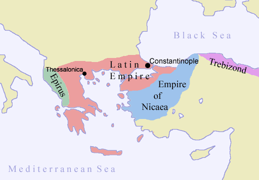
Empire of Trebizond1206 CE – 1462 CETrebizond33,147 km²19
Nicaean Empire1206 CE – 1278 CENicaea (İznik) (de jure), Nymphaion (Kemalpaşa) (de facto)242,675 km²6
Ahi Republic1305 CE – 1362 CE–4,421 km²–
Eshrefids1305 CE – 1325 CEBeyşehir13,289 km²2
Germiyanids1305 CE – 1439 CEKütahya (c. 1300–1381, 1402–1411, 1414–1429), Kula (1381–1399)218,078 km²2
Kastamonu1305 CE – 1343 CE–33,575 km²–
Ramadanid Emirate1385 CE – 1515 CEAdana24,477 km²10
Samtskhe-Saatabago1468 CE – 1506 CEAkhaltsikhe42,721 km²1
Turkish Republic of Northern Cyprus1976 CE – 2024 CENorth Nicosia (de facto), Nicosia (de jure)4,341 km²6

Timeline of the Medieval and Early Modern and Modern States of Anatolia and Cyprus

When each state existed, 705 CE to 2024 CE. Select a year to see the map then.

  1. Republic of Venice
    705 CE – 1796 CE
  2. Kingdom of Vaspurakan
    911 CE – 1027 CE
  3. Danishmendids
    1094 CE – 1187 CE
  4. Sultanate of Rum
    1094 CE – 1313 CE
  5. Armenian Kingdom of Cilicia
    1099 CE – 1374 CE
  6. Kingdom of Cyprus
    1192 CE – 1491 CE
  7. Empire of Trebizond
    1206 CE – 1462 CE
  8. Nicaean Empire
    1206 CE – 1278 CE
  9. Ahi Republic
    1305 CE – 1362 CE
  10. Eshrefids
    1305 CE – 1325 CE
  11. Germiyanids
    1305 CE – 1439 CE
  12. Kastamonu
    1305 CE – 1343 CE
  13. Ramadanid Emirate
    1385 CE – 1515 CE
  14. Samtskhe-Saatabago
    1468 CE – 1506 CE
  15. Turkish Republic of Northern Cyprus
    1976 CE – 2024 CE

The 15 States

Republic of Venice

705 CE – 1796 CE · Capital: Venice · 65,312 km²

Adres wydawniczy: Venezia : Stabilimento Nazionale Di G. Grimaldi, 1867 Współtwórcy: Cicogna, Emmanuele Antonio (1789-1868),Nani, Antonio (1803-1870) Il Opis fizyczny: [170] k. : il. ; 33 cm
Adres wydawniczy: Venezia : Stabilimento Nazionale Di G. Grimaldi, 1867 Współtwórcy: Cicogna, Emmanuele Antonio (1789-1868),Nani, Antonio (1803-1870) Il Opis fizyczny: [170] k. : il. ; 33 cm Unknown authorUnknown author · Public domain · Commons

The Republic of Venice, officially the Most Serene Republic of Venice and traditionally known as La Serenissima, was a maritime republic with its capital in Venice, on the northeastern coast of Italy. Founded, according to tradition, in 697 by Paolo Lucio Anafesto, over the course of its 1,100 years of history it established itself as one of the major European commercial and naval powers.

From Wikipedia: Republic of Venice (CC BY-SA 4.0)

Origins and Founding

Founded
705 CE

Capitals

Malamocco
Malamocco Godromil · Public domain · Commons
Malamocco
742–810 CE

Rulers

Government, Society and Religion

The fundamental administrative subdivision of the Republic of Venice was the regiment, a small territory administered by a podestà, to which a city was headed. The regiments were born only in the first half of the 15th century via the mechanism of dedications. The Republic required the deposition of the lord who was promptly replaced with a rector, after which the city's ambassadors went to Venice where the city's indissoluble bond with the Republic was defined. Because of this mechanism, the Republic of Venice managed to incorporate many territories.

Read more

To govern the most important regiments in an impartial and effective way, the podestà was chosen from among the members of the Venetian patriciate, while in secondary regiments the rector was often chosen from among the local nobility.

From Wikipedia: Republic of Venice · Politics: Administrative subdivisions (CC BY-SA 4.0)

Government
Classical republic under an oligarchy
Languages
Croatian, Chakavian, Greek, Istriot, Friulian, Lombard, Cimbrian, Dalmatian, Albanian, Serbian, Slovene
Religion
Roman Catholicism (state)

Economy and Trade

From its early history, trade was the basis of the Republic of Venice's success and political rise: in 829, the Doge Giustiniano Participazio was involved in the management of his feudal assets and in commercial affairs by sea. The commercial enterprises of Venetian citizens increased in the 12th century, a period which saw the creation of the mude, caravans of merchant galleys which, escorted by armed ships, headed towards the eastern markets, starting with that of Constantinople.

Read more

Venice had a privileged relationship with the Byzantine Empire starting from 1082 when, with the issuing of the Golden Bull, Venetian merchants were allowed to exchange goods with the Byzantines without any tax and to establish an inhabited nucleus directly in the capital, a privilege which however ended violently in 1171 by the decree of Manuel I Komnenos.

From Wikipedia: Republic of Venice · Economy: Trade (CC BY-SA 4.0)

Coins, Currency and Symbols

Lira Tron
Lira Tron CNG · CC BY-SA 2.5 · Commons
Currency
Venetian lira
  • Flag of Republic of Venice (1659-1675)
    Flag of Republic of Venice (1659-1675) Facquis iThe source code of this SVG is invalid due to 268 errors. This W3C-invalid flag was created with Inkscape . · CC BY-SA 4.0 · Commons
  • Coat of arms of Republic of Venice
    Coat of arms of Republic of Venice Facquis · CC BY-SA 4.0 · Commons

Wars and Battles

War with the Ottomans resumed from 1499 to 1503. In 1499, Venice allied itself with Louis XII of France against Milan, gaining Cremona. In the same year, the Ottoman sultan moved to attack Lepanto by land and sent a large fleet to support his offensive by sea. Antonio Grimani, more a businessman and diplomat than a sailor, was defeated in the sea battle of Zonchio in 1499. The Turks once again sacked Friuli. Preferring peace to total war both against the Turks and by sea, Venice surrendered the bases of Lepanto, Durazzo, Modon, and Coron.

Read more

Venice's attention was diverted from its usual maritime position by the delicate situation in Romagna, then one of the richest lands in Italy, which was nominally part of the Papal States, but effectively divided into a series of small lordships which were difficult for Rome's troops to control.

From Wikipedia: Republic of Venice · History: 16th century: League of Cambrai, the loss of Cyprus, and Battle of Lepanto (CC BY-SA 4.0)

Achievements and Monuments

Due to its commercial relationship with the East, the sumptuous clothing typical of the Byzantines soon spread in Venice, consisting mostly of embroidered or quilted blue tunics, the symbolic color of the Venetians. Among the common people, however, long canvas dresses decorated with colored stripes were widespread and the shoes were usually leather sandals. Over the cassock, men often wore large cloaks as well as belts and hats. The clothes of noblewomen were made of embroidered silk, very long and low-cut. They usually also wore trailing cloaks and furs from a large variety of animals, among which the ermine stood out. With the establishment of the guild in the 13th century, the art of tailors was also regulated and protected with the institution of dress tailors, ziponi tailors and sock tailors who dedicated themselves respectively to making clothes, fustian jackets and socks.

From Wikipedia: Republic of Venice · Culture: Fashion (CC BY-SA 4.0)

Decline and Fall

Doge's Palace and facing the lagoon
Doge's Palace and facing the lagoon Didier Descouens · CC BY-SA 4.0 · Commons

By 1796, the Republic of Venice was attempting to negotiate with both Austria and France to avoid conflict knowing they sat between the two major powers and facing internal pressure from the traditionalists of the Venetian system and a growing number of people who were embracing the French values of Revolution. In spring 1796, Piedmont (the Duchy of Savoy) fell to the invading French, and the Austrians were beaten from Montenotte to Lodi. The army under Napoleon crossed the frontiers of neutral Venice in pursuit of the enemy. By the end of the year, the French troops were occupying the Venetian state up to the Adige River. Vicenza, Cadore and Friuli were held by the Austrians. With the campaigns of the next year, Napoleon aimed for the Austrian possessions across the Alps.

From Wikipedia: Republic of Venice · History: Fall (CC BY-SA 4.0)

Ended
1796 CE
Last recorded ruler
Francesco Loredan
Succeeded by
Austrian Empire

Legacy in the Modern World

Though the economic vitality of the Venetian Republic had started to decline since the 16th century with the movement of international trade towards the Atlantic, its political regime still appeared in the 18th century as a model for the philosophers of the Enlightenment.

Read more

Jean-Jacques Rousseau was hired in July 1743 as secretary by Comte de Montaigu, who had been named ambassador of the French in Venice. This short experience, nevertheless, awakened the interest of Rousseau to the policy, which led him to design a large book of political philosophy. After the Discourse on the Origin and Basis of Inequality Among Men (1755), he published The Social Contract (1762).

From Wikipedia: Republic of Venice · History: Legacy (CC BY-SA 4.0)

Kingdom of Vaspurakan

911 CE – 1027 CE · Capital: Van · 41,810 km²

City of Van (view from Van Kalesi).
City of Van (view from Van Kalesi). EvgenyGenkin · CC BY-SA 4.0 · Commons

The Kingdom of Vaspurakan (Armenian: Վասպուրականի թագավորություն; also transliterated as Vasbouragan from Western Armenian) was a medieval Armenian kingdom centered on Lake Van, located in what is now eastern Turkey and northwestern Iran. It was named after Vaspurakan, a province of historic Greater Armenia. Ruled by the Artsruni dynasty, it competed and cooperated with the Bagratuni-ruled Kingdom of Armenia for a little over a century until its last king ceded the kingdom to the Byzantine Empire in 1021.

From Wikipedia: Kingdom of Vaspurakan (CC BY-SA 4.0)

Origins and Founding

Founded
911 CE
Preceded by
Bagratid Armenia

Capitals

Ostan
Capital

Rulers

Government, Society and Religion

Government
Monarchy
Languages
Armenian
Religion
Armenian Apostolic Church

Coins, Currency and Symbols

Currency
Solidus (coin), Hyperpyron

Wars and Battles

Decline and Fall

Ended
1027 CE
Succeeded by
Byzantine Empire

Danishmendids

1094 CE – 1187 CE · Capital: Sivas, Niksar · 85,805 km²

Sivas 20-08-2009
Sivas 20-08-2009 Валерий Дед · CC BY 3.0 · Commons

The Danishmendids or Danishmends (Turkish: Dânişmendliler) were a Turkish dynasty. These terms also refer to the Turkish state in Anatolia. It existed from 1071/1075 to 1178 and is also known as the Danishmendid Beylik (Turkish: Dânişmendliler Beyliği). The dynasty was centered originally around Sivas, Tokat, and Niksar in central-northeastern Anatolia, and extended as far west as Ankara and Kastamonu for a time, and as far south as Malatya, which they captured in 1103.

From Wikipedia: Danishmendids (CC BY-SA 4.0)

Origins and Founding

The Turkoman Chepni Danishmendid dynasty was founded by Danishmend Gazi. Sources about Danishmend Gazi's origins however, are steeped in "legendary flavor". According to Robert Irwin, Danishmend Gazi was a "Turkoman emir of impenetrably obscure origins". For instance, according to Niketas Choniates, a Byzantine government official and historian and a near-contemporary of Danishmend Gazi, he was of Arsacid descent. According to the medieval Armenian historians Matthew of Edessa and Vardan Areveltsi, Danishmend Gazi was of Armenian origin, which, as Tahsin Yazici explains, "is not incompatible with Niketas' report". Yazici adds that other historians explained his origins differently. Some identified him as a nephew of Malik-Shah I (r. 1072–1092), Sultan of the Great Seljuk Empire. According to this narrative, Danishmend Gazi was sent by Malik-Shah to conquer Cappadocia.

From Wikipedia: Danishmendids · Origins (CC BY-SA 4.0)

Founded
1094 CE

Rulers

  • Danishmend Gazi
  • Nasreddin Muhammed

Government, Society and Religion

Government
Monarchy
Languages
Old Anatolian Turkish, Medieval Greek
Religion
Islam

Wars and Battles

Achievements and Monuments

Danishmend Gazi, the founder of the dynasty, is the central figure of a posthumous romance epic, Danishmendnâme, in which he is misidentified with an 8th-century Arab warrior, Sidi Battal Gazi, and their exploits intertwined.

Read more

Virtually all Danishmend rulers entered the traditions of the Turkish folk literature, where they are all referred to as "Melik Gazi". Hence, there are "tombs of Melik Gazi", many of which are much visited shrines and belong in fact to different Danishmend rulers, in the cities of Niksar, Bünyan, Kırşehir, along the River Zamantı near the castle of the same name (Zamantı) and elsewhere in Anatolia, and Melikgazi is also the name of one of the central districts of the city of Kayseri. The same uniformity in appellations in popular parlance may also apply to other edifices built by Danishmends.

From Wikipedia: Danishmendids · Culture and legend (CC BY-SA 4.0)

Sultanate of Rum

1094 CE – 1313 CE · Capital: Nicaea (İznik), (1077–1097), Iconium (Konya), (1097–1308), Sebastia (Sivas), (1211–1220) · 367,020 km²

The Sultanate of Rum, or Seljuk Sultanate of Rum, was a culturally Turco-Persian, Sunni Muslim state established over conquered Byzantine territories and peoples (Rum) of Anatolia by the Seljuk Turks following their entry into Anatolia after the Battle of Manzikert in 1071. The name Rum was a synonym for the medieval Roman Empire and its peoples, as it remains in modern Turkish. The name is derived from the Aramaic (romī) and Parthian (frwm) names for ancient Rome, which had reached these languages via the Greek Ῥωμαῖοι (Romaioi). The Seljuk Turks used the name to refer to Anatolia.

From Wikipedia: Sultanate of Rum (CC BY-SA 4.0)

Origins and Founding

Since the 1030s, migratory Turkish groups in search of pastureland had penetrated Byzantine borders into Anatolia. In the 1070s, after the Battle of Manzikert, the Seljuk commander Suleiman ibn Qutulmish, a distant cousin of Alp Arslan and a former contender for the throne of the Seljuk Empire, came to power in western Anatolia. Between 1075 and 1081, he gained control of the Byzantine cities of Nicaea and briefly also Nicomedia. Around two years later, he established a Sultanate that, while nominally still a Byzantine vassal state, became increasingly independent after six to ten years. The Sultanate was officially recognized as a vassal state by the Seljuk ruler Malikshah in 1084, but as late as 1085, Suleiman was tasked by Byzantine emperor Alexios I Komnenos to reconquer Antioch and the former travelled there on a secret route, presumably guided by the Byzantines.

From Wikipedia: Sultanate of Rum · History: Establishment (CC BY-SA 4.0)

Founded
1094 CE

Capitals

Roman theatre in Nicaea (Iznik).
Roman theatre in Nicaea (Iznik). QuartierLatin1968 · CC BY-SA 3.0 · Commons

Rulers

Government, Society and Religion

The Rum Seljuks sought to establish themselves as orthodox sovereigns dedicated to preserving and defending the structures of Sunni Islam. They sponsored the construction of many madrasas, mosques, and mausolea, expressing their religious devotion through sustained patronage of the ʿulamāʾ and affording them institutional platforms from which to preach to—and potentially convert—the Greek and Armenian Christian communities within their domains.

Read more

In 1084, Suleiman ibn Qutalmish transformed the church of Cassianus in Antioch into a mosque. The construction of the Alâeddin Mosque in Konya, began during sultan Mesud I's reign c. 1116-1156. In 1196, the Friday Mosque of Sivas was constructed during the reigns of Kaykhusraw I and Rukn al-Din Suleiman II. With the capture of Antalya in 1207, Kaykhusraw I established a mosque, while in c.1211 Kaykaus I constructed a madrasa at Ankara.

From Wikipedia: Sultanate of Rum · Religion (CC BY-SA 4.0)

Government
monarchy
Languages
ubl
Religion
Sunni Islam (official), Greek Orthodox (majority of population)

Wars and Battles

Kaykhusraw II (1237–1246) began his reign by capturing the region around Diyarbakır, but in 1239 he had to face an uprising led by a popular preacher named Baba Ishak. After three years, when he had finally quelled the revolt, the Crimean foothold was lost and the state and the sultanate's army had weakened. It is in these conditions that he had to face a far more dangerous threat, that of the expanding Mongols. The forces of the Mongol Empire took Erzurum in 1242 and in 1243, the sultan was crushed by Baiju in the Battle of Köse Dağ (a mountain between the cities of Sivas and Erzincan), resulting in the Seljuk Turks being forced to swear allegiance to the Mongols and became their vassals. The sultan himself had fled to Antalya after the battle, where he died in 1246; his death started a period of tripartite, and then dual, rule that lasted until 1260.

From Wikipedia: Sultanate of Rum · History: Mongol conquest (CC BY-SA 4.0)

Achievements and Monuments

The Sultanate was founded by militaristic bands of Oghuz warriors who Turkified the Anatolian peninsula, and had little in common with the primarily Persian character, language, and culture of the Seljuk rulers. Still, a Turco-Persian cultural synthesis gradually emerged which, by the 13th century, came to define the intellectual and aesthetic life, to the point of Sultanate of Rum elites naming their sons with New Persian names. The phenomenon was reinforced by the massive influx of Persian refugees fleeing the Mongol invasions of the 13th century. The Seljuks of Rum made Turco-Persian tradition the culture of their court, and inherited the tımar and tahrir methods of Persian statecraft from the Seljuk Empire, which they later passed on to the Ottomans. Despites such influences, Seljuk art remained essentially Central Asian in character.

From Wikipedia: Sultanate of Rum · Culture and society (CC BY-SA 4.0)

Decline and Fall

Ended
1313 CE
Last recorded ruler
Kilij Arslan IV
Succeeded by
Beylik of Adana

Armenian Kingdom of Cilicia

1099 CE – 1374 CE · Capital: Tarson (Tarsus, Mersin) (1080–1198), Sis (Kozan, Adana) (1198–1375) · 59,705 km²

Ulucami (grand mosque) in Tarsus, Mersin Province
Ulucami (grand mosque) in Tarsus, Mersin Province Nedim Ardoğa · CC BY-SA 3.0 · Commons

The Armenian Kingdom of Cilicia, also known as Cilician Armenia, Lesser Armenia, Little Armenia or New Armenia, and formerly known as the Armenian Principality of Cilicia, was an Armenian state formed during the High Middle Ages by Armenian refugees fleeing the Seljuk invasion of Armenia. Located outside the Armenian Highlands and distinct from the Kingdom of Armenia of antiquity, it was centered in the Cilicia region, northwest of the Gulf of Alexandretta.

From Wikipedia: Armenian Kingdom of Cilicia (CC BY-SA 4.0)

Origins and Founding

One of the princes who came after Philaretos' invitation was Ruben, who had close ties with the last Bagratid Armenian king, Gagik II. Ruben was alongside the Armenian ruler Gagik when he went to Constantinople upon the Byzantine emperor's request. Instead of negotiating peace, however, the king was forced to cede his Armenian lands and live in exile. Gagik was later assassinated by Greeks. In 1080, soon after this assassination, Ruben organized a band of Armenian troops and revolted against the Byzantine Empire. He was joined by many other Armenian lords and nobles. Thus, in 1080, the foundations of the independent Armenian princedom of Cilicia, and the future kingdom, were laid under Ruben's leadership. His descendants were called Rubenids (or Rubenians).

From Wikipedia: Armenian Kingdom of Cilicia · History: Emergence of Cilician Armenia (CC BY-SA 4.0)

Founded
1099 CE

Capitals

A view from Aşağı Çarşı St. in Kozan, Adana - Turkey.
A view from Aşağı Çarşı St. in Kozan, Adana - Turkey. Zeynel Cebeci · CC BY-SA 4.0 · Commons
Tarsus
Capital
Kozan
Capital

Rulers

Government, Society and Religion

The Catholicosate of the Armenian Apostolic Church followed its people in taking refuge outside the Armenian highlands, which had turned into a battleground of Byzantine and Seljuk contenders. Its seat was first transferred to Sebasteia in 1058 in Cappadocia, where had existed a significant Armenian population. Later, it moved to various locations in Cilicia; Tavbloor in 1062; Dzamendav in 1066; Dzovk in 1116; and Hromkla in 1149. During King Levon I's rule, the Catholicos was located in distant Hromkla. He was assisted by fourteen bishops in administering the Armenian Church in the kingdom, a number which grew in later years. The archbishops' seats were located in Tarsus, Sis, Anazarba, Lambron, and Mamistra. There existed up to sixty monastic houses in Cilicia, although the exact locations of the majority of them remain unclear.

From Wikipedia: Armenian Kingdom of Cilicia · Cilician Armenian society: Religion (CC BY-SA 4.0)

Government
Feudal monarchy
Languages
Armenian (native language), Latin, Old French, Italian, Greek, Syriac
Religion
Christianity (Armenian Apostolic, Armenian Catholic)

Wars and Battles

In the summer of 1299, Het'um I's grandson, King Het'um II, again facing threats of attack by the Mamluks, asked the Mongol khan of Persia, Ghâzân, for his support. In response, Ghâzân marched towards Syria and invited the Franks of Cyprus (the King of Cyprus, the Templars, the Hospitallers, and the Teutonic Knights), to join his attack on the Mamluks. The Mongols took the city of Aleppo, where they were joined by King Het'um. His forces included Templars and Hospitallers from the kingdom of Armenia, who participated in the rest of the offensive. The combined force defeated the Mamluks in the Battle of Wadi al-Khazandar, on December 23, 1299. The bulk of the Mongol army was then obligated to retreat. In their absence, the Mamluks regrouped, and regained the area in May 1300.

From Wikipedia: Armenian Kingdom of Cilicia · History: Campaigns with Mongols (1299–1303) (CC BY-SA 4.0)

Decline and Fall

There had always been close relations between the Armenians and the Lusignans, who, by the 12th century, were already established in the eastern Mediterranean island of Cyprus. Had it not been for their presence in Cyprus, the kingdom of Cilician Armenia may have, out of necessity, established itself on the island. In 1342, Levon's cousin Guy de Lusignan, was anointed king as Constantine II, King of Armenia. Guy de Lusignan and his younger brother John were considered pro-Latin and deeply committed to the supremacy of the Roman Catholic Church in the Levant. As kings, the Lusignans attempted to impose Catholicism and the European ways. The Armenian nobles largely accepted this, but the peasantry opposed the changes, which eventually led to civil strife.

From Wikipedia: Armenian Kingdom of Cilicia · History: Decline and fall with the Lusignan dynasty (CC BY-SA 4.0)

Ended
1374 CE

Kingdom of Cyprus

1192 CE – 1491 CE · Capital: Nicosia · 12,653 km²

Gold Bezant, Hugh I Of Cyprus, 1205-1218
Gold Bezant, Hugh I Of Cyprus, 1205-1218 PHGCOM · CC BY-SA 4.0 · Commons

The Kingdom of Cyprus (French: Royaume de Chypre; Latin: Regnum Cypri) was a medieval kingdom of the Crusader states that existed between 1192 and 1489. Initially ruled as an independent Christian kingdom, it was established by the French House of Lusignan after the Third Crusade. It comprised the island of Cyprus and, on the Anatolia mainland, Antalya between 1361 and 1373, and Corycus between 1361 and 1448.

From Wikipedia: Kingdom of Cyprus (CC BY-SA 4.0)

Rulers

Government, Society and Religion

Like Jerusalem, Cyprus had an Haute Cour (High Court), although it was less powerful than it had been in Jerusalem. The island was richer and more feudal than Jerusalem, so the king had more personal wealth and could afford to ignore the Haute Cour. The most important vassal family was the multi-branch House of Ibelin. However, the king was often in conflict with the Italian merchants, especially because Cyprus had become the centre of European trade with Africa and Asia after the fall of Acre in 1291.

Read more

The kingdom eventually came to be dominated more and more in the 14th century by Genoese merchants, under the leadership of the Republic of Genoa. Cyprus therefore sided with the Avignon Papacy in the Western Schism, in the hope that the French would be able to drive out the Genoese.

From Wikipedia: Kingdom of Cyprus · History: Governance (CC BY-SA 4.0)

Government
Feudal monarchy
Languages
Latin (official/ceremonial), Greek, (native language), Old French (popular), Italian, French, Arabic, Armenian
Religion
Catholic Christianity (State religion), Greek Orthodox Christianity (popular)

Economy and Trade

The economy of Cyprus remained primarily agrarian during the Lusignan period. Simultaneously, though, the island grew in importance in the trade network connecting Western Europe and the Middle East, serving as an entrepôt. This led to an increase in demand on Cypriot products (largely sugar, but also wine, wheat, oil and carobs) abroad, and the agrarian economy became more export-oriented. This allowed Cyprus to become more prosperous relative to the Byzantine period, fuelling the development of the harbour of Famagusta and the capital Nicosia, enabling the construction of architectural works that survive to this day. Whilst the development of these two eclipsed other settlements, towns such as Limassol, Paphos and Kyrenia did take some part in the changing economic environment.

From Wikipedia: Kingdom of Cyprus · Economy (CC BY-SA 4.0)

Coins, Currency and Symbols

Currency
French denier, gros
  • Royal banner of Janus of Cyprus
    Royal banner of Janus of Cyprus Samhanin · CC0 · Commons
  • Coat of Arms of the House of Lusignan (Kings of Armenia, Cyprus and Jerusalem)
    Coat of Arms of the House of Lusignan (Kings of Armenia, Cyprus and Jerusalem) James2813 · CC BY-SA 4.0 · Commons

Wars and Battles

Achievements and Monuments

Cypriot society in the Lusignan period was multi-ethnic, with Orthodox Greek Cypriots making up the majority of the population. Greeks constituted the majority of the population in the rural areas, where they were either serfs (paroikoi) or free tenants (francomati). The population increased until the middle of the fourteenth century, but the Black Death in 1347 and 1348 resulted in the loss of one fifth to one third of the population. Repeated outbreaks prevented population recovery into the fifteenth century. In the 14th century it was common for Cypriot nobility to receive their education in Constantinople.

Read more

Cyprus during this period had a vibrant court culture, in which popular pastimes were practised in a similar fashion to other European Christian societies.

From Wikipedia: Kingdom of Cyprus · Society and culture (CC BY-SA 4.0)

Decline and Fall

Ended
1491 CE
Last recorded ruler
Catherine Cornaro
Succeeded by
Venetian Cyprus

Empire of Trebizond

1206 CE – 1462 CE · Capital: Trebizond · 33,147 km²

Trabzon, harbour
Trabzon, harbour Bertramz · CC BY-SA 3.0 · Commons

The Empire of Trebizond or the Trapezuntine Empire was one of the three Byzantine rump states of the Byzantine Empire that existed during the 13th through to the 15th century. The empire consisted of the Pontus, or far northeastern corner of Anatolia, and portions of southern Crimea. It was formed with the help of Georgia's interventions in Trebizond.

From Wikipedia: Empire of Trebizond (CC BY-SA 4.0)

Origins and Founding

Trebizond already had a long history of autonomous rule before it became the center of a small empire in the Late Middle Ages. Due to its natural harbours, defensible topography and access to silver and copper mines, Trebizond became the pre-eminent Greek colony on the eastern Black Sea shore soon after its founding. Its remoteness from Roman capitals gave local rulers the opportunity to advance their own interest. In the centuries before the founding of the empire the city had been under control of the local Gabras family, which – while officially still remaining part of the Byzantine Empire – minted its own coinage.

Read more

The rulers of Trebizond called themselves Megas Komnenos ("Great Comnenus") and – like their counterparts in the other two Byzantine successor states, the Empire of Nicaea and the Despotate of Epirus – initially claimed supremacy as "Emperor and Autocrat of the Romans".

From Wikipedia: Empire of Trebizond · Origins (CC BY-SA 4.0)

Founded
1206 CE
Preceded by
Byzantine Empire

Rulers

Government, Society and Religion

Government
Monarchy
Languages
Greek
Religion
Greek Orthodoxy, Minority: Georgian Orthodox Church

Economy and Trade

The economy of the Empire of Trebizond (1204–1461) was defined by its strategic position at the southeastern terminus of the historic Silk Road and its control of the southern coast of the Black Sea. Inheriting the commercial infrastructure of the Byzantine province of Chaldia, the empire flourished as a major entrepôt, funneling the wealth of Persia, Armenia, and the broader Asian interior towards Genoese, Venetian, and other Western European markets. While its political power was often confined to a narrow coastal strip, Trebizond’s prosperity was sustained by three pillars: its pivotal role in long-distance transit trade, the export of its own rich natural resources—notably Pontic silver, alum, and agricultural goods like wine and hazelnuts—and its vibrant, autonomous merchant quarters.

From Wikipedia: Empire of Trebizond · Economy (CC BY-SA 4.0)

Wars and Battles

The date Alexios entered Trebizond may be narrowed down even further. Sergey Karpov has identified a lead seal of Alexios, on one side "the image of a strategos in the peaked helmet led by hand by St. George" with the inscriptions Ἀλέξιος ὁ Κομνηνός [Alexios Komnenos] and Ὁ Ἅ(γιος) Γεώργιος [Saint George] on either side; on the obverse is a scene of Ἡ Ἁγία Ἀνάστασις [The Holy Resurrection] with the corresponding inscription. Karpov interprets the significance of this image and the inscription as portraying the most important achievement of his life, St. George inviting the victorious prince to enter Trebizond and opening the gates of the city with his left hand. The importance of St. George was that Easter—the date of the Resurrection—in 1204 fell on 25 April, while the memorial date of St. George was 23 April.

From Wikipedia: Empire of Trebizond · History: Up to the civil wars (CC BY-SA 4.0)

Achievements and Monuments

Christianity strongly influenced society in the Empire of Trebizond. According to the Acts of Vazelon, which were written by contemporary monks, most peasants in the Matzouka region of the Empire had first names relating to Christian religious figures. Last names often referred to Christian saints, trades, and place names.

Read more

In the relatively limited territory of the kingdom of the Grand Komnenoi (known as the "Empire of Trebizond") there was enough room for three dioceses: Trebizond, which was the only diocese established far in the past, Cerasous and Rizaion in Lazika, both formed as upgraded bishoprics. All three dioceses survived the Ottoman conquest (1461) and generally operated until the 17th century, when the dioceses of Cerasous and Rizaion were abolished.

From Wikipedia: Empire of Trebizond · Culture: Religion (CC BY-SA 4.0)

Decline and Fall

This image has been extracted from another file
This image has been extracted from another file various · Public domain · Commons

Following the death of Alexios II, Trebizond suffered a period of repeated imperial depositions and assassinations, despite a short period of stability under his youngest son Basil (1332–1340). Two groups struggled for ascendency: the Scholaroi, who have been identified as being pro-Byzantine, and the Amytzantarantes, who were identified as representing the interests of the native archontes. The years 1347–1348 marked the apex of this lawless period. The Turks took advantage of the weakness of the empire, conquering Oinaion and besieging Trebizond, while the Genoese seized Kerasus. In addition, the Black Death spread from Caffa to ravage Trebizond and other Pontic cities. Bending under the weight of the disasters that accumulated on his states, Emperor Michael abdicated in 1349 in favor of his nephew, Alexios III, who gradually brought the partisans of both factions under control.

From Wikipedia: Empire of Trebizond · History: From the civil wars to the end of the 14th century (CC BY-SA 4.0)

Ended
1462 CE
Succeeded by
Trebizond eyalet
Succeeded by
Ottoman Empire

Nicaean Empire

1206 CE – 1278 CE · Capital: Nicaea (İznik) (de jure), Nymphaion (Kemalpaşa) (de facto) · 242,675 km²

Sepulcre de Constança a sant Joan de l'Hospital
Sepulcre de Constança a sant Joan de l'Hospital Felivet · Public domain · Commons

The Empire of Nicaea (Greek: Βασιλεία Ῥωμαίων), also known as the Nicene Empire, was the largest of the three Greek rump states founded by the aristocracy of the Byzantine Empire that fled when Constantinople was occupied by Western European and Venetian armed forces during the Fourth Crusade, a military event known as the Sack of Constantinople; Latin Empire, was established by an army of Crusaders and Venice after the capture of Constantinople and the surrounding environs.

From Wikipedia: Empire of Nicaea (CC BY-SA 4.0)

Origins and Founding

In 1204, Byzantine emperor Alexios V Doukas Mourtzouphlos fled Constantinople after crusaders invaded the city. Soon after, Theodore I Laskaris, the son-in-law of Emperor Alexios III Angelos, was proclaimed emperor, but he too, realizing the situation in Constantinople was hopeless, fled to the city of Nicaea in Bithynia.

Read more

The Latin Empire, established by the Crusaders in Constantinople, had poor control over former Byzantine territory, and Greek successor states of the Byzantine Empire sprang up in Epirus, Trebizond, and Nicaea. Trebizond had broken away as an independent state a few weeks before the fall of Constantinople. Nicaea, however, was the closest to the Latin Empire and was in the best position to attempt to re-establish the Byzantine Empire.

Theodore Laskaris was not immediately successful, as Henry of Flanders defeated him at Poimanenon and Prusa (now Bursa) in 1204.

From Wikipedia: Empire of Nicaea · History: Foundation (CC BY-SA 4.0)

Founded
1206 CE
Preceded by
Byzantine Empire

Capitals

Panorama of Iznik, taken from the Roman theatre.
Panorama of Iznik, taken from the Roman theatre. QuartierLatin1968 · CC BY-SA 3.0 · Commons
İznik
Capital
Nicaea
Capital

Rulers

Government, Society and Religion

Government
Monarchy
Languages
Byzantine Greek
Religion
Greek Orthodoxy (official)

Wars and Battles

The Nicene Empire consisted of Byzantium's most highly populated Greek region, with the exception of Thrace which was under Latin/Bulgar control. As such, the Empire was able to raise a reasonably numerous military force of around 20,000 soldiers at its height – numbers recorded as participating in its numerous wars against the Crusader states.

Read more

The Nicenes continued some aspects of the Komnenian army, but without the resources available to the Komnenian emperors the Nicene Byzantines could not match the numbers, nor the quality, of the armies that the emperor Manuel I Komnenos and his predecessors had fielded. Western Asia Minor had access to the sea, making it wealthier than most of the splinter states around and in time became the most powerful state in the region, if only for a short period.

From Wikipedia: Empire of Nicaea · Military (CC BY-SA 4.0)

Decline and Fall

Ended
1278 CE
Last recorded ruler
Elena Asenina of Bulgaria
Succeeded by
Byzantine Empire

Ahi Republic

1305 CE – 1362 CE · 4,421 km²

The Ahi Brotherhood (Turkish: Ahî, pl. Ahîler), referred to as Ahi Republic in modern historiography, was a brotherhood union by Ahi Evran in Anatolia (around present-day Ankara) in the 13th and 14th centuries.

From Wikipedia: Ahis (CC BY-SA 4.0)

Origins and Founding

Turkic people began settling in Anatolia in the second half of the 11th century. But they mainly preferred rural areas. Seljuk government on the other hand encouraged those who preferred a settled life in cities. After the Mongols began occupying Khorosan in the early 13th century, people from Khorasan took refuge in Anatolia and the Seljuk government settled some of the newcomers in the cities. So a class of Muslim craftsmen and merchants appeared in the history of Anatolia.

From Wikipedia: Ahis · Background (CC BY-SA 4.0)

Founded
1305 CE

Government, Society and Religion

After the Battle of Kösedağ in 1243, the Seljuks came under the influence of the Ilkhanate Mongols, and during the power vacuum in Anatolia, various tribes or local warlords established their principalities as vassals of Ilkhanids. Ahis in Ankara also saw their chance to declare their semi-independence under Mongol suzerainty towards the end of the century (about 1290). However, Ahi Beylik, unlike the others, was not ruled by a dynasty. It was a religious and commercial fraternity which can be described as a republic not much different from the mercantile republics of the medieval Europe.

From Wikipedia: Ahis · Ahi as a political power (CC BY-SA 4.0)

Eshrefids

1305 CE – 1325 CE · Capital: Beyşehir · 13,289 km²

Taş Köprü ("Stone Bridge") a historical regulator dam in Beyşehir/w:Konya of the modern-day w:Turkey. It was built in the first quarter of 20th century as the first irrigation project of w:Ottoman Empire.
Taş Köprü ("Stone Bridge") a historical regulator dam in Beyşehir/w:Konya of the modern-day w:Turkey. It was built in the first quarter of 20th century as the first irrigation project of w:Ottoman Empire. Noumenon · CC BY-SA 3.0 · Commons

The Eshrefids or Ashrafids (Modern Turkish: Eşrefoğulları or Eşrefoğulları Beyliği) was a 13th-14th century Turkish Anatolian beylik.

From Wikipedia: Eshrefids (CC BY-SA 4.0)

Rulers

  • Suleiman I ibn Eshref Bey
  • Suleiman II Bey

Government, Society and Religion

Government
Emirate
Languages
Turkish
Religion
Sunni Islam

Germiyanids

1305 CE – 1439 CE · Capital: Kütahya (c. 1300–1381, 1402–1411, 1414–1429), Kula (1381–1399) · 218,078 km²

Kütahya Kalesi
Kütahya Kalesi Omerserez · CC BY-SA 4.0 · Commons

Germiyan, or the Germiyanids (Old Anatolian Turkish: كرميان; Turkish: Germiyanoğulları Beyliği or Germiyan Beyliği), were a dynasty that controlled parts of western Anatolia from c. 1300 to 1429. Germiyan first appeared in the 12th-century chronicles of Matthew of Edessa and The Georgian Chronicles when they fought against the County of Edessa and the Kingdom of Georgia. They reappeared in historical records of 1239 near Malatya, where they were tasked with suppressing the Babai revolt. The tribe relocated to western Anatolia with the encroaching Mongol invasion.

From Wikipedia: Germiyanids (CC BY-SA 4.0)

Origins and Founding

During the 11th century, much of West Asia was subject to Seljuk rule. A branch of the Seljuk dynasty formed the Sultanate of Rum, an Islamic state in Anatolia, which saw its height from the late 12th century to 1237. Germiyan likely came from Kerman or Fars province, and perhaps headed west with the Khwarazmshahs. After the death of Jalal al-Din Mangburni, they remained in the Malatya area.

Read more

Germiyan is first mentioned in the 1162 chronicle of the Armenian author Matthew of Edessa in regards to a battle near Azaz in 1119 under the Turkoman lord Ilghazi against the Crusader Joscelin I, Count of Edessa (r. 1118–31). Matthew locates the Germiyan north of the Artuqids near Malatya, indicating their location wasn't "immediately obvious" to his audience.

From Wikipedia: Germiyanids · History: Background (CC BY-SA 4.0)

Founded
1305 CE

Rulers

  • Yakub I
  • Mehmed

Government, Society and Religion

Government
Monarchy
Languages
Old Anatolian Turkish
Religion
Islam

Wars and Battles

Achievements and Monuments

Yakub's architectural legacy included the Yakub Chelebi Külliye (building complex) in Kütahya. It was built in 1411–12 and is composed of an imaret, masjid, türbe (tomb), madrasa (school), and library. After five months of operation, the Karamanid occupation forced the imaret to close for two and a half years. In 1414, when the region was regained by the Ottoman Sultan Mehmed I on behalf of Yakub, the building returned to use, and inscriptions (vakfiye), 2 by 3.70 meters in size, were added to the building, detailing its history. The inscriptions indicate that the imaret was owned by Mehmed I. It was later destroyed and the building was restored in accordance with its original form by its waqf (endowment) trustee Ishak Fakih bin Halil in 1440–41. In 1803, the Ottoman governor of Anatolia, Gurju Osman Pasha, commissioned its reparation and merged the imaret and the masjid.

From Wikipedia: Germiyanids · Culture: Architecture (CC BY-SA 4.0)

Kastamonu

1305 CE – 1343 CE · 33,575 km²

Kaleden Cumhuriyet Meydanı ve Çevresi
Kaleden Cumhuriyet Meydanı ve Çevresi Barış37 · CC BY-SA 3.0 · Commons

Kastamonu (greek: Κασταμονή)is a city in northern Turkey. It is the seat of Kastamonu Province and Kastamonu District. Its population is 125,622 (2021). The city lies at an elevation of 904 m (2,966 ft). It is located in the southern part of the province.

From Wikipedia: Kastamonu (CC BY-SA 4.0)

Achievements and Monuments

Kastamonu is home to Kastamonu University, which was established in 2006 by incorporating existing colleges, schools, and institutes that were previously under Ankara University and Gazi University. Notable high schools in Kastamonu are: Abdurrahman Paşa Lisesi, also known as Kastamonu Lisesi, the first modern high school that was established in Anatolia in late Ottoman Empire. Kastamonu Mustafa Kaya Lisesi, an Anatolian high school, one of the most successful high schools in Turkey outside Istanbul, Ankara and İzmir.

From Wikipedia: Kastamonu · Education (CC BY-SA 4.0)

Ramadanid Emirate

1385 CE – 1515 CE · Capital: Adana · 24,477 km²

Adana City and Seyhan Lake
Adana City and Seyhan Lake Anatolianpride · Public domain · Commons

The Ramadanid Emirate (Modern Turkish: Ramazanoğulları Beyliği) was a Turkish autonomous administration and a de facto independent emirate that existed from 1352 to 1608 in Cilicia, taking over the rule of the region from the Armenian Kingdom of Cilicia. The emirate was a protectorate of the Mamluk Sultanate until the end of the 14th century, then it was de facto independent for more than a century, and then, from 1517, a protectorate of the Ottoman Empire. The capital was Adana. The Ramadanid Emirate was the only emirate in Anatolia that was not a successor of the Anatolian Seljuk Sultanate.

From Wikipedia: Ramadanid Emirate (CC BY-SA 4.0)

Origins and Founding

Founded
1385 CE
Preceded by
Sultanate of Rum

Rulers

Government, Society and Religion

Government
Emirate
Languages
Turkish, Armenian, Arabic, Syriac
Religion
Bektashi, Christianity (Armenian Apostolic Church, Syriac Christianity), Islam

Coins, Currency and Symbols

  • Yuregir
    Yuregir Unknown author · Public domain · Commons

Wars and Battles

Decline and Fall

Ended
1515 CE
Last recorded ruler
Selim Bey
Succeeded by
Adana eyalet

Samtskhe-Saatabago

1468 CE – 1506 CE · Capital: Akhaltsikhe · 42,721 km²

Portrait Beka I Jaqeli
Portrait Beka I Jaqeli 14th century CE · Public domain · Commons

The Samtskhe-Saatabago or Samtskhe Atabegate (Georgian: სამცხე-საათაბაგო), also called the Principality of Samtskhe (სამცხის სამთავრო), was a Georgian feudal principality in Zemo Kartli, ruled by an atabeg (tutor) of Georgia for nearly three and a half centuries, between 1268 and 1625. Its territory consisted of the modern-day Samtskhe-Javakheti region and the historical region of Tao-Klarjeti.

From Wikipedia: Samtskhe-Saatabago (CC BY-SA 4.0)

Origins and Founding

By the Ilkhan request, David Ulu's army was dispatched to defend the fortifications of Siba against the Golden Horde in 1263. In 1265, the Georgian forces serving as a vanguard of the Ilkhanid army, defeated Berke, Khan of the Golden Horde, and expelled his troops from Shirvan. Sargis Jaqeli distinguished himself in battle against the Horde, even saving Hulagu's life, for which Hulagu offered him rich rewards, including the city of Erzurum. David Ulu subsequently persuaded Hulegu to revoke that award on the basis that it would make Sargis too powerful. As a result of a dispute with the royal court, the province of Samtskhe seceded and submitted directly to the Ilkhan rule in 1266. Thus, Georgia further disintegrated to form three separate political entities.

From Wikipedia: Samtskhe-Saatabago · History: Establishment of the Princedom (CC BY-SA 4.0)

Founded
1468 CE

Rulers

Government, Society and Religion

Government
Principality
Languages
Georgian
Religion
Eastern Orthodox Christianity

Coins, Currency and Symbols

  • Flag of the Principality of Samtskhe
    Flag of the Principality of Samtskhe Ercwlff · CC BY-SA 4.0 · Commons
  • Coat of arms of Principality of Samtskhe
    Coat of arms of Principality of Samtskhe Samhanin · Public domain · Commons

Wars and Battles

Decline and Fall

Ended
1506 CE
Succeeded by
Gurjistan Eyalet

Turkish Republic of Northern Cyprus

1976 CE – 2024 CE · Capital: North Nicosia (de facto), Nicosia (de jure) · 4,341 km²

Yakın Doğu Üniversitesi Hukuk Fakültesi.
Yakın Doğu Üniversitesi Hukuk Fakültesi. Orhanozkilic · CC BY-SA 3.0 · Commons

Northern Cyprus, officially the Turkish Republic of Northern Cyprus (TRNC), is a de facto state comprising the northern third of the island of Cyprus. It is recognised only by Turkey, with the international community considering it territory of the Republic of Cyprus under Turkish military occupation. It extends from Cape Apostolos Andreas (the tip of the Karpass Peninsula) in the northeast to Morphou Bay in the northwest, with Cape Kormakitis at its westernmost point and the Kokkina exclave west of the mainland.

From Wikipedia: Northern Cyprus (CC BY-SA 4.0)

Origins and Founding

Founded
1976 CE

Rulers

Government, Society and Religion

No country other than the Republic of Turkey has officially recognised Northern Cyprus as a sovereign state. The United Nations considers it a territory of the Republic of Cyprus under Turkish occupation. Pakistan and Bangladesh reportedly planned to recognize Northern Cyprus as a sovereign state shortly after its declaration of independence, but were persuaded to withhold recognition under the threat that they would risk losing US foreign aid. The United Nations considers the declaration of independence by Northern Cyprus as legally invalid, as enunciated in several of its resolutions.

Read more

In the wake of the April 2004 referendum on the United Nations Annan Plan, and in view of the support of the Turkish Cypriot community for the plan, the European Union made pledges towards ending the isolation of Northern Cyprus. These included measures for trade and €259 million in aid.

From Wikipedia: Northern Cyprus · Government and politics: International status and foreign relations (CC BY-SA 4.0)

Government
Unitary semi-presidential republic
Languages
Cypriot Turkish

Economy and Trade

The economy of Northern Cyprus is dominated by the services sector (69% of GDP in 2007) which includes the public sector, trade, tourism and education. The revenues gained by the education sector in 2011 was $400 million. Industry (light manufacturing) contributes 22% of GDP and agriculture 9%. The economy of Northern Cyprus is based on a free market approach and it became the top country in Europe in entrepreneurial intent to start a new business in 2014.

Read more

Economic development is adversely affected by the continuing Cyprus problem. Northern Cyprus is under an international embargo as the Republic of Cyprus, as the internationally recognised authority, has declared airports and ports in the area not under its effective control closed. All UN member states other than Turkey respect the closure of those ports and airports.

From Wikipedia: Northern Cyprus · Economy (CC BY-SA 4.0)

Coins, Currency and Symbols

1 Lira coin
1 Lira coin Sa-se · Public domain · Commons
Currency
Turkish lira
  • Format of Turkish Lira Symbol
    Format of Turkish Lira Symbol TCMB · CC BY-SA 3.0 · Commons
  • Flag of the Turkish Republic of Northern Cyprus
    Flag of the Turkish Republic of Northern Cyprus See File History, below for details. · Public domain · Commons
  • Coat of arms of the Turkish Republic of Northern Cyprus
    Coat of arms of the Turkish Republic of Northern Cyprus derivative work: Pbroks13 (talk) New-TRNC-coa.GIF: Expatkiwi The original uploader was Expatkiwi at English Wikipedia. · CC BY-SA 3.0 · Commons

Achievements and Monuments

Poetry is the most widely published form of literature in Northern Cyprus. Turkish Cypriot poetry is based on both the effects of Turkish literature and the culture of the island of Cyprus, along with some reflection of the British colonial history.

Read more

The first era of Turkish Cypriot poetry after the introduction of the Latin alphabet, characterised by poets such as Nazif Süleyman Ebeoğlu, Urkiye Mine Balman, Engin Gönül, Necla Salih Suphi and Pembe Marmara, had strong nationalistic elements due to the political attitudes of Turkish Cypriots at the time and stylistically reflected the poetry of the Turkish mainland. Meanwhile, other poets, such as Özker Yaşın, Osman Türkay, who was nominated for the Nobel Prize in Literature twice, and Nevzat Yalçın sought to write in more original styles, with the influence of nascent poetic styles in Turkey and those in Britain.

From Wikipedia: Northern Cyprus · Culture: Literature (CC BY-SA 4.0)

Decline and Fall

Ended
2024 CE
Last recorded ruler
Tufan Erhürman

Medieval and Early Modern and Modern States of Anatolia and Cyprus: Frequently Asked Questions

Which states existed in Anatolia and Cyprus in this period?

This page maps 15 states of Anatolia and Cyprus founded between 705 CE and 1976 CE: Republic of Venice, Kingdom of Vaspurakan, Danishmendids, Sultanate of Rum, Armenian Kingdom of Cilicia, Kingdom of Cyprus, Empire of Trebizond, Nicaean Empire, Ahi Republic, Eshrefids, Germiyanids, Kastamonu and 3 more.

Which was the largest of the Medieval and Early Modern and Modern States of Anatolia and Cyprus?

Sultanate of Rum had the largest mapped extent, about 367,020 km².

Which of the Medieval and Early Modern and Modern States of Anatolia and Cyprus lasted longest?

Republic of Venice lasted longest, 705 CE – 1796 CE.

Sources

  • Reading text: Wikipedia articles on the group and each state, condensed (CC BY-SA 4.0).
  • Facts, rulers and wars: Wikidata (CC0).
  • Borders: Cliopatria, Seshat Global History Databank (CC BY 4.0).
  • Pictures: Wikimedia Commons; the author and licence are under each picture.

Largest state by mapped extent: Sultanate of Rum.