Ancient States of the Indian Subcontinent: Map & History
25 states of the Indian Subcontinent on one map, from 3000 BCE to 1138 CE.The largest, White Huns, covered about 3,300,430 km²; the longest-lived, Anurādhapura, lasted 291 BCE – 1017 CE. Each has its own section below with its rulers, capitals, wars and pictures where the records hold them.
Each state in its own colour. Move the timeline to see which existed in any year from 3000 BC to 1138 AD; select a territory to read about it. Borders: Cliopatria / Seshat (CC BY 4.0).
The Ancient States of the Indian Subcontinent Compared
Replica of 'Dancing Girl' of Mohenjo-daro at Chhatrapati Shivaji Maharaj Vastu Sangrahalaya in Mumbai, India.Photograph: Joe Ravi · CC BY-SA 3.0 · Commons
The Indus Valley Civilisation (IVC), also known as the Indus Civilisation, was a Bronze Age civilisation in the northwestern regions of South Asia, lasting from 3300 BCE to 1300 BCE, and in its mature form from 2600 BCE to 1900 BCE. Together with ancient Egypt, Mesopotamia, and China, it was one of the four centres of the ancient world; it was geographically larger than ancient Egypt and Mesopotamia combined. It spanned much of Pakistan, northwestern India, and northeast Afghanistan.
Archaeological records provide no immediate answers for the question of who ruled Harappan cities and how. Nonetheless, there are indications of complex decisions being taken and large-scale mobilisation of resources. For instance, the majority of the cities were constructed in a highly uniform and well-planned grid pattern, divided into two levels from ground making one part slightly higher than the other; such complex urban planning, combined with the construction of large public works projects, demonstrates the existence of some sort of planning authority. The remarkable consistency of Harappan weights and measures, as evident in pottery, seals, weights and bricks, also indicates the existence of a central authority able to make definitive regulations.
Read more
There was a single state or federation ruling all or most of the Indus Valley.
The Indus Valley Civilisation may have had bullock carts identical to those seen throughout South Asia today, as well as boats. Most of these boats were probably small, flat-bottomed craft, perhaps driven by sail, similar to those one can see on the Indus River today. An extensive canal network, used for irrigation, has however also been discovered by H.-P. Francfort.
Read more
During 4300–3200 BCE of the chalcolithic period (copper age), the Indus Valley Civilisation area shows ceramic similarities with southern Turkmenistan and northern Iran which suggest considerable mobility and trade. During the Early Harappan period (about 3200–2600 BCE), similarities in pottery, seals, figurines, ornaments, etc. document intensive caravan trade with Central Asia and the Iranian plateau.
500 BCE – 405 BCE · Capital: Rajagriha, later Pataliputra · 335,215 km²
The Haryanka dynasty (Sanskrit: हर्यंक; IAST: Haryaṅka) was the ruling dynasty of Magadha, according to the Buddhist text Mahavamsa between 544 BC and 413 BC though some scholars favour a later chronology (5th century BCE to first half of 4th century BCE). Initially, the capital was Rajagriha. Later, it was shifted to Pataliputra, near present-day Patna in India during the reign of Udayin. Bimbisara is considered to be the founder of the dynasty.
According to the Mahavamsa, Bimbisara was appointed king by his father, Bhattiya, at the age of fifteen.
The governance structure of Haryanka dynasty is mentioned in ancient texts. They mention gramakas (village headmen) who headed village assemblies and mahamatras (high-ranking officials) who had executive, judicial and military functions.
Read more
Historically, this period coincided with the Achaemenid conquest of the Indus Valley during the rule of Darius I from about 517/516 BCE.
According to the Mahavamsa, Haryanka dynasty was overthrown by their Amatya (minister), Shishunaga who then established Shaishunaga Dynasty. However, Jain texts mention that Udayin was killed by an assassin of rival kingdom. Being childless, he was succeeded by Nanda who was selected by his ministers.
404 BCE – 334 BCE · Capital: Rajgir (primary), Vaishali (secondary), later Pataliputra · 797,305 km²
Vishwa Shanti Stupa (World Peace Pagoda) on Vulture Peak, Rajgir, Bihar, Indiamyself (Knverma (talk)) · CC BY-SA 3.0 · Commons
The Shaishunaga dynasty (IAST: Śaiśunāga, literally "of Shishunaga") was possibly the second ruling dynasty of Magadha. According to the Buddhist text Mahavamsa, this dynasty was the second ruling dynasty of Magadha, succeeding Nagadashaka of the Haryanka dynasty. The Hindu Puranas have given a different list with different chronology of the Shaishunaga dynasty kings, whereas Jain texts do not mention this dynasty.
I12 1karshapana Maghada 1ar (8482307176)Jean-Michel Moullec from Vern sur Seiche (35, Bretagne), France · CC BY 2.0 · Commons
The Nanda Empire was a vast empire that governed in Magadha and Gangetic plains with an enormous geographical reach in 4th-century BCE northeastern India, with some accounts suggesting existence as far back as the 5th century BCE. The Nandas built on the successes of their Haryanka and Shaishunaga predecessors and installed a more centralised administration. Ancient sources credit them with amassing great wealth, which was probably the result of the introduction of a new currency and taxation system.
Both Indian and Greco-Roman traditions characterise the dynasty's founder as of low birth. According to Greek historian Diodorus (1st century BCE), Porus told Alexander that the contemporary Nanda king was thought to be the son of a barber. Roman historian Quintus Curtius Rufus (1st century CE) adds that according to Porus, this barber became the former queen's paramour thanks to his attractive looks, treacherously assassinated the then king, usurped the supreme authority by pretending to act as a guardian for the then princess, and later killed the princess.
Read more
The Jain tradition, as recorded in the Avashyaka Sutra and the 12th century text Parishishtaparvan, corroborates the Greco-Roman accounts, stating that the first Nanda king was the son of a barber. According to the 12th-century text Parishishtaparvan, the mother of the first Nanda king was a courtesan.
Little information survives on the Nanda administration today. The Puranas describe the Nanda king as ekarat ("single ruler"), which suggests that the Nanda empire was an integrated monarchy rather than a group of virtually independent feudal states. However, the Greek accounts suggest the presence of a more federated system of governance. For example, Arrian mentions that the land beyond the Beas River was governed by "the aristocracy, who exercised their authority with justice and moderation." The Greek accounts mention the Gangaridai and the Prasii separately, although suggesting that these two were ruled by a common sovereign. Historian H. C. Raychaudhuri theorises that the Nandas held centralised control over their core territories in present-day Bihar and Uttar Pradesh, but allowed considerable autonomy in the frontier parts of their empire.
Alexander the Great invaded northwestern India at the time of Agrammes or Xandrames, whom modern historians generally identify as the last Nanda king – Dhana Nanda. In the summer of 326 BCE, Alexander's army reached the Beas River (Greek: Hyphasis), beyond which the Nanda territory was located.
Read more
The Greek sources suggest that the Nanda army was five times the size of the Macedonian army. According to Curtius, Alexander learned that Agrammes had 200,000 infantry; 20,000 cavalry; 3,000 elephants; and 2,000 four-horse chariots. Diodorus gives the number of elephants as 4,000. Plutarch inflates these numbers significantly, except the infantry: according to him, the Nanda force included 200,000 infantry; 80,000 cavalry; 6,000 elephants; and 8,000 chariots.
A granite stone fragment of an arch discovered by K. P. Jayaswal from Kumhrar, Pataliputra has been analysed as a pre Maurya-Nanda period keystone fragment of a trefoil arch of gateway with mason's marks of three archaic Brahmi letters inscribed on it which probably decorated a Torana. The wedge-shaped stone with indentation has Mauryan polish on two sides and was suspended vertically.
Based upon the "extreme points of Kalinga."Throws of went · CC0 · Commons
Kalinga (Sanskrit: [kɐliŋɡɐ]) is a historical region of India. It is generally defined as the eastern coastal region between the Ganges and the Godavari rivers, although its boundaries have fluctuated with the territory of its rulers. The core territory of Kalinga now encompasses all of Odisha and some part of northern Andhra Pradesh. At its widest extent, the Kalinga region also included parts of present-day Chhattisgarh, extending up to Amarkantak in the west. In the ancient period it extended until the bank of the Ganges river.
After the final battle near the Dhauli hills, the capital Tosali fell to the Mauryas where the headquarters of the Mauryan province of Kalinga was also located.
Read more
Kalinga broke away from the Mauryan empire during the rule of Dasharatha in 224 BCE.
The merchant Kaundinya I, who became the co-founder of the Funan kingdom (centered in modern Cambodia) after he married the local Nāga princess Soma also has his origins from the ancient Kalinga region.
Read more
According to scholar R. C. Majumdar, the 8th century CE Shailendra dynasty of Java likely originated from Kalinga and the dynasty was also powerful in Cambodia and Champa(Annam) region. The Shailendras are considered to have been a thalassocracy and ruled vast swathes of maritime Southeast Asia and the dynasty appeared to be the ruling family of both the Mataram kingdom of Central Java, for some period and the Srivijaya kingdom in Sumatra.
Anuradhapura (Sinhala: අනුරාධපුරය, romanised: Anurādhapuraya, IPA: [ənuraːd̪əpurəjə]; Tamil: அனுராதபுரம், romanised: Aṉurātapuram, IPA: [ɐnuɾaːðɐβuɾɐm]) is a major city located in the north central plain of Sri Lanka. It is the capital city of North Central Province and the capital of Anuradhapura District. The city lies 205 kilometres (127 mi) north of the current capital of Colombo in the North Central Province, on the banks of the historic Malwathu Oya. The city is now a World Heritage Site famous for its well-preserved ruins of the ancient Sinhalese civilisation.
The city's prominence declined following invasions by South Indian dynasties, notably the Chola conquest in 993 CE. Although the political centre shifted to Polonnaruwa, Anuradhapura remained a vital religious site, continuing to attract Buddhist pilgrims.
Anuradhapura became the centre of administration of the North Central Province and with the building of the Northern Railway line, Anuradhapura became an important railway town with the opening of the Anuradhapura railway station in 1904. The Government of Ceylon tasked Oliver Weerasinghe to develop the Anuradhapura Preservation Plan in 1949, aimed at establishing a new planned town east of the existing Anuradhapura town, thereby establishing the Sacred city of Anuradhapura, with the aim of preserving the ancient city. The "New Town" had many of the government offices and law courts moved into it. The Anuradhapura Preservation Board was established with this aim.
Read more
Nissanka Wijeyeratne was Government Agent of Anuradhapura District from 1958 to 1962.
The Chera dynasty (or Cēra, IPA: [t͡ʃeːɾɐ]), also known as Keralaputra, Kedalaputho, from the early historic or the Sangam period in southern India, ruled over parts of present-day states Kerala and Tamil Nadu. The Cheras, known as one of the mu-ventar (the Three Crowned Kings) of Tamilakam (the Tamil country) alongside the Cholas and Pandyas, have been documented as early as the third century BCE. The Chera country was geographically well placed at the tip of the Indian peninsula to profit from maritime trade via the extensive Indian Ocean networks.
The events described in the early Tamil texts, or the Sangam Literature, are dated to around the first or second centuries CE based on the Gajabahu-Chenguttuvan synchronism, which is derived from certain verses in the Tamil epic poem Silappathikaram. Despite its reliance on a number of conjectures, this method is considered a sheet anchor for dating early historic south India. Complementary archaeological (and epigraphical) evidence broadly seems to support the Gajabahu chronology.
Read more
Ilango Adigal, the author of Silappathikaram, describes the renowned Chera ruler Chenguttuvan, a central figure in the epic, as his elder brother. He also mentions Chenguttuvan's consecration of a temple for the goddess Pattini (Kannaki) at Vanchi (the Chera capital on the Malabar Coast).
Trading relations with merchants from Graeco-Roman world, or the Yavanas, and with northern India provided considerable economic momentum for southern India; the main economic activity was trade across the Indian Ocean. The earliest Graeco-Roman accounts referring to the Cheras are by Pliny the Elder in the first century, in the first-century text Periplus Maris Erythraei, and by Claudius Ptolemy in the second century. The Periplus Maris Erythraei portrays the trade in the territory of Cheras or "Keprobotras" in detail. The port of Muziris, or Muchiri in Tamil, located in the Chera country, was the most-important centre in the Malabar Coast, which according to the Periplus "abounded with large ships of Romans, Arabs and Greeks". Bulk spices, ivory, timber, pearls and gems were exported from Chera country, and southern India, to the Middle East/Mediterranean regions.
The early Tamil texts, or Sangam literature, reflect a society with unique cultural traditions. The surviving Sangam poems often celebrate themes of war and love. The Puram poems praise the valor and generosity of rulers, while the Akam poems express human emotions through associations with specific geographical landscapes.
Read more
In general, the literature reflect the southern Indian cultural tradition and some elements of the northern Indian cultural tradition, which by then was coming into contact with the south. Most of the Chera population, like the rest of the Tamil country, probably followed native Dravidian belief systems. Notable was the belief in Ananku, the sacred forces inhabiting various objects, including humans. It was controlled through the performance of specific rites and rituals.
After about the fifth century, the influence of the Cheras appears to have declined significantly compared to the early historic period. Comparatively little is known about the Cheras during this time. The Cheras ruling at Vanchi-Karur (present-day Karur) in the Kongu country (western Tamil Nadu), also called the "Keralas", seems to have dominated the former Chera territories, including present-day Kerala, in this period.
Read more
The region subsequently experienced the rise of the Kalabhras, followed by Chalukya or Pallava-Pandya domination, and later the ascendancy of the Rashtrakutas and the Cholas. By around the ninth century CE, central Kerala appears to have separated from the larger "Chera/Kerala kingdom" to form the "medieval Chera kingdom of Kerala" (Mahodayapuram).
The Early Pandyas of the Sangam period were one of the three main kingdoms of the Tamils, the other two being the Cholas, and Cheras dynasty. As with many other kingdoms around this period (earlier than 200 BCE), most of the information about the Early Pandyas come to modern historians mainly through literary sources and some epigraphic, archaeological and numismatic evidence. The capital of the Early Pandyan kingdom was initially Korkai, Thoothukudi and was later moved to Koodal (now Madurai) during the reign of Nedunjeliyan I.
The origin of the word "Pandya" has been a subject of much speculation.
Read more
Historians have used several sources to identify the origins of the Early Pandyan dynasty with the pre-Christian Era and also to piece together the names of the Pandyan kings. Unfortunately, the exact genealogy of these kings has not been authoritatively established yet.
One theory is that the word Pandya is derived from the Tamil word "Pandi" meaning bull. Ancient Tamils, considered the bull as a sign of masculinity and valor. Pandya became the epithet of the first Pandyan king of Thenmadurai (lit. south Mathurai), Kulasekharan Pandya as he was built like a bull. It was used as an epithet of masculinity. His son, the second king of Thenmadurai, the legendary Malayadhwaja Pandya who sided with the Pandavas and took part in the Kurukshetra battle is described as follows in Karna Parva (verse 20.25).
The head of the government was the king, a hereditary monarch. His power was restricted by the Aimberunguzhu (Tamil: ஐம்பெருங்குழு) or the Five Great Assemblies, which consisted of the representatives of the people, priests, physicians, astrologers and the ministers. There was another assembly of officials that served the king called the Enberaayam (Tamil: எண்பேராயம்) or the Eight Groups of Attendants. While some scholars believe it consisted of attendants on the king's person like the perfumers, dressing valets, etc., others believe it consisted of more important persons like the people of the capital city, the leaders of the elephant corps and of the cavalry. The principal officers of State were the high priest, the chief astrologer, the ministers and the commanders of the army.
225 BCE – 223 CE · Capital: Pratishthana, Amaravati, Pauni, Junnar · 890,254 km²
Bimbisara with his royal cortege issuing from the city of Rajagriha to visit the Buddha, Sanchi, East Face - South Pillar - East GatewayBiswarup Ganguly · CC BY 3.0 · Commons
The Satavahanas (Sādavāhana or Sātavāhana, IAST: Sātavāhana), also referred to as the Andhras (also Andhra-bhṛtyas or Andhra-jatiyas) in the Puranas, were an ancient Indian dynasty. Most modern scholars believe that the Satavahana rule began in the late 2nd century BCE and lasted until the early 3rd century CE, although some assign the beginning of their rule to as early as the 3rd century BCE based on the Puranas, but uncorroborated by archaeological evidence. The Satavahana kingdom mainly comprised the present-day Andhra Pradesh, Telangana, and Maharashtra.
The use of the names "Andhra" and "Andhra-Jatiya" in the Puranas has led some scholars, such as E. J. Rapson and R.G Bhandarkar, to believe that the dynasty originated in the eastern Deccan region (the historic Andhra region, present-day Andhra Pradesh and Telangana). At Kotilingala in Telangana, coins bearing the legend "Rano Siri Chimuka Satavahanasa" were found. Epigraphist and numismatist P. V. P. Sastry initially identified Chimuka with the dynasty's founder Simuka, Coins attributed to Simuka's successors Kanha and Satakarni I were also discovered at Kotilingala. Based on these discoveries, historians such as Ajay Mitra Shastri, D. R. Reddy, S. Reddy, and Shankar R. Goyal theorised that Kotlingala was the original home of the Satavahanas.
The royal princes (kumaras) were appointed as viceroys of the provinces.
Read more
The ahara appears to have been the largest geographical subdivision of the Satavahana polity. Several inscriptions refer to aharas named after the governors appointed to rule them (e.g. Govardhanahara, Mamalahara, Satavanihara and Kapurahara). This suggests that the Satavahanas attempted to build a formal administrative and revenue collection structure.
The inscriptions of Gautamiputra Satakarni suggest the existence of a bureaucratic structure, although it is not certain how stable and effective this structure was. For example, two inscriptions from Nashik Cave 11 record donations of agricultural land to ascetic communities. They state that the ascetics would enjoy tax exemption and non-interference from the royal officials.
The Satavahanas were the earliest Indian rulers to issue their own coins with portraits of their rulers, starting with king Gautamiputra Satakarni, a practice derived from that of the Western Kshatrapas he defeated. The Western Satraps themselves had been following the features of the coins of the Indo-Greek kings to the northwest.
Read more
Thousands of lead, copper and potin Satavahana coins have been discovered in the Deccan region; a few gold and silver coins are also available. These coins do not feature uniform design or size, and suggest that multiple minting locations existed within the Satavahana territory, leading to regional differences in coinage.
The coin legends of the Satavahanas, in all areas and all periods, used a Prakrit dialect without exception.
The Satavahana paintings are the earliest surviving specimens—excluding prehistoric rock art—in India, and they are to be found only at the Ajanta Caves. There were two phases of artistic activity of Ajanta: the first occurring in the 2nd to 1st centuries BCE, when Hinayana caves were excavated during Satavahana rule; the later in the second half of the 5th century under the Vakatakas. Vagaries of nature and some vandalism have taken a heavy toll on the Ajanta Caves. Only a few fragments related to the Satavahanas have survived in Caves No. 9 and 10, both of which are chaitya-grihas with stupas.
Read more
The most important surviving painting of the Satavahana period at Ajanta is the Chhadanta Jataka in Cave No. 10, but that, too, is only fragmentary. It is a painting of an elephant named Bodhisattva with six tusks, related to a mythological story.
After Yajna Satakarni, the dynasty was soon extinguished following the rise of its feudatories, perhaps on account of a decline in central power. On the other hand, the Western Satraps would continue to prosper for the next two centuries, until their extinction by the Gupta Empire. Yajna Sri was succeeded by Madhariputra Swami Isvarasena. The next king Vijaya ruled for 6 years. His son Vasishthiputra Sri Chadha Satakarni ruled for 10 years. Pulumavi IV, the last king of the main line, ruled until c. 225 CE. During his reign, several Buddhist monuments were constructed at sites including Nagarjunakonda and Amaravati. Madhya Pradesh was also part of his kingdom.
The Mahameghavahana dynasty (IAST: Mahā-Mēgha-Vāhana) 2nd or 1st century BC to early 4th century CE) was an ancient ruling dynasty of Kalinga after the decline of the Maurya Empire. In the first century B.C. conquered Kalinga and Kosala. During the reign of Kharavela, the third king of Mahameghavahana dynasty, South Kosala became an integral part of the kingdom. He patronised Jainism, but did not discriminate against other religions. He is known by his Hathigumpha inscription.
The inscription mentions the regular collection and remission of taxes by the government. The inscription also mentions the King's restorative and building activities, building of a canal, a victory palace and an amphitheatre. Agriculture was flourishing in the state.
Read more
The inscription mentions the king's possession of a vast army of cavalry, infantry, elephantry and chariots.
Ardhamagadhi Prakrit (official, court procedural, and inscriptional), Sanskrit (Literature)
Religion
Jainism (official), Ajivikism, Buddhism, Hinduism
Achievements and Monuments
Udayagiri and Khandagiri Caves is the most prominent example of Mahameghavahana dynasty work. These caves were built in 2nd century BCE during the rule of King Kharavela. Udayagiri means "Sunrise Hill" and has 18 caves while Khandagiri (means "Broken Hill") has 15 caves. The Hathigumpha cave ("Elephant Cave") has the Hathigumpha inscription, written by Raja Kharavela, the king of Kalinga in India, during the 2nd century BCE. The Hathigumpha inscription consists of seventeen lines incised in deep cut Brahmi letters starting with Jain Namokar Mantra. In Udayagiri, Hathigumpha (cave 14) and Ganeshagumpha (cave 10) are especially well known due to art treasures of their sculptures and reliefs as well as due to their historical importance. Rani ka Naur (Queen's Palace cave, cave 1) is also an extensively carved cave and elaborately embellished with sculptural friezes.
Bharhut Sunga individualLeiden University Library / Royal Netherlands Institute of Southeast Asian and Caribbean Studies · Public domain · Commons
The Shunga Empire (IAST: Śuṅga) was a ruling entity centred around Magadha and controlled most of the northern Indian subcontinent from around 187 to 75 BCE. The dynasty was established by Pushyamitra, after taking the throne of Magadha from the Mauryas. The Shunga empire's capital was Pataliputra, but later emperors such as Bhagabhadra also held court at Besnagar (modern Vidisha) in eastern Malwa. This dynasty is also responsible for successfully fighting and resisting the Greeks in Shunga–Greek War.
Pushyamitra ruled for 36 years and was succeeded by his son Agnimitra.
According to historical reconstructions, the Shunga dynasty was established in 184 BCE, about 50 years after Ashoka's death, when the emperor Brihadratha Maurya, the last ruler of the Maurya Empire, was assassinated by his Senānī or commander-in-chief, Pushyamitra, while he was reviewing the Guard of Honour of his forces. Pushyamitra then ascended the throne.
Read more
Pushyamitra became the ruler of Magadha and neighbouring territories. His realm essentially covered the central parts of the old Mauryan Empire. The Shunga definitely had control of the central city of Ayodhya in northern central India, as is proved by the Dhanadeva-Ayodhya inscription. However, the city of Mathura further west never seems to have been under the direct control of the Shungas, as no archaeological evidence of a Shunga presence has ever been found in Mathura.
The Greeks seem to have maintained control of Mathura. The Yavanarajya inscription, also called the "Maghera inscription", discovered in Mathura, suggests that the Indo-Greeks were in control of Mathura during the 1st century BCE. The inscription is important in that it mentions the date of its dedication as "The last day of year 116 of Yavana hegemony (Yavanarajya)". It is considered that this inscription is attesting the control of the Indo-Greeks in the 2nd and 1st centuries BCE in Mathura, a fact that is also confirmed by numismatic and literary evidence. Moreover, it does not seem that the Shungas ever ruled in Mathura or Surasena since no Shunga coins or inscriptions have been found there.
Read more
The Anushasana Parva of the Mahabharata affirms that the city of Mathura was under the joint control of the Yavanas and the Kambojas.
The Shunga art style differed somewhat from imperial Mauryan art, which was influenced by Persian art. In both, continuing elements of folk art and cults of the Mother goddess appear in popular art, but are now produced with more skill in more monumental forms. The Shunga style was thus seen as 'more Indian' and is often described as the more indigenous.
Read more
Art, education, philosophy, and other learning flowered during this period. Most notably, Patanjali's Yoga Sutras and Mahabhashya were composed in this period. It is also noted for its subsequent mention in the Malavikaagnimitra. This work was composed by Kalidasa in the later Gupta period, and romanticised the love of Malavika and King Agnimitra, with a background of court intrigue.
Later Shunga emperors were seen as amenable to Buddhism and as having contributed to the building of the stupa at Bharhut. During his reign the Buddhist monuments of Bharhut and Sanchi were renovated and further improved. There is enough evidence to show that Pushyamitra patronised Buddhist art. However, given the rather decentralised and fragmentary nature of the Shunga state, with many cities actually issuing their own coinage, as well as the relative dislike of the Shungas for the Buddhist religion, some authors argue that the constructions of that period in Sanchi for example cannot really be called "Shunga". They were not the result of royal sponsorship, in contrast with what happened during the Mauryas, and most of the dedications at Sanchi were private or collective, rather than the result of royal patronage.
The Indo-Scythians, also known as Indo-Sakas, were a group of nomadic people of Iranic Scythian origin who migrated from Central Asia southward into the present-day regions of Afghanistan, eastern Iran and the northwestern Indian subcontinent (present-day Pakistan and northern India). The migrations persisted from the middle of the second century BCE to the fourth century CE.
The first Saka king in the Indian subcontinent was Maues (first century BCE) who established Saka power in Gandhara, the Indus Valley, and other regions.
The ancestors of the Indo-Scythians are generally believed to have been Saka (Scythian) (Kamuia) Kamboja tribes.
Read more
One group of Indo-European speakers that makes an early appearance on the Xinjiang stage is the Saka (Ch. Sai). Saka is more a generic term than a name for a specific state or ethnic group; Saka tribes were part of a cultural continuum of early nomads across Siberia and the Central Eurasian steppe lands from Xinjiang to the Black Sea. Like the Scythians whom Herodotus describes in book four of his History (Saka is an Iranian word equivalent to the Greek Scythes, and many scholars refer to them together as Saka-Scythian), Sakas were Iranian-speaking horse nomads who deployed chariots in battle, sacrificed horses, and buried their dead in barrows or mound tombs called kurgans.
Indo-Scythian coinage is generally of high quality, although the coins of Rajuvula deteriorate near the disintegration of Indo-Scythian rule c. 20 CE. A fairly high-quality, stereotypical coinage was continued by the Western Satraps until the fourth century.
Read more
Indo-Scythian coinage is generally realistic, artistically between Indo-Greek and Kushan coinage. It has been suggested that its coinage benefited from the help of Greek coin-makers.
Indo-Scythian coins continue Indo-Greek tradition by using the Greek alphabet on the obverse and Kharoshthi script on the reverse. A portrait of the king is absent, with depictions of the king on a horse (sometimes on a camel) or sitting cross-legged on a cushion instead. The reverse of their coins typically show Greek gods.
Buddhist symbolism is present in Indo-Scythian coinage.
After Azes' death, Indo-Scythian rule in northwestern India ended with the rise of the Indo-Parthian ruler Gondophares late in the first century BCE. For the following decades, A number of minor Scythian leaders maintained themselves in local strongholds on the fringes of the loose Indo-Parthian empire over the next few decades, some paying allegiance to Gondophares I and his successors.
Read more
Indo-Parthian rule was gradually replaced with that of the Kushans, one of the five Yuezhi tribes who lived in Bactria for over a century and expanded into India during the late first century CE. The Kushans regained northwestern India c. 75 CE and the Mathura region c. 100, where they prospered for several centuries.
The Indo-Scythians were named "Shaka" in India, a variation of the name "Saka" used by the Persians for Scythians. Shakas are mentioned in the Purāṇas, the Manusmṛti, the Rāmāyaṇa, the Mahābhārata, the Mahābhāṣya, the Bṛhat Saṃhitā by Varāhamihira, the Kāvyamīmāṃsā, the Bṛhatkathāmañjarīi, and the Kathāsaritsāgara. They are described as part of a group of other warlike tribes from the northwest.
Read more
There are references to the warring mleccha hordes of Sakas, Yavanas, Kambojas and Pahlavas in the Balakanda of the Ramayana. H. C. Raychadhury saw in these verses the struggles between the Hindus and the invading hordes of mleccha barbarians from the northwest beginning in the second century BCE, and fixed the date of the Ramayana around (or after) the 2nd century CE.
Tadeusz Sulimirski notes that the Saka invaded parts of northern India. Indian linguist Weer Rajendra Rishi has identified linguistic affinities between Indian and Central Asian languages, which also suggests a Saka influence in northern India.
126 BCE – 13 CE · Capital: Taxila, Sagala · 784,828 km²
Circular medallion, Begram, Room 13, 1st century A.D., Plaster 22,3 cm, National Museum of Afghanistan, Personal photograph 2011, British Museum.Artacoana · CC BY-SA 3.0 · Commons
The Indo-Greek Kingdom, also known as the Yavana Kingdom, were Hellenistic-era Greek kingdoms in the northwestern part of the Indian subcontinent covering most of modern-day Pakistan, parts of northwestern India and some eastern parts of Afghanistan.
The term "Indo-Greek Kingdom" loosely describes a number of various Hellenistic states, ruling from regional capitals like Taxila, Sagala, Pushkalavati, and Bagram.
In India, the Maurya dynasty was overthrown around 185 BC when Pushyamitra Shunga, the commander-in-chief of Mauryan Imperial forces and a Brahmin, assassinated the last of the Mauryan emperors Brihadratha. Pushyamitra Shunga then ascended the throne and established the Shunga Empire, which extended its control as far west as the Punjab.
Read more
"At this time [after the rule of Chandragupta, Bindusara and Ashoka] the best of the brahmanas, Kanyakubja, performed sacrifice on the top of a mountain named Arbuda. By the influence of Vedic mantras, four Kshatriyas appeared from the yajna (sacrifice). (...) They kept Ashoka under their control and annihilated all the Buddhists. It is said there were 4 million Buddhists and all of them were killed by uncommon weapons".
Chandragupta Maurya, the founder of the Mauryan Empire, conquered the Greek satraps left by Alexander, which belonged to Seleucus I Nicator of the Seleucid Empire. The Mauryan Emperor Ashoka would then establish the largest empire in the Indian Subcontinent through an aggressive expansion. Ashoka converted to Buddhism following the destructive Kalinga War, abandoning further conquests in favor of humanitarian reforms. Ashoka erected the Edicts of Ashoka to spread Buddhism and the 'Law of Piety' throughout his dominion. In one of his edicts, Ashoka claims to have converted his Greek population along with others to Buddhism.
Read more
Here in the king's domain among the Greeks, the Kambojas, the Nabhakas, the Nabhapamkits, the Bhojas, the Pitinikas, the Andhras and the Palidas, everywhere people are following Beloved-of-the-Gods' instructions in Dharma.
Greco-Buddhism (Ruling dynasty), Other religions, Ancient Greek religion, Buddhism, Hinduism, Jainism, Zoroastrianism
Economy and Trade
After the death of Demetrius, the Bactrian kings Pantaleon and Agathocles struck the first bilingual coins with Indian inscriptions found as far east as Taxila so in their time (c. 185–170 BC) the Bactrian kingdom seems to have included Gandhara. These first bilingual coins used the Brahmi script, whereas later kings would generally use Kharoshthi. They also went as far as incorporating Indian deities, variously interpreted as Hindu deities or the Buddha. They also included various Indian devices (lion, elephant, zebu bull) and symbols, some of them Buddhist such as the tree-in-railing. These symbols can also be seen in the Post-Mauryan coinage of Gandhara.
Read more
The Hinduist coinage of Agathocles is few but spectacular. Six Indian-standard silver drachmas were discovered at Ai-Khanoum in 1970, which depict Hindu deities.
The armed forces of the Indo-Greeks engaged in battles with other Indian kingdoms. The ruler of Kalinga, King Kharavela, states in the Hathigumpha inscription that during the 8th year of his reign he led a large army in the direction of a Yavana King, and that he forced their demoralized army to retreat to Mathura."Then in the eighth year, (Kharavela) with a large army having sacked Goradhagiri causes pressure on Rajagaha (Rajagriha). On account of the loud report of this act of valour, the Yavana (Greek) King Dimi[ta] retreated to Mathura having extricated his demoralized army."
Read more
The name of the Yavana king is not clear, but it contains three letters, and the middle letter can be read as ma or mi. R. D. Banerji and K.P. Jayaswal read the name of the Yavana king as "Dimita", and identify him with Demetrius I of Bactria.
In general, the art of the Indo-Greeks is poorly documented, and few works of art (apart from their coins and a few stone palettes) are directly attributed to them. The coinage of the Indo-Greeks however is generally considered some of the most artistically brilliant of Antiquity. The Hellenistic heritage (Ai-Khanoum) and artistic proficiency of the Indo-Greek world would suggest a rich sculptural tradition as well, but traditionally very few sculptural remains have been attributed to them. On the contrary, most Gandharan Hellenistic works of art are usually attributed to the direct successors of the Indo-Greeks in India in the 1st century AD, such as the nomadic Indo-Scythians, the Indo-Parthians and, in an already decadent state, the Kushans In general, Gandharan sculpture cannot be dated exactly, leaving the exact chronology open to interpretation.
From the mid-2nd century BC, the Scythians, in turn being pushed forward by the Yuezhi who were completing a long migration from the border of China, started to invade Bactria from the north. Around 130 BC the last Greco-Bactrian king Heliocles was probably killed during the invasion and the Greco-Bactrian kingdom proper ceased to exist. The Parthians also probably played a role in the downfall of the Bactrian kingdom.
Read more
Immediately after the fall of Bactria, the bronze coins of Indo-Greek king Zoilos I (130–120 BC), successor of Menander in the western part of the Indian territories, combined the club of Herakles with a Scythian-type bowcase and short recurve bow inside a victory wreath, illustrating interaction with horse-mounted people originating from the steppes, possibly either the Scythians (future Indo-Scythians), or the Yuezhi (future Kushans) who had invaded Greco-Bactria.
From the 1st century AD, the Greek communities of central Asia and the northwestern Indian subcontinent lived under the control of the Kushan branch of the Yuezhi, apart from a short-lived invasion of the Indo-Parthian Kingdom. The Kushans founded the Kushan Empire, which was to prosper for several centuries. In the south, the Greeks were under the rule of the Western Kshatrapas. The Kalash tribe of the Chitral Valley claim to be descendants of the Indo-Greeks; although this is disputed.
Read more
It is unclear how much longer the Greeks managed to maintain a distinct presence in the Indian sub-continent. The legacy of the Indo-Greeks was felt however for several centuries, from the usage of the Greek language and calendrical methods, to the influences on the numismatics of the Indian subcontinent, traceable down to the period of the Gupta Empire in the 4th century.
66 BCE – 28 BCE · Capital: Pataliputra and Besnagara · 1,155,441 km²
The Kanva dynasty or Kanvavamsha was a ruling dynasty of Magadha, established after Vasudeva Kanva overthrew the preceding Shunga dynasty and ruled from 73 BCE to 28 BCE.
Although the Puranic literature indicates that the Kanvas ruled from the former capital of the Shungas in Pataliputra, Magadha in Eastern India, their coins are primarily found in and around the region of Vidisha in Central India, which had also been the capital of later Shunga rulers.
The Kanva dynasty was established by Vasudeva Kanva in 73 BCE.
The Indo-Parthian kingdom, also known as Pahlavas in the ancient Sanskrit texts, was a syncretic state founded by Gondophares I in the first century CE. At its zenith, Gondophares ruled an area which today covers parts of eastern Iran, parts of Afghanistan, most of Pakistan and parts of northwestern India. Indo-Parthians continued to rule in some areas until 226 CE, with Paratarajas continuing until late 3rd century.
The kingdom was founded in 19/20 when the governor of Drangiana (Sakastan) Gondophares I declared independence from the Parthian Empire.
The religion of the House of Suren is unknown although it is known to have been in conflict with the Zoroastrian Arsacid dynasty. Unlike the Indo-Greeks or Indo-Scythians, there are no explicit records of Indo-Parthian rulers supporting Buddhism, such as religious dedications, inscriptions or even legendary accounts. Also, although Indo-Parthian coins generally closely follow Greek numismatics, they never display the Buddhist triratna symbol (apart from the later Sases), and they never use depictions of the elephant or the bull, possible religious symbols that were profusely used by their predecessors. They are thought to have retained Zoroastrianism since they were of Iranian extraction themselves. This Iranian mythological system was inherited from them by the later Kushans who ruled from Peshawar in Gandhara.
43 CE – 237 CE · Capital: 1st Century BCE: Kapisa/Pushkalavati;, from 1st century CE: Purushapura/Mathura, 3rd and 4th centuries CE: Taxila · 2,267,303 km²
Bagram, Afghanistan. This is a photograph of the bazaar in Bagram city.JE at English Wikipedia · CC BY 3.0 · Commons
The Kushan Empire (c. 30–c. 375 CE) was a syncretic empire formed by the Yuezhi in the early 1st century CE. Initially based in the Bactrian territories, it spread to encompass much of what is now Afghanistan, India, Pakistan, Tajikistan, Turkmenistan and Uzbekistan. Kushan territory in India extended at least as far as Saketa and Sarnath near Varanasi, where inscriptions have been found dating to the era of the Kushan emperor Kanishka the Great.
Chinese sources describe the Guìshuāng (貴霜, Old Chinese: *kuj-s raŋ), i.e. the Kushans, as one of the five aristocratic tribes of the Yuezhi. Many scholars believe that the Yuezhi were a people of Indo-European origin. A number of scholars have suggested a specifically Tocharian origin of the Yuezhi. An Iranic Saka origin has also been suggested by some scholars.
Read more
The Yuezhi were described in the Records of the Great Historian and the Book of Han as living in the grasslands of eastern Xinjiang and northwestern part of Gansu, in the northwest of modern-day China, until their King was beheaded by the Xiongnu (匈奴) who were also at war with China, which eventually forced them to migrate west in 176–160 BC. The five tribes constituting the Yuezhi are known in Chinese history as Xiūmì (休密), Guìshuāng (貴霜), Shuāngmǐ (雙靡), Xìdùn (肸頓), and Dūmì (都密).
The Kushans inherited the Greco-Buddhist traditions of the Indo-Greek Kingdom they replaced, and their patronage of Buddhist institutions allowed them to grow as a commercial power. Between the mid-1st century and the mid-3rd century, Buddhism, patronised by the Kushans, extended to China and other Asian countries through the Silk Road. Kanishka in particular is well-known in Buddhist tradition for having convened a great Buddhist council in Kashmir.
Read more
During the 1st century AD, Buddhist books were being produced and carried by monks, and their trader patrons. Also, monasteries were being established along these land routes that went from China and other parts of Asia. With the development of Buddhist books, it caused a new written language called Gandhara. Gandhara consists of eastern Afghanistan and northern Pakistan.
Greek (official until)), discarded Greek (Ionian) as the language of administration and adopted Bactrian ("Arya language")., Bactrian (official from), Gandhari Prakrit, Hybrid Sanskrit
Religion
Hinduism, Buddhism, Zoroastrianism
Coins, Currency and Symbols
Coin of Kushan empire, King Vasudeva IIanonymous · CC0 · Commons
Currency
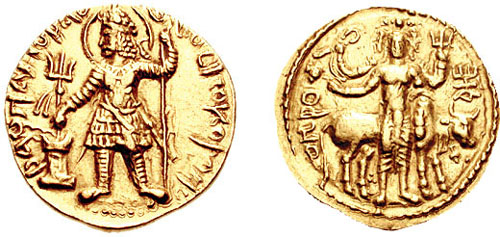
Kushan coinage
Coin: Havishka (reverse) title QS:P1476,en:"Coin: Havishka (reverse) "label QS:Len,"Coin: Havishka (reverse) "label QS:Lfr,"pièce d'or de l'empire Kushan du roi Havishka"anonymous · CC0 · Commons
Coin of Kushan empire, King Vasudeva Ianonymous · CC0 · Commons
Coin of Kushan King Vima Kadphisesanonymous · CC0 · Commons
The Kushans adopted elements of the Hellenistic culture of Bactria. They adopted the Greek alphabet to suit their own language (with the additional development of the letter Þ "sh", as in "Kushan") and soon began minting coinage on the Greek model. On their coins they used Greek language legends combined with Pali legends (in the Kharosthi script), until the first few years of the reign of Kanishka. After the middle of Kanishka's reign, they used Kushan language legends (in an adapted Greek script), combined with legends in Greek (Greek script) and legends in Prakrit (Kharoshthi script).
Read more
Interestingly there is evidence for the collaboration between Greek populations and the Kushans in the 2nd century AD. Apparently the main architect of the Kushan temple at Surkh Kotal was a Greek named Palamedes.
The Western Satraps, or Western Kshatrapas (Brahmi:, Mahakṣatrapa, "Great Satraps") were Indo-Scythian (Saka) rulers of the western and central parts of India (extending from Saurashtra in the south and Malwa in the east, covering modern-day Sindh, Gujarat, Maharashtra, Rajasthan and Madhya Pradesh states), between 35 and 415 CE. The Western Satraps were contemporaneous with the Kushans who ruled the northern part of the Indian subcontinent, and were possibly vassals of the Kushans. They were also contemporaneous with the Satavahana who ruled in Central India.
Beyond the gulf of Baraca is that of Barygaza and the coast of the country of Ariaca, which is the beginning of the Kingdom of Nambanus and of all India. That part of it lying inland and adjoining Scythia is called Abiria, but the coast is called Syrastrene. It is a fertile country, yielding wheat and rice and sesame oil and clarified butter, cotton and the Indian cloths made therefrom, of the coarser sorts. Very many cattle are pastured there, and the men are of great stature and black in color. The metropolis of this country is Minnagara, from which much cotton cloth is brought down to Barygaza.
The Western Satraps were eventually conquered by emperor Chandragupta II. Inscriptions of a victorious Chandragupta II in the year 412-413 CE can be found on the railing near the Eastern Gateway of the Great Stupa in Sanchi.
Read more
The Gupta ruler Skandagupta (455-467 CE) is known for a long inscription where he describes himself as "the ruler of the earth" on a large rock at Junagadh, in Gujarat, next to the older inscriptions of Ashoka and Rudradaman I, confirming the Gupta hold on the western regions.
Following these conquests, the silver coins of the Gupta kings Chandragupta II and his son Kumaragupta I adopted the Western Satrap design (itself derived from the Indo-Greeks) with bust of the ruler and pseudo-Greek inscription on the obverse, and a royal eagle (Garuda, the dynastic symbol of the Guptas) replacing the chaitya hill with star and crescent on the reverse.
Sudarshan Lake of the Satrap period is mentioned in major rock edicts of Junagadh but no trace of it remains. Six inscription-stones called Lashtis of 1st century were recovered from a hillock near Andhau village in the Khavda region of Kutch and were moved to the Kutch Museum in Bhuj. They are the earliest dated monuments of the Satrap period and were erected in the time of Rudradaman I.
Read more
The large number of stone inscriptions from Kutch and Saurastra as well as hundreds of coins throughout Gujarat are found belonging to the Satrap period. The earlier caves at Sana, Junagadh, Dhank, Talaja, Sidhasar, Prabhas Patan and Ranapar in the Barada Hills are mostly plain and austere in looks except some carvings in the Bava Pyara Caves of Junagadh. They are comparable to Andhra-Satrap period caves in Deccan.
238 CE – 346 CE · Capital: 1st Century BCE: Kapisa/Pushkalavati;, from 1st century CE: Purushapura/Mathura, 3rd and 4th centuries CE: Taxila · 1,240,514 km²
Bagram, Afghanistan. This is a photograph of the bazaar in Bagram city.JE at English Wikipedia · CC BY 3.0 · Commons
The Kushan Empire (c. 30–c. 375 CE) was a syncretic empire formed by the Yuezhi in the early 1st century CE. Initially based in the Bactrian territories, it spread to encompass much of what is now Afghanistan, India, Pakistan, Tajikistan, Turkmenistan and Uzbekistan. Kushan territory in India extended at least as far as Saketa and Sarnath near Varanasi, where inscriptions have been found dating to the era of the Kushan emperor Kanishka the Great.
Chinese sources describe the Guìshuāng (貴霜, Old Chinese: *kuj-s raŋ), i.e. the Kushans, as one of the five aristocratic tribes of the Yuezhi. Many scholars believe that the Yuezhi were a people of Indo-European origin. A number of scholars have suggested a specifically Tocharian origin of the Yuezhi. An Iranic Saka origin has also been suggested by some scholars.
Read more
The Yuezhi were described in the Records of the Great Historian and the Book of Han as living in the grasslands of eastern Xinjiang and northwestern part of Gansu, in the northwest of modern-day China, until their King was beheaded by the Xiongnu (匈奴) who were also at war with China, which eventually forced them to migrate west in 176–160 BC. The five tribes constituting the Yuezhi are known in Chinese history as Xiūmì (休密), Guìshuāng (貴霜), Shuāngmǐ (雙靡), Xìdùn (肸頓), and Dūmì (都密).
The Kushans inherited the Greco-Buddhist traditions of the Indo-Greek Kingdom they replaced, and their patronage of Buddhist institutions allowed them to grow as a commercial power. Between the mid-1st century and the mid-3rd century, Buddhism, patronised by the Kushans, extended to China and other Asian countries through the Silk Road. Kanishka in particular is well-known in Buddhist tradition for having convened a great Buddhist council in Kashmir.
Read more
During the 1st century AD, Buddhist books were being produced and carried by monks, and their trader patrons. Also, monasteries were being established along these land routes that went from China and other parts of Asia. With the development of Buddhist books, it caused a new written language called Gandhara. Gandhara consists of eastern Afghanistan and northern Pakistan.
Greek (official until)), discarded Greek (Ionian) as the language of administration and adopted Bactrian ("Arya language")., Bactrian (official from), Gandhari Prakrit, Hybrid Sanskrit
Religion
Hinduism, Buddhism, Zoroastrianism
Coins, Currency and Symbols
Coin of Kushan empire, King Vasudeva IIanonymous · CC0 · Commons
Currency
Kushan coinage
Coin: Havishka (reverse) title QS:P1476,en:"Coin: Havishka (reverse) "label QS:Len,"Coin: Havishka (reverse) "label QS:Lfr,"pièce d'or de l'empire Kushan du roi Havishka"anonymous · CC0 · Commons
Coin of Kushan empire, King Vasudeva Ianonymous · CC0 · Commons
Coin of Kushan King Vima Kadphisesanonymous · CC0 · Commons
The Kushans adopted elements of the Hellenistic culture of Bactria. They adopted the Greek alphabet to suit their own language (with the additional development of the letter Þ "sh", as in "Kushan") and soon began minting coinage on the Greek model. On their coins they used Greek language legends combined with Pali legends (in the Kharosthi script), until the first few years of the reign of Kanishka. After the middle of Kanishka's reign, they used Kushan language legends (in an adapted Greek script), combined with legends in Greek (Greek script) and legends in Prakrit (Kharoshthi script).
Read more
Interestingly there is evidence for the collaboration between Greek populations and the Kushans in the 2nd century AD. Apparently the main architect of the Kushan temple at Surkh Kotal was a Greek named Palamedes.
260 CE – 554 CE · Capital: Vatsagulma (Now Washim) · 671,270 km²
The Vakataka dynasty (IAST: Vākāṭaka) was an ancient Indian dynasty that originated from the Deccan in the mid-3rd century CE. Their state is believed to have extended from the southern edges of Malwa and Gujarat in the north to the Tungabhadra River in the south as well as from the Arabian Sea in the west to the edges of Chhattisgarh in the east. They were the most important successors of the Satavahanas in the Deccan and contemporaneous with the Guptas in northern India.
Little is known about Vindhyashakti (r. 250–270), the founder of the family.
Historian Ramaprasad Chanda proposed an early southern connection for the Vakatakas on the basis of an inscription from Amaravati in present-day Andhra Pradesh, dated to around the middle of the third century CE, which mentions a householder named Vakataka. He considered this evidence relevant to tracing the early presence of the Vakatakas in the Deccan. V. V. Mirashi subsequently developed the theory of a southern origin and associated the early Vakatakas with the Deccan. In addition to the Amaravati inscription, he drew attention to similarities between certain expressions used in the Vakataka and Pallava copper-plate grants, particularly those of the Vatsagulma branch.
According to the eighth ucchvāsaḥ of the Dashakumaracharita of Dandin, which was written probably around 125 years after the fall of the Vakataka dynasty, Harishena's son, though intelligent and accomplished in all arts, neglected the study of the Dandaniti (Political Science) and gave himself up to the enjoyment of pleasures and indulged in all sorts of vices. His subjects also followed him and led a vicious and dissolute life. Finding this a suitable opportunity, the ruler of the neighbouring Ashmaka sent his minister's son to the court of the Vakatakas. The latter ingratiated himself with the king and egged him on in his dissolute life. He also decimated his forces by various means. Ultimately, when the country was thoroughly disorganised, the ruler of Ashmaka instigated the Kadamba ruler of Vanavasi (in the North Kanara district) to invade the Vakataka territory.
The Pallava dynasty ruled from 275 to 897 in southern India, including a significant portion of the Deccan and Tondaimandalam. The dynasty rose to prominence after the downfall of the Satavahana Empire, whom they had formerly served as feudatories.
The Pallavas became a major southern Indian power during the reign of Mahendravarman I (600–630) and Narasimhavarman I (630–668), and for about six centuries dominated the southern Telugu region and the northern parts of the Tamil region, until the end of the 9th century.
The origins of the Pallavas have been debated by scholars. The available historical materials include three copper-plate grants of Sivaskandavarman in the first quarter of the 4th century, all issued from Kanchipuram but found in various parts of Andhra Pradesh, and another inscription of Simhavarman I half century earlier in the Palnadu (Pallava Nadu) area of the western Guntur. All the early documents are in Prakrit, and scholars find similarities in palaeography and language with the Satavahanas and the Mauryas. Their early coins are said to be similar to those of Satavahanas. Two main theories regarding the origins of the Pallavas have emerged based on available historical data. The first theory suggests that the Pallavas were initially subordinate to the Satavahanas, a ruling dynasty in the Andhradesa region (north of the Penna River in modern-day Andhra Pradesh).
The Pallava period beginning with Simhavishnu (575 CE – 900 CE) was a transitional stage in southern Indian society with monument building, foundation of devotional (bhakti) sects of Alvars and Nayanars, the flowering of rural Brahmanical institutions of Sanskrit learning, and the establishment of chakravartin model of kingship over a territory of diverse people; which ended the pre-Pallavan era of territorially segmented people, each with their culture, under a tribal chieftain. While a system of ranked relationship among groups existed in the classical period, the Pallava period extolled ranked relationships based on ritual purity as enjoined by the shastras.
The Pallavas were instrumental in the transition from rock-cut architecture to stone temples. The earliest examples of Pallava constructions are rock-cut temples dating from 610 to 690 and structural temples between 690 and 900. A number of rock-cut cave temples bear the inscription of the Pallava king, Mahendravarman I and his successors.
Read more
Among the accomplishments of the Pallava architecture are the rock-cut temples at Mamallapuram. There are excavated pillared halls and monolithic shrines known as Rathas in Mahabalipuram. Early temples were mostly dedicated to Shiva. The Kailasanatha temple in Kanchipuram and the Shore Temple built by Narasimhavarman II, rock cut temple in Mahendravadi by Mahendravarman are fine examples of the Pallava style temples. The temple of Nalanda Gedige in Kandy, Sri Lanka is another.
Yaudheya (Brahmi script: 𑀬𑁅𑀥𑁂𑀬) or Yaudheya Gaṇasaṅgha (Yaudheya Republic) was an ancient Indian military ganasangha (republic) based in the Eastern region of the Sapta Sindhu, in modern day Haryana. The word Yaudheya is a derivative of the word from yodha meaning warriors and according to Pāṇini, the suffix '-ya', was significant of warrior tribes, which is supported by their resistance to invading empires such as the Kushan Empire and the Indo-Scythians.
Alexander Cunningham divided the Yaudheya coins into two distinctive kinds; the older and smaller class A coins dating from before the 1st century BCE, and the larger Class B coins from the 3rd century CE during the decline of the Indo-Scythian power. Cunningham states that the later coins evidently copied from the Indo-Scythians money.
Read more
John Allan classified Yaudheya coins into six classes, while Vincent Arthur Smith previously gave three types. The classification used by Allen has been mostly followed by scholars till today.
Yaudheya coins were found in the ancient capital of Khokrakot (modern Rohtak), and Naurangabad.
Based on the early coins produced by the Yaudheyas, it can be safely said that Karttikeya was considered their Iṣṭa-devatā.
Following the decline of the Mauryan Empire, Western Punjab was overrun by the Indo-Greek Kingdom. However, it was not until the reign of Menander I that the Eastern Punjab became contested. Subsequently, a series of conflicts ensued between the Indo-Greek successors and various Eastern Punjab republican entities. The Yaudheyas and Arjunayanas apparently emerged victorious through military prowess by achieving triumph "through the sword", as stated on their minted coinage. Additionally, the Trigarta Kingdom in Jalandhar, Punjab also minted coins indicating their independent status. These entities would be recorded and further mentioned by subsequent empires, including the Kushans and Guptas, signifying their sovereignty during this era.
Puranas (e.g. Brahmanda, Vayu, Brahma and Harivamsha) described Yaudheyas as the descendants of Nrigu.
Read more
There are other references to them namely in the Mahabharata, Mahamayuri, Brihatsamhita, Puranas, Chandravyakarana and Kashika.
In the Mahabharata, the land Bahudhanyaka is stated to be among the countries subjugated by Nakula, the fourth Pandava. Bahudhanyaka was the first to fall to Nakulas conquest in of the western direction toward Sakastan, which agrees with the Rohtak-Hisar area.
Varahamihira in his Brihatsamhita (XIV.28 and XVI.22) placed them in the northern division of India.
The Kadamba dynasty were an ancient royal family from modern Karnataka, India, that ruled northern Karnataka and the Konkan from Banavasi in present-day Uttara Kannada district in India. The kingdom was founded by Mayurasharma in c. 345, and at later times showed the potential of developing into imperial proportions. An indication of their imperial ambitions is provided by the titles and epithets assumed by its rulers, and the marital relations they kept with other kingdoms and empires, such as the Vakatakas and Guptas of northern India.
There are several legends regarding the origin of the Kadambas. According to one such legend the originator of this dynasty was a three-eyed four-armed warrior called Trilochana Kadamba (the father of Mayurasharma) who emerged from the sweat of the god Shiva under a Kadamba tree. Another legend tries to simplify it by claiming Mayurasharma himself was born to Rudra and the earth goddess. According to yet another legend, Mayurasharma was born to the sister of a Jain Muni under a Kadamba tree. Other legends tie them without any substance to the Nagas, and the Nandas of northern India. An inscription of c. 1189 claims that Kadamba Rudra, the founder of the kingdom, was born in a forest of Kadamba trees. As he had "peacock feather"-like reflections on his limbs, he was called Mayuravarman.
The Kadamba kings, like their predecessors the Satavahanas, called themselves Dharmamaharajas (lit, "Virtuous kings") and followed them closely in their administrative procedures. The kings were well read and some were even scholars and men of letters. Inscriptions describe the founding king Mayurasharma as "Vedangavaidya Sharada" ("master of the Vedas"), Vishnuvarma was known for his proficiency in grammar and logic, and Simhavarma was called "skilled in the art of learning".
Read more
This wisdom and knowledge from the ancient Hindu texts called (the Smritis) provided guidance in governance.
Inscriptions and literature are the main source of information about the economy and the factors that influenced it. According to Adiga, from studies conducted by historians and epigraphists such as Krishna, Kalburgi, Kittel, Rice, B.R. Gopal and Settar, it is clear the kingdom depended on revenues from both agricultural and pastoral elements. Numerous inscriptions, mainly from the modern Shimoga, Bijapur, Belgaum, Dharwad and Uttara Kannada regions (the ancient divisions of Belvola-300, Puligere-300, Banavasi-12,000) mention cattle raids, cowherds and shepherds. The numerous hero stones to those who fought in cattle raids was an indication of not only lawlessness but also of the importance of herding.
The religion of the Kadamba dynasty has been the subject of discussion among historians and epigraphists based on inscriptions, copper plates, and literary references. While the dynasty is widely acknowledged to have patronized both Hinduism and Jainism, scholars have differed regarding the personal religious affiliation of its rulers. No inscription explicitly identifies the family's sectarian affiliation, and historians therefore interpret their faith primarily from the religious character of their inscriptions, grants, and patronage. Many historians, including Kamath, Nilakanta Sastri and Moraes, describe the Kadambas as a Brahmin family associated with the Vedic tradition.
353 CE – 601 CE · Capital: Kaveripumpattinam · 137,945 km²
The Kalabhra dynasty (also called Kaḷabrar, Kaḷappirar, Kallupura or Kalvar) were rulers of all or parts of Tamil region sometime between the 3rd century and 6th century CE, after the ancient dynasties of the early Cholas, the early Pandyas and Chera. Information about the origin and reign of the Kalabhras is uncertain and scarce. It is believed that they were once the feudatories of the Pallavas. Prof. M. S. Ramaswami Aiyangar, in his 1922 book "Studies in South Indian Jainism" asserted that the Kalabhra period was 'The Augustan age of Tamil literature".
The religious affiliation of Kalabhras is unknown. According to Peterson theory, the Kalabhras patronised the Sramana religions (Jainism, Buddhism, Ajivikas). And Peterson more particularly states that the Kalabhras were followers of the Digambara sect of Jainism.
Read more
Buddhism and Ajivikas also flourished as is evident from the writings of Buddhadatta (5th century) who wrote some of his manuals like Vinayavinicchaya and Abhidhammāvatāra among others on banks of the Kaveri river. The Kalabhras encouraged the building of Buddhist monasteries in places like Bhoothamangala and Kaveripattinam, the early Chola capital. In the Nigamanagātha of Vinayavinicchaya, Buddhatta describes how he wrote the work while staying at the monastery built by one Venhudassa (Vishnudasa) on the banks of the Kaveri in a town called Bhootamangalam.
It is unknown as to how the Kalabhras rule ended. However, a multitude of evidence affirms that Simhavishnu - the Pallava king and Pandya Kadungon had united the Tamil regions, removed Kalabhras and others. Simhavishnu consolidated his kingdom from south of the Krishna river and up to the Kaveri river by c. 575 CE. To the south of Kaveri, the Pandyas came to power. Cholas became subordinates of Pallavas and they were already ruling Telugu region of Rayalaseema. The Kalabhra rule which had dominated the political scene of the Tamil country for few centuries was defeated and ended by the Chalukyas, Pandyas, and Pallavas. This is attested by the numerous inscriptions dated from the 6th century and thereafter, as well as the Chinese language memoirs of the Buddhist pilgrim Xuanzang who visited the Tamil country about 640 CE along with other parts of South Asia.
353 CE – 1138 CE · Capital: Pragjyotishpura, Haruppeswara, Durjaya · 230,539 km²
City view from the Gandhimandap, Guwahati. Looks great when viewed large !Rituraj Bhuyan from Guwahati, India · CC BY-SA 2.0 · Commons
Kamarupa (also called Pragjyotisha or Pragjyotisha-Kamarupa), an early state during the Classical period on the Indian subcontinent, was (along with Davaka) the first historical kingdom of Assam. The Kamrupa word first appeared in the Samudragupta Allahabad Edict before that there is no mention of existence of this word.
Though Kamarupa prevailed from 350 to 1140 CE, Davaka was absorbed by Kamarupa in the 5th century CE.
It finds mention along with Davaka, a kingdom to the east of Kamarupa in the Kapili river valley in present-day Nagaon district, but which is never mentioned again as an independent political entity in later historical records. Kamarupa, which was probably one among many such state structures, grew territorially to encompass the entire Brahmaputra valley and beyond. As the Gupta Empire weakened, the Varmans, of indigenous origin, began asserting themselves politically by performing horse sacrifices and culturally by claiming semi-divine origins. Under the rule of Bhaskaravarman Kamarupa reached its political zenith and the lineage of the Varmans from Narakasura, a demon, became a fixed tradition. The Mlechchha dynasty, another set of indigenous rulers and the Pala dynasty (Kamarupa) that followed, too asserted political legitimacy by asserting descendancy from Narakasura.
Gebäude der Afghan Business School in Kunduz (die erste Fernuniversität Afghanistans)Bastian Kuhl · CC BY-SA 3.0 · Commons
The Hephthalites or Ephthalites (Bactrian: ηβοδαλο, romanized: Ebodalo), sometimes called the White Huns (also known as the White Hunas, in Iranian as the Spet Xyon and in Sanskrit and Prakrit as the Sveta-huna), were a people who lived in Central Asia during the 5th to 8th centuries CE, and were a part of what numismatist Robert Göbl calls Iranian Huns. They formed an empire, the Imperial Hephthalites, and were militarily important from 450 CE, when they defeated the Kidarites, to 560 CE, when combined forces from the First Turkic Khaganate and the Sasanian Empire defeated them.
They were descendants "of the Gaoju or the Da Yuezhi" according to the earliest chronicles such as the Book of Wei or the History of the Northern Dynasties.
Read more
They were descendants "of the Da Yuezhi tribes", according to many later chronicles.
The ancient historian Pei Ziye conjectured that the "Hua" (滑) may be descendants of a Jushi general of the 2nd century CE because that general was named "Bahua" (八滑). This etymological fantasy was adopted by the Book of Liang (Volume 30 and Volume 54).
Another etymological fantasy appeared in the Tongdian, reporting an account by the traveller Wei Jie according to which the Hephthalites may have been the descendants of the Kangju because a Kangju general of the Eastern Han happened to be named "Yitian".
With the Sasanian Empire paying a heavy tribute, from 474, the Hephthalites themselves adopted the winged, triple-crescent crowned Peroz I as the design for their coinage. Benefiting from the influx of Sasanian silver coins, the Hephthalites did not develop their own coinage: they either minted coins with the same designs as the Sasanians, or simply countermarked Sasanian coins with their own symbols. The coins countermarked with a Hephthalite sign were those used for the payment of tribute by the Sasanians. They did not inscribe the name of their ruler, contrary to the habit of the Alchon Huns or the Kidarites before them. Exceptionally, one coin type deviates from the Sasanian design, by showing the bust of a Hepthalite prince holding a drinking cup. Overall, the Sasanians paid "an enormous tribute" to the Hephthalites, until the 530s and the rise of Khosrow I.
Even in time of peace the mere sight or mention of a Hephthalite terrified everybody, and there was no question of going to war openly against one, for everybody remembered all too clearly the calamities and defeats inflicted by the Hephthalites on the king of the Aryans and on the Persians.
Read more
"Hunnic" designs in weaponry are known to have influenced Sasanian designs during the 6th–7th century CE, just before the Islamic invasions. The Sasanians adopted Hunnish nomadic designs for straight iron swords and their gold-covered scabbards. This is particularly the case of two-straps suspension design, in which straps of different lengths were attached to a P-shaped projection on the scabbard, so that the sword could be held sideways, making it easier to draw, especially when on horseback.
Polyandry was the Hephthalites most noteworthy social custom. Brothers had one wife in common and the children were considered as belonging to the oldest brother. The number of ‘horns’ on a married woman’s headdress corresponded to the number of her husbands. They were also said to practice artificial cranial deformation. Chinese sources said they worshiped 'foreign gods', 'demons', the 'heaven god' or the 'fire god'. The Gokturks told the Byzantines that they had walled cities. Some Chinese sources said that they had no cities and lived in tents. Litvinsky tries to resolve this by saying that they were nomads who moved into the cities they had conquered. There were some government officials but central control was weak and local dynasties paid tribute.
After Kavad I, the Hephthalites seem to have shifted their attention away from the Sasanian Empire, and Kavad's successor Khosrow I (531–579) was able to resume an expansionist policy to the east. According to al-Tabari, Khosrow I managed, through his expansionist policy, to take control of "Sind, Bust, Al-Rukkhaj, Zabulistan, Tukharistan, Dardistan, and Kabulistan" as he ultimately defeated the Hephthalites with the help of the First Turkic Khaganate.
Read more
In 552, the Göktürks took over Mongolia, formed the First Turkic Khaganate, and by 558 reached the Volga. Circa 555–567, the Turks of the First Turkic Khaganate and the Sasanians under Khosrow I allied against the Hephthalites and defeated them after an eight-day battle near Qarshi, the Battle of Gol-Zarriun, perhaps in 557.
Ancient States of the Indian Subcontinent: Frequently Asked Questions
Which states existed in the Indian Subcontinent in this period?
This page maps 25 states of the Indian Subcontinent founded between 3000 BCE and 410 CE: Indus Valley Civilization, Magadha - Haryanka dynasty, Magadha - Shaishunaga dynasty, Nanda Empire, Kalinga, Anurādhapura, Early Cheras, Early Pandyas, Satavahana Dynasty, Mahameghavahana Dynasty, Shunga Empire, Indo-Scythians and 13 more.
Which was the largest of the Ancient States of the Indian Subcontinent?
White Huns had the largest mapped extent, about 3,300,430 km².
Which of the Ancient States of the Indian Subcontinent lasted longest?
Anurādhapura lasted longest, 291 BCE – 1017 CE.
↑↓ to navigate↵ to open
12,754 Planetary Entities Indexed
We use Google Analytics cookies to understand which pages are useful. Necessary storage only keeps your theme and this choice on your device. Privacy policy


 Great Bath, Mohenjo-daroSaqib Qayyum · CC BY-SA 3.0 · Commons